Dr. Sharyl Byram

Data from NASA’s Crustal Dynamics Data Information System help Dr. Sharyl Byram find the exact coordinates of any point on Earth.

Dr. Sharyl Byram, Chief, Earth Orientation Parameters Combination and Prediction and GPS Analysis Division, Earth Orientation Department, United States Naval Observatory

Research Interests: Precision Orbit Determination and parameter estimation of the Global Navigation Satellite System constellations and improving observational error through the use of collocated techniques.

Research Highlights: Whenever a smartphone app helps us navigate an unfamiliar city or tells us how to get around a roadway-clogging fender-bender, it can be tempting to credit the app's creators for saving us time and trouble. Yet, as beneficial and convenient as these applications are, we should really credit the unseen satellite networks of the Global Navigation Satellite System (GNSS) for helping us get where we’re going.

The GNSS is an overarching term for the network of satellite constellations providing position, navigation, and timing information on a global basis. The Global Positioning System, or GPS—the name for the constellation of positioning satellites owned and operated by the United States—is part of it. So is Europe's Galileo constellation, Russia's GLObal NAvigation Satellite System constellation, and China's BeiDou satellite constellation.

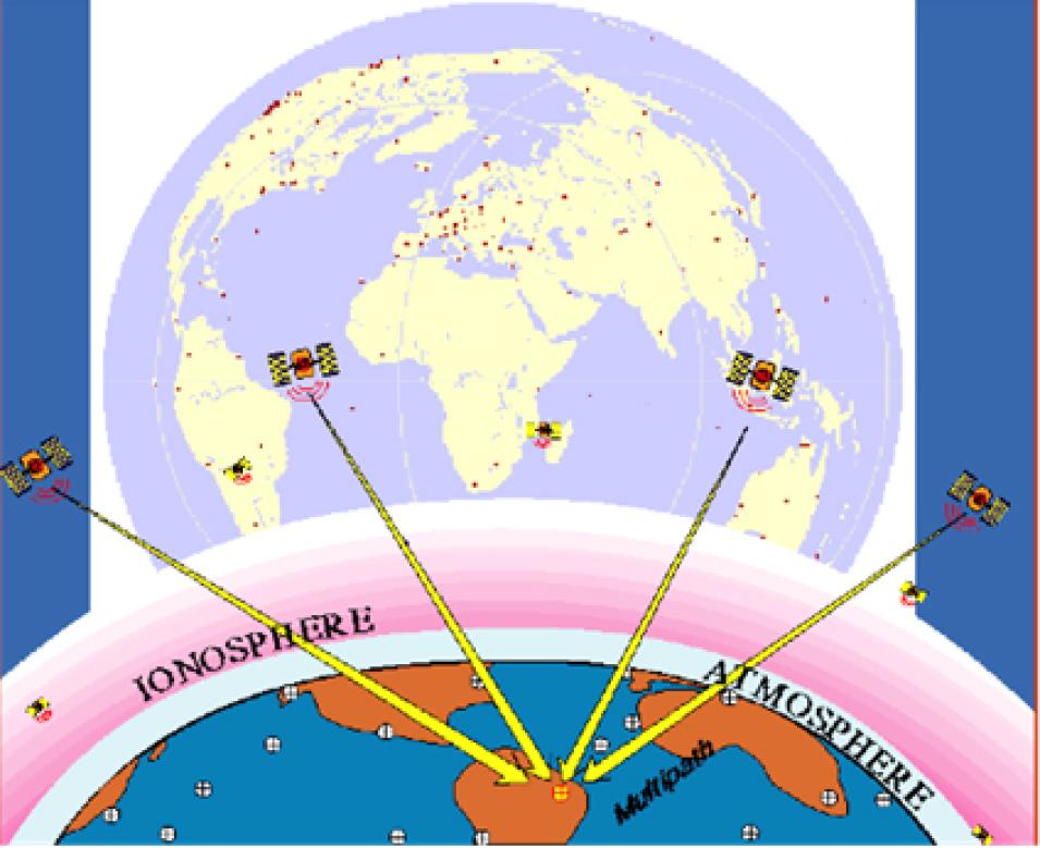
GNSS systems have three components: satellites with synchronized clocks circling the globe in well-known orbits, ground controllers, and a ground segment that provides data to users. Each satellite completes two orbits every day and sends out a unique one-way signal. Ground controllers keep track of satellite orbits and ensure that the clocks aboard each satellite are synchronized. Satellite signals are collected by a global network of receivers that detect, decode, and process these signals. Using signals from at least four satellites, a precise location in three-dimensions (within millimeters or less) along with precise time can be determined for any point on Earth. Further, by comparing measurements over time, minute elevation and distance changes at a station can be calculated. 

GNSS is just one several techniques used in the field of geodesy—the science of measuring and monitoring Earth to determine the exact coordinates of any point on the globe—and it lies at the center of the work of Dr. Sharyl Byram, Chief of the Earth Orientation Parameters Combination and Prediction (EOPCP) and GPS Analysis Division in the Earth Orientation Department of the United States Naval Observatory (UNSO).
Image
Global Navigation Satellite System (GNSS) receivers detect, decode, and process signals from GNSS satellites. These satellites transmit the ranging codes on two radio-frequency carriers, allowing the locations of GNSS receivers to be determined with varying degrees of accuracy, depending on the receiver and post-processing of the data. Credit: NASA Space Geodesy Project.

The UNSO performs the essential scientific tasks of determining the positions and motions of Earth, the Sun, the Moon, other planets, stars, and various celestial objects; determining precise time; measuring Earth's rotation; and maintaining the Master Clock for the United States. The UNSO’s EOPCP branch hosts the International Earth Rotation and Reference Systems Service (IERS) Rapid Service/Prediction Center (RS/PC), which is responsible for providing daily Earth Orientation Parameters (EOPs) to the international community.

"Earth orientation" refers to the direction in space of axes that have been defined on Earth. It is usually measured using five quantities: two angles that identify the direction of Earth's rotation axis within Earth (polar motion), an angle describing the rotational motion of Earth (UT1-UTC), and two angles that characterize the direction of Earth's rotation axis in space (celestial pole). The RS/PC monitors Earth's orientation using these quantities and disseminates the information to a variety of organizations and the public on a continuous basis.

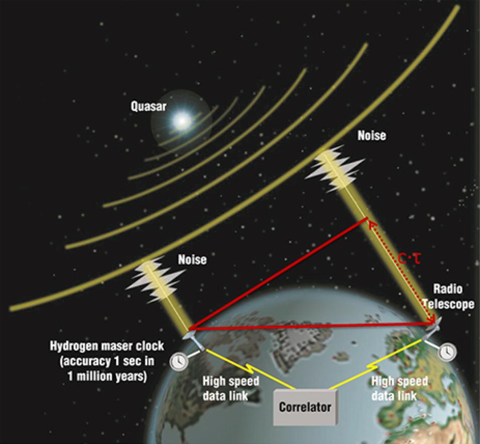
EOPs are the tie between the celestial reference frame (i.e., a stellar object) and the terrestrial reference frame (i.e., an object on Earth, such as a radio antenna) and are derived from a number of different sources. The most precise parameters are determined by a network of radio telescopes that work together using a technique called Very Long Baseline Interferometry (VLBI). USNO maintains a VLBI station at Kōkeʻe Park on the Hawaiian island of Kauai in a partnership with NASA and collaborates with many other radio observatories through the International VLBI Service (IVS) to observe quasars and active galactic nuclei. By observing the same object at the same time with several of these radio telescopes, scientists can measure the precise location of the object on the plane of the sky and also measure the precise location of each telescope on the ground. Data from these diverse telescopes are then sent to USNO via dedicated internet connections or on physical media where they are processed on a dedicated computer system known as the VLBI Correlator.

In addition to the EOPCP, the UNSO’s GPS Analysis branch hosts an International GNSS Service (IGS) Analysis Center (AC) that provides estimations and predictions of the GPS satellite orbits and station clock offsets and Earth orientation parameters that are used in the IGS’s ultra-rapid and rapid combination data products. The AC also provides the IGS Final Troposphere product as well as a UT1-like product known as UTGPS—a GPS-based UT1-like quantity used for extrapolating UT1-UTC beyond the most recent VLBI measurements—used by the EOPCP branch.

These Earth orientation and orbit data are critical for accurate navigation and communications both on Earth and in space, and are vital to the missions of the U.S. Navy and Department of Defense, NASA and other federal agencies, and the public at large (given its use of and reliance on GPS). In fact, without the UT1 measurements, GPS satellites would not be able to provide accurate locations; several NASA Earth Science missions, such as the Ice, Cloud, and land Elevation Satellite 2 (ICESat-2) mission, depend on the UT1 and other EOPs for precise orbit determination.

Image
VLBI is a geometric technique; it measures the time difference between the arrival at two Earth-based antennas of a radio wavefront emitted by a distant quasar. Using large numbers of time difference measurements from many quasars observed with a global network of antennas, VLBI determines the inertial reference frame defined by the quasars and, simultaneously, the precise positions of the antennas. Credit: NASA Space Geodesy Project.

In her role as chief of the EOPCP and GPS Analysis Division, Byram leads a team of scientists who provide consistent and accurate time series of daily EOPs and multiple GNSS estimations per day to the international geodetic community. To accomplish this work, Byram and her team rely on data from several sources, including NASA’s Crustal Dynamics Data Information System (CDDIS), one of 12 Distributed Active Archive Centers (DAACs) in NASA’s Earth Observing System Data and Information System (EOSDIS).

Established in 1992 and located within the Earth Sciences Division at NASA’s Goddard Space Flight Center in Greenbelt, Maryland, CDDIS supports the international geodesy and greater scientific communities by archiving and freely distributing data and derived products from a global network of observing stations equipped with one or more of the following measurement techniques: GNSS, VLBI, Satellite Laser Ranging (SLR)/Lunar Laser Ranging, or Doppler Orbitography and Radio-positioning Integrated by Satellite (DORIS). CDDIS also serves as a global data center in support of the IERS, the International Laser Ranging Service (ILRS), the International VLBI Service for Geodesy and Astrometry (IVS), and the International DORIS Service (IDS), and is one of the core components for the geometric services established under the International Association of Geodesy (IAG), an organization that promotes scientific cooperation and research in geodesy on a global scale.

“To produce its GNSS estimations, the USNO IGS AC uses observations made by globally distributed NASA-operated GNSS receivers (as well as many other agencies which are a part of the IGS network) that are ingested via the CDDIS data server,” Byram said. “For the IERS RS/PC to produce the daily and weekly Earth orientation parameter products, data from NASA VLBI antennas (such as the one in Kōkeʻe Park), as well as the results of data analysis performed at [Goddard], are used to determine Earth’s polar motion and rotation. Most of these data, as well as the resultant USNO data products, are hosted by CDDIS.”

Byram and her colleagues also use CDDIS data in their research to enhance the information they provide.

“There is always a push to improve the models and methods used to produce GNSS estimations and estimate EOPs,” Byram said. “The division is always performing internal research to improve the accuracy of these parameters.”

Image
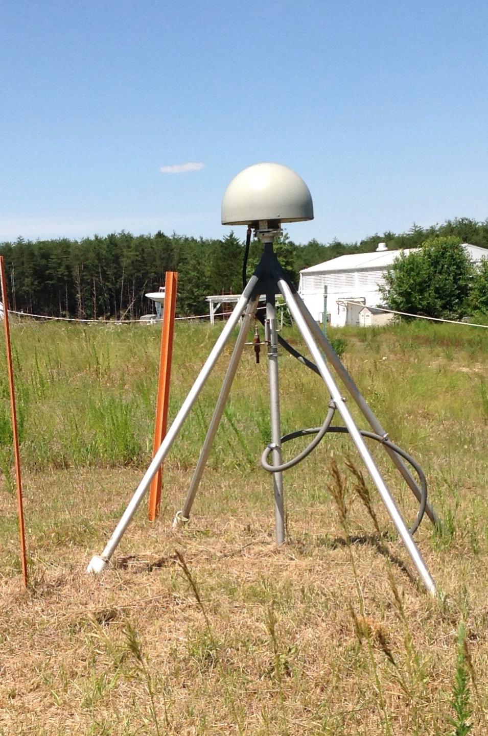
A GNSS antenna at the Goddard Geophysical and Astronomical Observatory (GGAO). The GGAO is one of the few sites in the world to have all four geodetic techniques co-located at a single location: SLR, VLBI, GNSS, and DORIS. Thus, sites like GGAO provide scientists a unique opportunity to assess system performance and perform multi-technique analysis. Credit: NASA Space Geodesy Project.

This research includes the use of new data, investigations of new techniques for determining the motion of Earth, and updating models, methods, and algorithms to better utilize the data currently available.

“We are starting to look at using collocated techniques to improve errors,” Byram said. “For example, VLBI observations rely on atmospheric modelling, which can affect the formal error of the observation. However, many antennas have GNSS receivers nearby, which can provide very low latency troposphere estimates at the time of observation. These estimates can potentially improve the modelled atmospheric delays. We are interested in how using collocated observations could be beneficial.”

There is also the ongoing work of verifying the locations of system resources whose positions have changed in the wake of natural geologic events.

“Our division consulted with a colleague at USNO to help estimate and verify the coordinate displacement of the antenna in Mauna Kea, Hawaii, from the displacement seen in the collocated GNSS receiver after an earthquake event,” Byram said. “By making these types of improvements in the data inputs to our products, it improves the end product that members of the community use as a priori inputs to their research efforts.”

That community includes scientists working in an ever-expanding number of disciplines and fields beyond geodesy. According to NASA’s Space Geodesy Project, geodetic measurements are making fundamental contributions to mitigating the impact of geohazards (e.g., earthquakes, volcanic eruptions, landslides), as the ability to relate measurements to one another in both space and time depends on knowledge of the terrestrial reference frame in which the measurements are made. Geodesy also contributes to meteorological, atmospheric, and hydrological sciences in that its data support the geo-referencing of meteorological data, the global tracking change in stratospheric mass and lower tropospheric water vapor fields, the measurement of water level of major lakes and rivers by satellite altimetry, and improvements in digital terrain models.

Although these disciplines have different aims, they share the need for data that are both accurate and consistent. With the help of the free and open data provided by CDDIS, Byram and her colleagues are able to provide time series of EOPs and GNSS estimations to the international geodetic community several times per day.

Representative Data Products Used or Created:

Available through CDDIS:

Representative Data Products Used or Created:


Explore more Data User Profiles

Last Updated