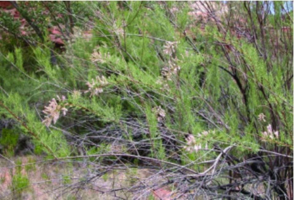
A small tree with needle-like leaves, tiny pink flowers in spring, and a pretty name, tamarisk occupies a million acres in the southwestern United States. Native to Europe and Asia, these small, spreading trees were brought to the United States in the 1800s and prized for their delicate beauty, shade-filtering qualities, and ability to stabilize stream banks. There is no such love anymore for tamarisk in the United States. Now, teams of “tammywackers” spend sweaty, exhausting days trying to eradicate stands of tamarisk, using special jacks to pull these trees up by the roots, or cutting them and painting solutions on the stumps to prevent regrowth. Fighting hundreds of miles of stream bank invasion in Texas, authorities use helicopters to drop herbicides on tamarisk stands along the Pecos River. Despite these measures, the trees continue to spread throughout the southwestern United States, and beyond.
What went wrong? How did this attractive garden specimen become an invasive species, what problems does it cause, and are there better ways to control it? The United States Department of the Interior estimates that invasive plants such as tamarisk cause $20 billion each year in economic damage, and controlling their spread is not cheap either. One group of researchers is developing a new way to outwit invasives like tamarisk. Jeff Morisette, a remote sensing scientist at NASA, said, “We can use remote sensing and models to predict the spread of invasive species. By controlling spread, we can save a lot of time and money.”
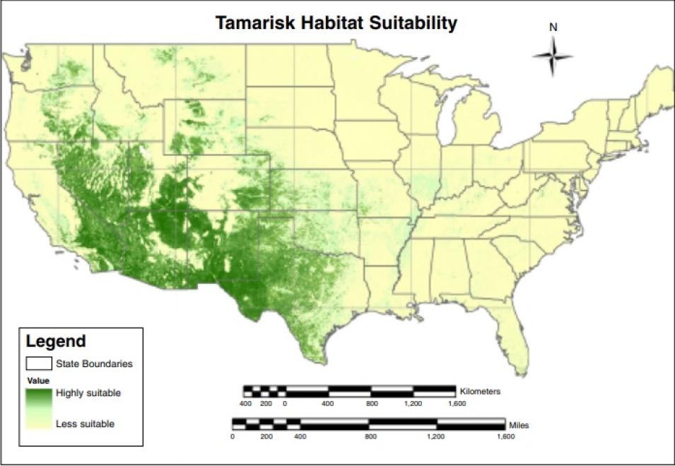
Morisette is part of an interagency team that developed a tamarisk habitat suitability map for the continental United States. Combining several environmental data layers with the analytical powers of a computer model has enabled them to produce a map that indicates where the next stand of tamarisk might crop up.
Knowing the enemy
Tamarisk (Tamarix species) is commonly called salt cedar, so named because it concentrates salts in its leaves. Its leaf litter makes the soil saltier and thus less favorable for other plants. Tenacious and tolerant of poor soils, it spreads aggressively and crowds out native trees, such as cottonwood. “Tamarisk has a deep tap root,” Morisette said. “It can outcompete other plants in drought conditions, which is why it’s a problem in the Southwest.”
Pushing out native species like cottonwood, tamarisk alters bird and insect habitat and so disrupts a long-established local food web. Cottonwood trees have palatable seeds and thick limbs to support large birds like raptors and woodpeckers. But high-density stands of spindly tamarisk offer little structural or microclimatic diversity, and do not harbor the seeds and insects that many birds eat. So the insects and birds that used the cottonwood and other native plants for habitat also decline.
Growing in dense stands, tamarisk changes water flow patterns. Favoring oxbow-shaped bends in watercourses, its stems trap sediments and cause mounding, shallower channels, and increased flooding. Researchers have documented tamarisk spread and river changes along the Brazos River in central Texas over time. From 1941 to 1979, the Brazos became 8 feet shallower and nearly 300 feet narrower. Ranchers and farmers have still more woes. “Tamarisk spreads like grass,” Morisette said. “Thick stands make it hard for livestock to get down to the river for water.”
As stands increase, local groundwater supplies dwindle. Tamarisk is known for its thirst, drawing up large amounts of water and transpiring it into the air through its leaves. This represents a serious impact on human communities in the arid and drought-prone Southwest, where water is a scarce resource for farm irrigation, hydroelectric power, wildlife and livestock, drinking water, and recreation. In southern California, the Metropolitan Water District alone spends millions of dollars each year finding additional water sources to replace the 260 to 570 million cubic meters (340 to 746 million cubic yards) of water lost annually through tamarisk on the Colorado River banks.
Getting ahead of the spread
Tamarisk, once established, is not easy to get rid of. While many non-native species are slow moving and will stay where humans want them, tamarisk escaped cultivation in the 1880s, spreading aggressively through seeds carried on the wind and by wildlife. It also spreads underground, and can reproduce from buried stems or even pieces of stems. Then, land managers must burn, cut, poison, dig, and pull. These methods are expensive and laborious, with negative impacts on the land and native species.
Kara Paintner, a fire ecologist with the United States National Park Service whose expertise is the recovery of native species after wildfires, explained some of the complexities of managing invasive species. Paintner said, “It’s not as simple as just eradicating a species. For example, tamarisk makes the soil more salty, so even after you remove it, the native species have trouble getting re-established. We’ve learned that after you eradicate one invasive species, a worse one may move in. Sometimes it is best to kill everything and replant. So we’ve started to pay more attention to what happens after you eradicate an invasive species.”
Instead of trying to eliminate large, established stands of an invader, resource managers find it more effective to focus on containment. Paintner said, “The Park Service is focusing more on the edge of a species range. The problem isn’t knowing where it is. It’s knowing where it isn’t.” Identifying potential habitat for tamarisk, then watching those areas to prevent tamarisk from becoming established, has become an effective strategy. Yet watching over immense and remote tracts, resource managers cannot continually inspect every riparian area for tamarisk. The maps that Morisette and team are creating can help identify places that tamarisk might grow on a very large scale. While remote sensing has been used to predict invasive plant species before, the novel aspect of this mapping project is its national scale. Tom Stohlgren is a researcher at the United States Geological Survey (USGS) Fort Collins Science Center who works with the National Institute of Invasive Species Science at Fort Collins. He said of the resulting map, “It was like having a weather station every square kilometer, indicating ‘Where is the good life for non-native species?’”
Remote sensing of habitat
“A habitat suitability map works for a species like tamarisk that’s picky about where it lives,” Paintner said. Tamarisk trees need wet soils to survive their first year, like those along a riverbank or where the water table is high, and they need full sun. Tamarisk likes alkaline, fine-textured soils from sea level up to an elevation of about 2,100 meters (6,890 feet). So Morisette and team combined this information with other data to more finely predict where tamarisk would like to grow. The USGS provided geographic layers on soil types and other characteristics, which the researchers then coupled with remote sensing data from the NASA Earth Observing System and climate data. Stohlgren, who works on a project to help collect tamarisk sightings on the ground throughout the United States, supplied additional ground data on tamarisk. The ground observation data identify areas where tamarisk is known to be present, as well as areas where no tamarisk is currently growing.
The remote sensing data, from the Moderate Resolution Imaging Spectroradiometer (MODIS) sensor on NASA’s Terra and Aqua satellites and distributed from NASA's Land Processes Distributed Active Archive Center (LP DAAC), provided two key indicators. MODIS can identify land-cover type, or the kind of vegetation on the ground, by measuring its reflectivity. MODIS measures both the amount of energy and its wavelength across a sensitive spectrum. Different vegetation types - needles, leaves, blades of grass - have different signatures in the data. Tamarisk grows thickly enough to cover soil, and therefore changes the energy reflected from the ground. MODIS can also detect energy changes resulting from a plant’s unique life cycle: dormancy, leaf out, and bloom. “MODIS phenology, or seasonal variation, is helpful for understanding a particular habitat,” Morisette said. “We are using the unique temporal signature of tamarisk habitat to understand where it grows and where it might spread.” A computer model assimilated the many data about tamarisk and its habitat, sorted out all the factors, and marked areas as “highly suitable” and “less suitable” for tamarisk. And that can tell resource managers where tamarisk could be gaining a foothold.
Morisette thinks that the interagency and national approach to habitat mapping can contribute to thwarting tamarisk’s spread. “Because of the spatial extent of the problem, NASA has a lot to contribute - NASA monitors the globe,” he said. “Our view extends beyond park boundaries. We can provide insights to agricultural concerns and other agencies facing this problem.” Paintner agreed, adding, “A lot depends on the park and the species. The Bureau of Land Management and Forest Service have big land blocks and experienced staff. The Park Service has a total of ten million acres to watch, made up of many different parks, with staff of varying knowledge. Someone at a small park with five to ten acres and without much knowledge can miss the new thing to watch for.” This method may also help alert land managers who are not even thinking about tamarisk; surprisingly, the map showed potential habitat in the Midwest. Morisette said, “We found potential for tamarisk invasion in Ohio.” Tamarisk is usually thought of as a scourge of Western states, so the map may help other regions with early detection.
Morisette said, “I’m impressed with the ability of the Parks staff to synthesize so much information about local factors concerning invasive species, anything from seeds in horse feed that wranglers bring in, to air quality concerns that prevent the use of fire to eliminate species. These maps will just add to what is already a dynamic and multifaceted approach to the problem. We are working to figure out how land managers can use this information and integrate it with their decision-making process.” Stohlgren has long called for identifying potential habitat as a means of mitigating spread. “Tamarisk is just the poster child of western invaders,” he said. “We want to move on to many other species.”
References
Hart, Jason. Invasive species in the Southwest: Tamarix sp. (Salt Cedar).
United States Department of Interior. News: National Council promotes strategies for war on invasive plants, animals, pathogens. May 13, 2005.doi:sites/doi.gov/files/archive/news/archive/05_News_Releases/050513b.htm
Zavaleta, Erica. 2000. The economic value of controlling an invasive shrub. AMBIO: A Journal of the Human Environment 29:8, doi:10.1579/0044-7447-29.8.462.
For more information
NASA Land Processes Distributed Active Archive Center (LP DAAC)
The National Invasive Species Forecasting System
About the remote sensing data | ||
---|---|---|
Satellites | Terra and Aqua | |
Sensor | Moderate Resolution Imaging Spectroradiometer (MODIS) | |
Data sets | Normalized Difference Vegetation Index (NDVI) Enhanced Vegetation Index (EVI) |
|
Resolution | 250 meters | |
Parameters | Land-cover type Greenness (onset, peak) |
|
DAAC | NASA Land Processes Distributed Active Archive Center (LP DAAC) |