Shake, Rattle, and Sink

Volcanoes find earthquakes quite unsettling.
author-share

Scientists know that an earthquake can stir up volcanic activity far from its epicenter. On February 20, 1835, a major earthquake in Concepción, Chile woke naturalist Charles Darwin from his nap in Valdivia some 269 miles away. “I happened to be on the shore and was lying down in the wood to rest myself,” he wrote. “There was no difficulty in standing upright, but the motion made me almost giddy. It [felt] something like the movement of a vessel in a little cross-ripple.” In the days following the Concepción earthquake, he counted hundreds of small tremblings, as he called them, and witnessed multiple volcanoes erupting. This pattern of a major earthquake followed by frequent volcanic eruptions repeated itself in the area in 1906 and 1960.

So when an 8.8 magnitude earthquake struck north of Concepción in Maule, Chile on February 27, 2010, nearly two hundred years after Darwin visited the area, scientists were poised to monitor the volcanic stirrings with sophisticated satellite imagery. Yet nothing seemed to be happening. Lead scientist Matthew Pritchard from Cornell University said, “So we were scratching our heads and thinking: Why was this earthquake so different?”

Image
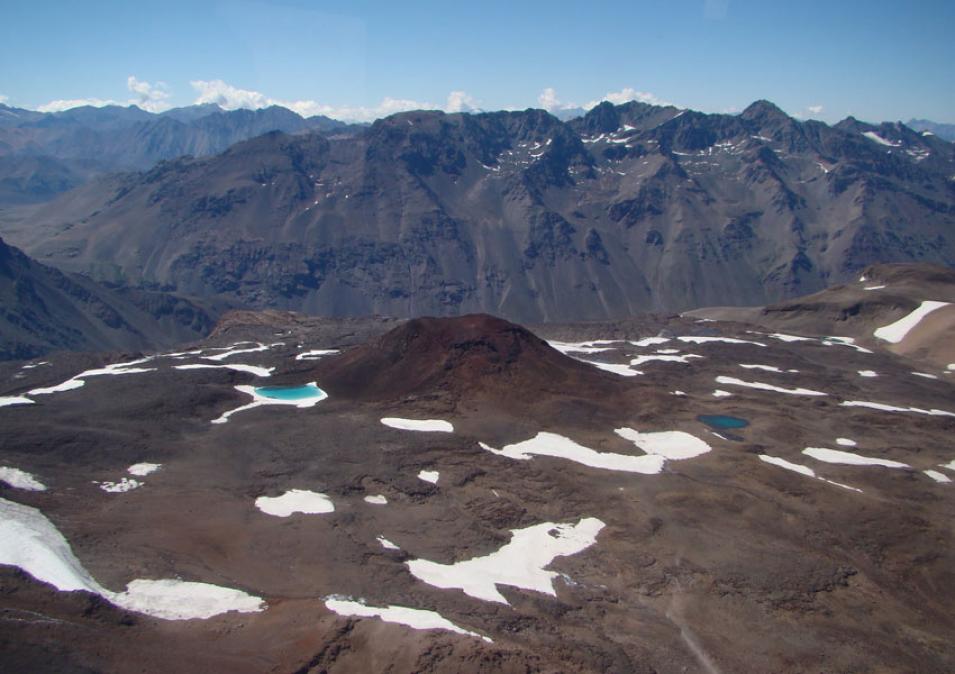
Tinguiririca is one of five volcanoes that subsided during the 8.8 magnitude earthquake in Maule, Chile in 2010. (Courtesy M. Pritchard and L. Lara)

Radar love

Image
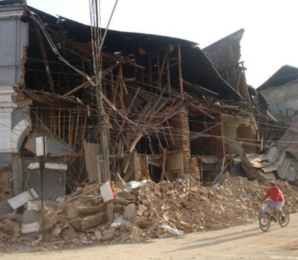
The 2010 Maule quake caused extensive damage to the headquarters of the daily newspaper, La Prensa de Curicó. (Courtesy Decofrut/Flickr)

Pritchard instinctively turned to Interferometric Synthetic Aperture Radar (InSAR). Scientists are fond of this particular remote sensing technique because they are able to comb vast swaths of the Earth—entire volcanic chains, for example—quickly and safely, no matter how remote or dangerous the terrain. InSAR can also detect extremely subtle shifts in the Earth’s surface like rising or sinking, down to millimeters. Such fine detail of displacement above ground can reveal movement underground, such as groundwater flowing beneath cities or magma flowing under volcanoes. Researchers can even detect activity at so-called “zombie volcanoes,” volcanoes believed to have been dead for several million years.

InSAR starts with SAR, which can provide a detailed look at the Earth’s surface. SAR instruments are surprisingly large, at least figuratively speaking. Standard radar uses an antenna to volley high-frequency electromagnetic pulses toward the landscape. How quickly the pulses return to the antenna sketches out a picture of the topography. The larger the antenna, the more detailed the picture, but enormous antennas are a drag on spacecraft. Rather than hauling mile-long revolving antennas to space, SAR relies on the forward movement of the satellite along its flight path to effectively mimic an extremely long antenna scan.

Once the data are gathered, interferometry comes into play. Two SAR scenes from different days are overlaid to create a picture of wave interference. The resulting images, called interferograms, are striking maps that show ground displacement through whorled, concentric rings called fringes. To the uninitiated, colored interferograms tend to look more like 1970s psychedelic art than something retrieved by a satellite. But to researchers studying how the Earth’s surface changes, they speak volumes. Pritchard said, “What you end up with is this beautiful picture that you can look at to see whether there is ground deformation or not.”

That sinking feeling

After the Maule, Chile earthquake, Pritchard and his colleagues were expecting to see the land deformed by a flurry of volcanic eruptions. They developed InSAR images of the area using data from the Phased Array type L-band Synthetic Aperture Radar (PALSAR) instrument, on the Japan Aerospace Exploration Agency and Ministry of Economy, Trade and Industry Advanced Land Observing Satellite (ALOS). The ALOS PALSAR data, although copyrighted by JAXA/METI, are made available through NASA's Alaska Satellite Facility Distributed Active Archive Center (ASF DAAC) to NASA scientists due to the strong partnership developed between JAXA and NASA.

Image
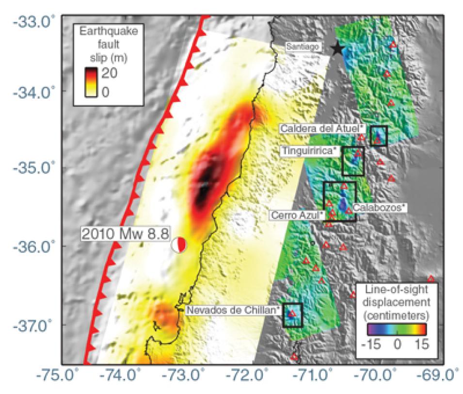
This interferometric map of southern Chile marks where the fault slip occurred after the 8.8 magnitude earthquake near Maule in 2010. The slip is indicated by black and red in the center of the map. The five volcanoes indicated sank several centimeters during the earthquake. Data are from the Phased Array type L-band Synthetic Aperture Radar (PALSAR) instrument on the Japan Aerospace Exploration Agency (JAXA) Advanced Land Observing Satellite (ALOS). (Courtesy M. Pritchard et al., 2013, Nature Geoscience)

They thought they would see the ground surface of the volcanoes in the region lifting up, and shallow underground chambers filling with magma. Cornell team member Jennifer Jay said, “That whole overriding plate should have uplifted.” Instead of uplifting, the volcanoes sank. “What we found was the exact opposite,” Pritchard said. “We found that five volcanoes responded, but they all subsided, so that was a big mystery to us.”

Adding to the mystery, all five volcanoes showed similar changes. All had sunk approximately 5 to 15 centimeters (2 to 6 inches) in elliptical shaped areas that were approximately 10 to 15 kilometers wide by 20 kilometers long (6 to 9 miles by 13 miles). And all five elliptical areas were oriented in a north-south direction. Stymied, the team began running through different scenarios that might explain the odd characteristics.

In the meantime, a 9.0 magnitude earthquake rocked Tohoku-Oki, Japan on March 11, 2011. Though they did not know it at the time, scientists in Japan studying the aftermath found striking similarities to what Pritchard and his team had found in Chile. “It was eerie how similar our results were to theirs,” Pritchard said. Using InSAR data, Youichiro Takada and Yo Fukushima of Kyoto University also found that five volcanoes had subsided. In addition, the size of the sunken areas was comparable. Even their elliptical shape and north to south orientation were similar. “Pritchard’s study is valuable,” Takada said. “With two independent cases, we may say that this is a ubiquitous phenomenon.”

This led to several theories about what might explain the phenomenon. Perhaps the ground shaking allowed volcanic gases to escape, for example. To test this, the Cornell team pored over thermal infrared images from NASA's Advanced Spaceborne Thermal Emission and Reflection Radiometer (ASTER) and Moderate Resolution Imaging Spectroradiometer (MODIS). But the images revealed no change in surface temperature around the five Chilean volcanoes during the sinking. With no sign of hot gases leaking from underground chambers, the Cornell researchers considered other possibilities.

If it holds water

Water, not gas, might be the answer. Streams and rivers flow more vigorously after major earthquakes. Scientists partially attribute this to the ground shaking, which drains ground water reserves through fractures into streams.

Image
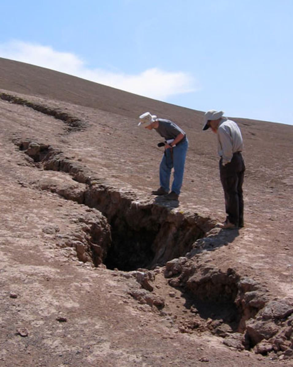
Researchers Matthew Pritchard and Gabriel Gonzalez examine a large crack caused by an earthquake in the Atacama Desert of northern Chile. A major earthquake can cause volcanic unrest hundreds of miles from its epicenter. (Courtesy M. Pritchard and R. Allmendinger)

Stream flow increased again after the 2010 Maule earthquake; Pritchard and his team feel this is key to understanding the ground sinking. “In volcanic areas, there are a lot of hot springs,” he said. “If you visualize Yellowstone, there are pockets of hot fluids coming through and those fluids have minerals in them, which eventually partially clog up the pathways. So our best explanation right now is, when an earthquake shakes them up, the fluids suddenly break through any blockages and are released.” It is possible, then, that this release of fluids somehow made eruptions less likely. And it could explain why the ground around these volcanoes suddenly deflated.

In the case of Japan, magma flow might be key. Takada and Fukushima theorize that the sudden sinking of the five volcanoes near Tohoku-Oki was due to magma flowing out of volcanic chambers. “We think hot and weak plutonic bodies exist in the crust beneath the subsided volcanoes,” Takada said. Unlike the pressure that builds to cause a volcanic eruption, weak rocks called plutons that softened when heated likely allowed the magma to flow out of chambers. What is clear is that both teams independently discovered that volcanoes can sink when shaken.

Jay said, “Because this volcanic subsidence hadn’t been seen before, we did a lot of analysis to make sure this was definitely a real physical phenomenon.” Whether the water and magma theories are proven or disproved remains to be seen, but there is plenty more to learn as InSAR data increasingly become available, particularly with more frequent satellite observations. “Since the [InSAR] technique is relatively new, we don’t have a lot of examples,” Jay said. “And we only get acquisitions every few months, so we really just need more data.”

For both teams there is also still the question of why these underground hydrothermal and magmatic systems have large elliptical shapes. It also remains unclear why they are oriented in a similar north-south direction. One theory is that these features may have something to do with the volcanic arc. Volcano chains that form above a subduction zone and next to a boundary where plates are converging, as both chains had, form a long arc. Identifying future cases of earthquakes triggering volcanic subsidence will help the researchers unravel the mysteries of these processes. Until then, both teams will keep honing their theories. Pritchard said, “Future research will tell us which team is right, or maybe neither of us are. Personally, I think it’s just flat-out cool that there’s stuff happening on the Earth that’s still being discovered.”

References

Darwin, C. 1839. A naturalist’s voyage round the world. Australia: eBooks@Adelaide.

Pritchard, M. E., J. A. Jay, F. Aron, S. T. Henderson and L. E. Lara. 2013. Subsidence at southern Andes volcanoes induced by the 2010 Maule, Chile earthquake. Nature Geoscience 6: 632–636, doi:10.1038/ngeo1855.

Takada, Y. and Y. Fukushima. 2013. Volcanic subsidence triggered by the 2011 Tohoku earthquake in Japan. Nature Geoscience 6: 637–641, doi:10.1038/ngeo1857.

Jónsson, S. Volcanology: Sunken volcanoes. Nature Geoscience 6: 591-592, doi:10.1038/ngeo1876.

NASA Alaska Satellite Facility (ASF) Distributed Active Archive Center (DAAC). 2011. ALOS PALSAR L1 SAR Data. Fairbanks, Alaska USA: NASA ASF DAAC.

NASA Land Processes Distributed Active Archive Center (LP DAAC). 2011. On-Demand L2 Surface Kinetic Temperature. Sioux Falls, South Dakota USA: NASA LP DAAC.

NASA MODIS Level 1 and Atmosphere Archive and Distribution System (LAADS) DAAC. 2011. Terra/Aqua MODIS Calibrated Radiances 5-Min L1B Swath 1 km V005. Version 5. Greenbelt, Maryland: LAADS DAAC.

For more information

NASA Alaska Satellite Facility Distributed Active Archive Center (ASF DAAC)

NASA Land Processes DAAC (LP DAAC)

NASA Level 1 and Atmosphere Archive and Distribution System DAAC (LAADS DAAC)

Japan Aerospace Exploration Agency (JAXA) Advanced Land Observing Satellite (ALOS)

JAXA Phased Array type L-band Synthetic Aperture Radar (PALSAR)

NASA Advanced Spaceborne Thermal Emission and Reflection Radiometer (ASTER)

NASA Moderate Resolution Imaging Spectroradiometer (MODIS)

About the remote sensing data
Satellite Japan Aerospace Exploration Agency Advanced Land Observing Satellite (ALOS)
Sensor Phased Array type L-band Synthetic Aperture Radar (PALSAR)
Data set L1 SAR Data
Resolution 20 meters
Parameter Radar backscatter
DAAC NASA Alaska Satellite Facility Distributed Active Archive Center (ASF DAAC)
About the remote sensing data
Satellites Terra Terra and Aqua
Sensors Advanced Spaceborne Thermal Emission and Reflection Radiometer (ASTER) Moderate Resolution Imaging Spectroradiometer (MODIS)
Data sets On-Demand L2 Surface Kinetic Temperature Nighttime Calibrated Radiances 5-min L1B Seath 1 km V005
Resolution 90 meters 1 kilometer
Parameters Surface kinetic temperature Surface kinetic temperature
DAACs NASA Land Processes Distributed Active Archive Center (LP DAAC) NASA Level 1 and Atmosphere Archive and Distribution System Distributed Active Archive Center (LAADS DAAC)

The photograph in the title graphic shows Nevados de Chillan, which is one of the five volcanoes that sank during the 8.8 magnitude earthquake that struck Maule, Chile in 2010. (Courtesy M. Pritchard and L. Lara)
Last Updated