Dr. James G. Allen

NASA Earth science data help scientists like Dr. James G. Allen develop processes for better satellite retrievals of ocean parameters.

Dr. James G. Allen, Assistant Research Scientist, Goddard Earth Sciences Technology and Research (GESTAR) II Program

Research Interests: Ocean color, phytoplankton photo-physiology, bio-optical modelling, and particle size distribution.

Research Highlights: At first glance, the idea that uncertainty is a critical part of science and a frequent product of scientific investigation might seem counterintuitive. Science (the systematic study of the structure and behavior of physical and natural phenomena through observation, experimentation, and testing) and knowledge go hand-in-hand, and the word science comes from the Latin word scio, meaning “to know.”

Yet, when scientists make a hypothesis, test it through experimentation, and come to a conclusion based on their findings, that conclusion often reveals uncertainties in their results that spur more questions, more hypotheses, and more experiments. This process might sound problematic, circular, and even tiresome, but in the long-term, this uncertainty is beneficial to scientists as it helps them identify the variables that need to be studied to enhance their initial results.

“Uncertainties are scary for some people, but they are promising for others,” says Dr. James G. Allen, assistant research scientist with the Goddard Earth Sciences Technology and Research (GESTAR) II Program at NASA’s Goddard Space Flight Center in Greenbelt, Maryland. “We like to see how we can use those uncertainties in our research. There’s a lot of fun science in every fuzzy number.”

Clearly, Allen is among those who find uncertainty promising, and while his ocean color research projects have varied greatly in recent years, his interest in probing the uncertainties that bubble-up to the surface of his studies has been a recurring theme.

“’How much information can we get out of all the different things in the ocean that we’re measuring?’ is a question I’ve been tackling from a bunch of different perspectives,” said Allen. “For example, can I just build a model from the ground-up using optical theory? Can I use things like Lorenz–Mie theory [a way of conceptualizing the scattering of electromagnetic radiation by a spherical-shaped particle] and build a phytoplankton model from scratch? And then there’s my work on fluorescence. Fluorescence is such a complicated and multifaceted measurement. It’s so influenced by everything. So, I thought, well, if it’s such a sensitive variable, is that something we can actually use?”

Put in simple terms, Allen uses optical satellite data to investigate ocean color, or the study of how visible light interacts with ocean water at both the surface and within the water column. Over the course of his career, he has studied this interaction through a diverse mix of projects.

As a post-doctoral researcher at the University of Hawaiʻi at Mānoa, Allen split his time between two activities. In the first, he worked with the Simons Collaboration on Ocean Processes and Ecology (SCOPE) Gradients campaign to research the use of chlorophyll fluorescence (the luminescence caused by the absorption of radiation) to characterize the function and activity of phytoplankton. In the second, he worked with the science team of NASA's Plankton, Aerosol, Cloud ocean Ecosystem (PACE) satellite mission to develop an Ocean Bio-Optical Model as part of a larger algorithm that takes advantage of all three PACE instruments to characterize the atmosphere, clouds, and ocean simultaneously.

In his current role with GESTAR II, Allen is working on a project that combines data from two sensors aboard NASA’s Terra satellite—the Multi-angle Imaging SpectroRadiometer (MISR) and the Moderate Resolution Imaging Spectroradiometer (MODIS)—to develop a process for producing more accurate retrievals of atmospheric and ocean parameters.
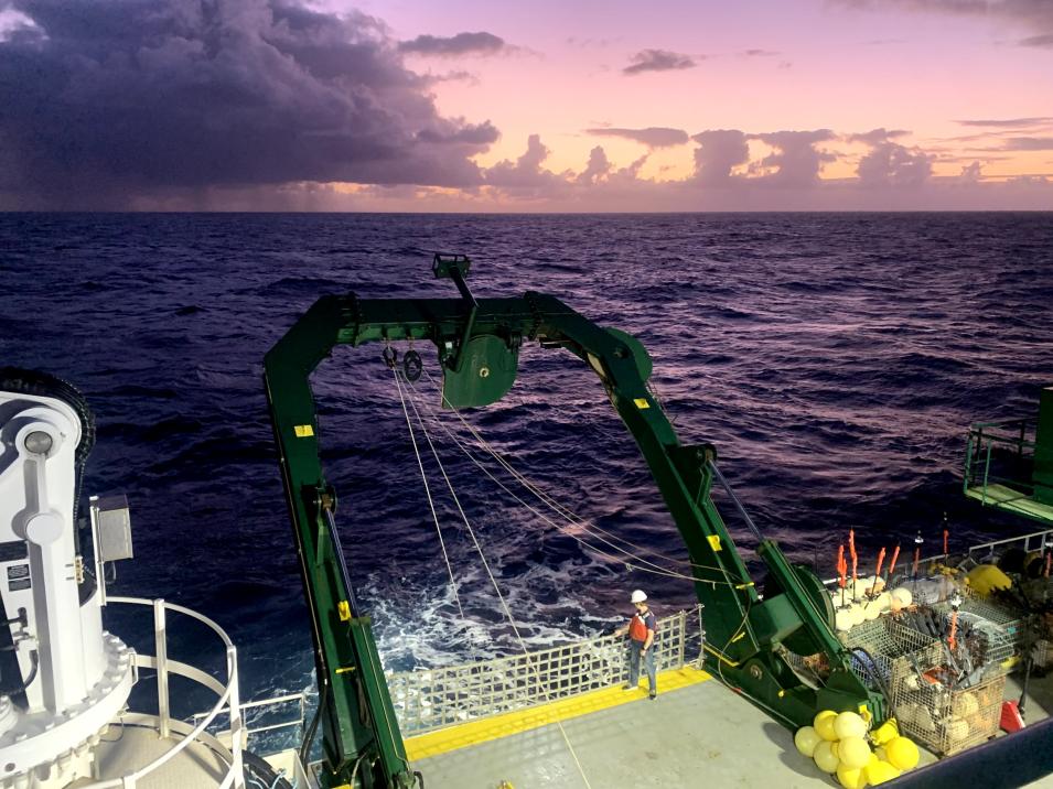
Allen on the stern of the R/V Kilo Moana in August 2021, waiting for the return of an instrument dropped into the sea to collect data.
Image Caption

Allen on the stern of the R/V Kilo Moana north of the Hawaiian Islands in August 2021, waiting on an optical profiler to make measurements at a depth of 200 meters (656 feet). These measurements will provide Allen and his colleagues with a better understanding of how light interacts with different particles and organisms at the ocean surface. Credit: Jennifer Beatty.

Yet, regardless of where he’s working or on what project he’s working, Allen relies on data from several sources, including NASA’s Ocean Biology Distributed Active Archive Center (OB.DAAC), to inform his research. This includes OB.DAAC’s archive of MODIS datasets from the Terra and Aqua satellites and the NASA bio-Optical Marine Algorithm Dataset (NOMAD). NOMAD is a global, high-quality in-situ bio-optical dataset for use in ocean color algorithm development and satellite data product validation, and is available from OB.DAAC's Sea-viewing Wide Field-of-view Sensor (SeaWiFS) Bio-optical Archive and Storage System (SeaBASS) data repository.

“It’s nice to have all of these data provided in such an accessible way,” Allen said. “I can just go to OB.DAAC and there are my satellite remote sensing reflectances and there are all these scripts and tools that make the data easy to download or process.”

Located at NASA’s Goddard Space Flight Center and managed by NASA's Ocean Biology Processing Group (OBPG), OB.DAAC ingests, processes, archives, and distributes data products in NASA’s Earth Observing System Data and Information System (EOSDIS) collection related to ocean biology. OB.DAAC’s ocean color datasets are critical inputs in a wide range of ocean research pertaining to everything from the biology and hydrology of coastal zones and changes in the diversity and geographical distribution of coastal marine habitats, to the influences of biogeochemical fluxes on Earth's ocean and climate and the impact of climate and environmental variability on ocean ecosystems and biodiversity.

While working with the SCOPE campaign, Allen and his colleagues conducted an experiment that used MODIS data along with data from a set of continuous sensors to simultaneously resolve phytoplankton optical properties, size and diversity, and biological production across several ecotones spanning the North Pacific Ocean. Their objective was to characterize changes in the photophysiological characteristics of phytoplankton communities and relate them to corresponding changes in plankton biomass, elemental composition, and community production across a latitudinal gradient in the ocean.

Allen recovers a radiometer during the North Atlantic Aerosols and Marine Ecosystems Study in November 2015.
Image Caption

Allen recovers a radiometer during the North Atlantic Aerosols and Marine Ecosystems Study (NAAMES) cruise in November 2015. The instrument measures downwelling and upwelling light, and its data can be directly related to similar measurements derived from satellite radiometry. Credit: Stuart Halewood.

“One of the things that we were trying to clear up was how much light does it take for phytoplankton to be happy? What does it take for phytoplankton to achieve maximum productivity?” Allen said. “There is a point, though, where you have too much light and the phytoplankton go into light protection mode and re-emit that excess light as heat.”

Given that this boom-and-bust cycle of fluorescence happens on a daily basis with the rising and setting of the Sun, Allen and his colleagues wanted to see if they could pinpoint the phytoplankton’s light saturation level—the point at which fluorescence in phytoplankton begins to decrease as more light is added—as it’s an important parameter for ocean primary productivity models.

“It’s a really important parameter because it can tell you how much light is required for phytoplankton to photosynthesize at maximum efficiency," said Allen. "Once you know that number, you can start estimating how much carbon is made and how much carbon might sink to the bottom of the ocean or get re-mineralized. But all it starts with having that saturation number.”

According to Allen, it’s difficult to get this measurement from satellites because optical instruments that use visible or near-infrared light to capture images of Earth’s surface depend on the Sun as their source of illumination. This could change, however, if the threshold was quantified. As he and his colleagues write in the conclusion of their 2022 paper on this study: “If it can be related quantitatively to the saturation irradiance for photosynthesis, this fluorescence threshold . . . could become a useful optical signal that can be acquired in high resolution from a variety of moored and profiling platforms, providing valuable information on photo-physiological patterns in sea surface phytoplankton assemblages and leading to improved models of marine primary productivity.”

Allen is working on a follow-up study that uses the same optical methodology to investigate the use of fluorescence in approximating iron limitation in the phytoplankton found in the waters between the North Pacific Gyre and the Equatorial Pacific. Low or limited amounts of iron in ocean water has been cited as the reason for the slow growth of phytoplankton in waters with high levels of nutrients, but where phytoplankton aren’t growing as expected (these areas also are called high-nutrient, low-chlorophyll [HNLC] waters). Yet, this is easier said than done due to the variety of factors that affect fluorescence.

Allen retrieves samples from a CTD Rosette, which collects water samples at specified ocean depths.
Image Caption

Allen retrieves samples from a CTD Rosette, which collects water samples at specified ocean depths. These samples will eventually go through a series of filters and instruments to measure their components (i.e., particles, phytoplankton pigments, etc.) and absorption properties. Credit: Stuart Halewood.

“Fluorescence is a very complicated measurement. There are so many things that influence it: pigment and community composition, particle size, light and nutrient stress, and so on,” Allen said. “But because the sensors offer high spatial and temporal resolution, and because you can expose the phytoplankton to many different wavelengths of light, you may be able to start pulling out, ‘Oh, this is what I expect to see for iron limitation’ and, ‘There’s this mechanistic biological or chemical reason why iron limitation causes this exact thing to happen with fluorescence.’ It’s a big question, but it’s fuzzy and we’re still working on it.”

Reducing that fuzziness involves a lot of number crunching, but if the accounting by Allen and his colleagues is accurate, it will improve scientists’ understanding of the way nutrient limitation impacts different ocean regions, especially as more sophisticated sensors like PACE come online.

Allen’s current GESTAR II research also seeks to minimize the uncertainty lurking in ocean measurements through the development of new approaches that use data from multiple satellite instruments to produce better retrievals of atmospheric and ocean parameters.

“My project combines the multi-angle strength of Terra’s MISR, which only has four wavelengths but measures nine different angles, to hone-in on atmospheric information like aerosols and wind speed,” said Allen. “Then I’ll apply Bayesian inferences to MODIS atmospheric corrections that incorporate the MISR numbers to get stronger confidences on our ocean reflectances.”

Bayesian inference is a type of statistical thinking in which the probability or likelihood of a particular outcome changes depending on the available information. Allen is applying this approach to the process of producing satellite reflectances to minimize their uncertainties.

“The traditional style of developing satellite retrievals is to calculate all my different models over and over again to see how close I can get to what the satellite is actually seeing. Then I tweak the parameters a little bit to see how sensitive the model is to those changes, which gives me an idea about its uncertainty,” Allen said. “If I tweak the parameter a little bit and get a massive change, then I’m right there where I need to be. But if I can tweak it a lot and I still get the same answer, I’m probably a bit more uncertain about that retrieval.”

By applying Bayesian inference, Allen can determine the relationship of each parameter to the data from one satellite instrument and then apply what he learns to the data from the other instrument. “This is what I’m trying to do with MISR: get that fuzzy atmospheric information based on the instrument’s nine angles and apply it to MODIS data," he said. "From that you can do additional Bayesian inferences to determine the probabilities of the ocean color parameters while increasing our confidence on the atmospheric retrievals, because MODIS has higher spectral resolution.”

For Allen, the result of this process is what he describes as an “information content system” that researchers can use to produce better retrievals from satellite observations.

“This approach helps us rethink what a retrieval really is in this kind of space. As I add information, Bayesian inference shows what happens to my confidence in regard to all the possibilities out there,” Allen said. “We’re starting with, 'the atmosphere could be anything.' Then I add MISR data at nine angles and, ‘Oh, now I feel a lot more confident that I’m over in this parameter space for the atmosphere. Now that I have that first bit of knowledge to apply to the ocean color sensor, what happens to the ocean color parameters with those extra bits of information?’”

Ultimately, Allen hopes to develop a Bayesian workflow to take advantage of what he foresees as the flood of data the ocean color community will soon get from PACE.

“We’re entering a new world of huge amounts of Earth observation data coming from many different sources, and I’m incredibly excited for all the new paradigms we’ll be developing to help us understand it all,” Allen said.

When that happens, OB.DAAC will be there to ingest, processes, archive, and distribute these data to the scientists within the ocean color community so they can make the best use of it in their ongoing efforts to better understand the ocean’s biological processes and their effect on the greater Earth system.

Representative Data Products Used or Created

Available through NASA's OB.DAAC:

Other Data Products Used

Read About the Research

Stamnes S., Jones M., Allen J.G., Chemyakin E., Bell A., Chowdhary J., Liu X., Burton S.P., Van Diedenhoven B., Hasekamp O., Hair J., Hu Y., Hostetler C., Ferrare R., Stamnes K., & Cairns B. (2023). The PACE-MAPP algorithm: Simultaneous aerosol and ocean polarimeter products using coupled atmosphere-ocean vector radiative transfer. Frontiers in Remote Sensing, 4:1174672. doi: 10.3389/frsen.2023.1174672

Allen, J.G., Dugenne, M., Letelier, R.M., & White, A.E. (2022). Optical determinations of photophysiology along an ecological gradient in the North Pacific Ocean. Limnology and Oceanography, 67(3): 713-725. doi:10.1002/lno.12031

Allen, J.G., Siegel, D.A., Nelson, N.B., & Halewood, S. (2020). Controls on Ocean Color Spectra Observed During the North Atlantic Aerosols and Marine Ecosystems Study (NAAMES). Frontiers in Marine Science, 7. doi.10.3389/fmars.2020.567007

Explore more Data User Profiles

Details

Last Updated

Data Center/Project

Ocean Biology DAAC (OB.DAAC)