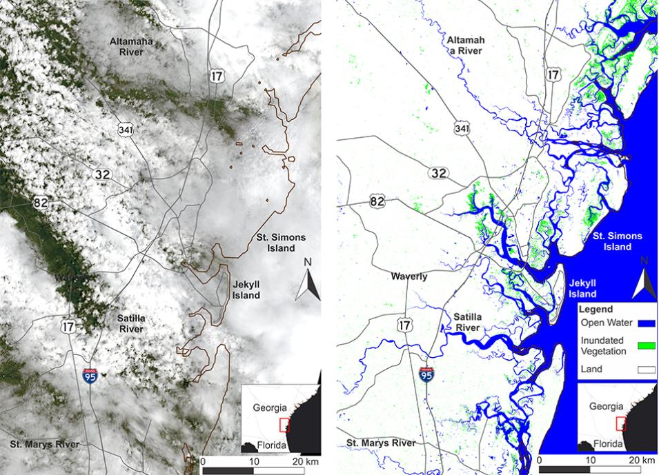
A new NASA dataset gives researchers, decision-makers, and disaster responders the ability to get satellite views of surface water extent day or night regardless of the weather and practically anywhere on Earth. The Level 3 Dynamic Surface Water Extent product (DSWx-S1) is derived from synthetic aperture radar (SAR) data acquired by the ESA (European Space Agency) Sentinel-1 platform.
DSWx-S1 is produced by the Observational Products for End-Users from Remote Sensing Analysis (OPERA) project. OPERA is managed by NASA’s Jet Propulsion Laboratory (JPL) in Southern California and partners with NASA’s Goddard Space Flight Center in Greenbelt, MD, the USGS, the University of Maryland College Park, the University of Alaska Fairbanks, and Southern Methodist University. The project is funded through the U.S. Group on Earth Observations (USGEO) Satellite Needs Working Group (SNWG). SNWG works with federal agencies to determine their Earth observation needs. The water extent product is the latest of multiple remote sensing solutions OPERA is developing to provide key data to U.S. Federal agencies.
Surface Water Everywhere
“DSWx-S1 is a product with many applications spanning hazard response, resource management, and environmental monitoring,” said OPERA project manager Dr. David Bekaert. Examples of how DSWx-S1 could be used include disaster assessment during or after storms, water management such as monitoring reservoirs, and the study of wetland ecology. The data are also useful for calculating river or lake size, flooding severity, sea level rise and subsequent coastal changes, seasonal fluxes, or other measurements of where water is going.
DSWx-S1 maps are generated with weekly SAR data sampling from Sentinel-1 and include all global landmasses excluding Antarctica. OPERA also produces related optical surface water extent products based on Harmonized Landsat 8 and Sentinel-2 A/B (HLS) data, which offer the benefit of nearly daily imagery but with the limitation that these optical instruments cannot acquire data through overcast skies or during nighttime as SAR instruments can.
“This new radar surface water extent dataset is an excellent complement to the optical products we already have in production—especially in the presence of clouds,” said Bekaert. “In addition to the 24/7, all-weather views of surface water, the radar capability allows OPERA to also include an inundated vegetation data layer for wetland areas.”
Maps for Hurricane Response
While global in scope, DSWx-S1 has already been put to important use in the United States in response to hurricanes Helene and Milton in the fall of 2024. When the hurricanes struck, the NASA Disaster Response Coordination System (DRCS) included the product in the NASA Disasters Mapping Portal. The DRCS is a whole-of-NASA approach that leverages Earth science, technology, and expertise to provide trusted and actionable information to organizations actively responding to disasters. DRCS made DSWx-S1 available to the Federal Emergency Management Agency (FEMA) and other agencies to identify and map areas flooded by the hurricanes.
DSWx-S1 Details
The input dataset for generating each DSWx-S1 product is the OPERA Level-2 Radiometric Terrain Corrected SAR Backscatter Product from Sentinel-1 A/B (RTC-S1). The DSWx-S1 algorithm differentiates the RTC-S1 data into three classes: water, no-water, and inundated vegetation. The product is arranged into Military Grid Reference System (MGRS) tiles, with each tile covering an area of 109.8 km × 109.8 km.
The DSWx-S1 product is distributed as a set of four GeoTIFF files corresponding to each DSWx-S1 data layer and one browsing image. The GeoTIFF files are saved as Cloud-Optimized GeoTIFFs (COGs) to make retrieval of the data from cloud-based storage more efficient. DSWx-S1 datasets can be retrieved from NASA Earthdata Search as well as from NASA’s Physical Oceanography Distributed Active Archive Center (PO.DAAC).
For more details on DSWx-S1, visit OPERA’s DSWx Product Suite homepage to find technical documentation, interactive guides, and tutorials.
