NASA’s constellation of Earth observing satellites constantly collect data about Earth and acquire some pretty amazing images of our planet. NASA's Worldview imagery mapping and visualization application lets you interactively explore this tremendous trove of NASA Earth science data and imagery—and even create snapshots and animated GIFs to share with friends. This Earth Day imagery gallery provides tips for exploring the Worldview gallery images, resources to show you how NASA studies Earth, and links to activities to help you learn more about how our amazing planet works.
Creating your own NASA Worldview Earth Day image is easy. Start with this tutorial:
Engage in more Earth Day at Home activities: www.nasa.gov/earthday
Imagery Gallery
Image | Earthdata Resources |
---|---|
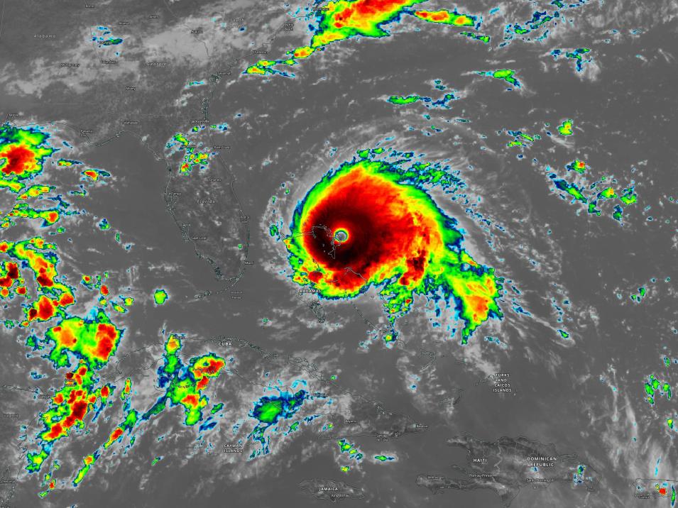
Hurricane Dorian
Hurricane Dorian made landfall on the Bahamas at 16:40 UTC (12:40PM ET), on September 1, 2019 as a Category 5 hurricane (indicating winds greater than 155 mph). This Geostationary Operational Environmental Satellite-East (GOES-East) Clean Infrared (10.3μm, Band 13) image acquired on September 1, 2019, at 17:00 UTC (1:00PM ET) shows that the cloud-top brightness temperatures near the center of the hurricane are below -70°C (-94°F). Viewing Tips: Hover over the different colors in the image to see the corresponding temperature value in the Layer List in NASA Worldview. This layer is useful for detecting clouds during the day and at night and aiding in cloud and other atmospheric feature identification and classification. Explore Image in NASA Worldview: https://go.nasa.gov/38pwn2g |
NASA Worldview Tour of Hurricane Dorian: https://go.nasa.gov/3ctUSht To view more hurricane imagery, visit the Worldview Image of the Week Archive and type “Hurricane” into the search box: https://go.nasa.gov/2VlPIww Explore Near Real-Time Data Related to Severe Storms: https://go.nasa.gov/2JZ0aFi |
Raikoke Volcano Eruption, Kuril Islands, Russia
This true-color corrected reflectance image of the ash plume from the Raikoke Volcano eruption was acquired on June 22, 2019 by the Moderate Resolution Imaging Spectroradiometer (MODIS) instrument, aboard NASA's Terra satellite. This volcano is located within the Kuril Islands on the Kamchatka Peninsula in Russia. Viewing Tips: The brown plume in the center of the image is the ash plume from the eruption. To see how this ejected aerosols into the atmosphere, go to NASA Worldview and turn on the Aerosol Index Suomi National Polar orbiting Partnership / Ozone Mapping Profiler Suite (Suomi NPP / OMPS) layer to see the high levels of aerosols shown in red. The Aerosol Index is a unitless range from <0.00 to >=5.00, where 5.0 indicates heavy concentrations of aerosols that could reduce visibility or impact human health. Explore Image in NASA Worldview: https://go.nasa.gov/3c5GVFY |
To explore more volcano imagery, visit NASA's Worldview Image of the Week Archive and type “Volcano” into the search box: https://go.nasa.gov/2VlPIww Explore Near Real-Time Data related to Ash Plumes: https://go.nasa.gov/2JxvB9y Data User Profile: Dr. Mike Ramsey develops new ways to study active volcanoes and to provide data to support emergency response. https://go.nasa.gov/2UAkjb1
|
Iceberg B49 Calves from Pine Island Glacier, Antarctica
True-color corrected reflectance image of iceberg B49, which calved from the Pine Island Glacier, acquired on February 15, 2020 by the Moderate Resolution Imaging Spectroradiometer (MODIS) instrument, aboard NASA’s Aqua satellite. Viewing Tips: View an animation in NASA Worldview (https://go.nasa.gov/2VhvsMO) of the iceberg moving away from the Pine Island Glacier between February 8 and 15, 2020. Explore Image in NASA Worldview: https://go.nasa.gov/2xiEVf3 |
To explore iceberg imagery in Worldview, visit the NASA Worldview Image of the Week Archive and type “Iceberg” into the search box: https://go.nasa.gov/2VlPIww Explore Near Real-Time Data Related to Sea Ice: https://go.nasa.gov/2ys36rB Learn how NASA’s ICESat-2 mission is measuring Earth’s frozen regions in unprecedented detail: https://go.nasa.gov/2JyqS7z Data User Profile: Dr. Ludovic Brucker investigates climate-related changes in Earth’s frozen regions. https://go.nasa.gov/2K52Ilf |
Fires in New South Wales, Australia
Beginning in September 2019, Australia experienced one of their worst fire seasons on record. This joint NASA/NOAA Suomi NPP Visible Infrared Imaging Radiometer Suite (VIIRS) image acquired on January 4, 2020, shows extensive smoke plumes from bushfires burning in New South Wales, Australia. Viewing Tips: View active fires/hotspots by turning on the Active Fires/Thermal Anomalies imagery layers in NASA Worldview. Just click on the “eye” icon. Explore Image in NASA Worldview: https://go.nasa.gov/3c5rr4V |
NASA Worldview Tour of Australian Fires: https://go.nasa.gov/3ebij0n NASA Worldview Tour on Satellite Detections of Fire: https://go.nasa.gov/2JOv2bD Feature Article - Wildfires Can't Hide from Earth Observing Satellites: This article describes how satellite data and NASA's Fire Information for Resource Management System (FIRMS) can be used to help manage ongoing fires and track the spread of fires around the world. https://go.nasa.gov/3cdGr0w Wildfires Data Pathfinder: Provides links to datasets, services and tools that can be used to aid in wildfire management and post-event evaluation. https://go.nasa.gov/3dOIj1k Data User Profile: Dr. Nancy French studies the effects of wildfires on forest ecosystems. https://go.nasa.gov/2UMorTS |
Nighttime Lights - United States
Viewing Earth at night affords us a different view of Earth's surface. We may be used to seeing the true-color satellite images that mimic what the human eye perceives, but the night lights layer shows Earth at night and the illuminations that emanate from Earth back into space. Viewing Tips: What are the three or four major cities that can be viewed in this image? Explore this image in NASA Worldview and turn on the Place Labels layer to see what cities are along this major highway corridor. Explore Image in Worldview: https://go.nasa.gov/34Ihrw8 |
NASA Worldview Tour of Earth At Night: https://go.nasa.gov/2JTRgsw Feature Article - Bringing Light to the Night: New VIIRS Nighttime Imagery Available through GIBS. https://go.nasa.gov/3bdPsqs Data User Profile: Dr. Adam Storeygard uses nighttime lights data for economic studies of urbanization and development. https://go.nasa.gov/3aD1FVl Data User Profile: Dr. Karen Seto uses nighttime lights data to study the environmental effects of urbanization. https://go.nasa.gov/3dIunpX |
Dust Storm over Canary Islands
This true-color image from the Visible Infrared Imaging Radiometer Suite (VIIRS), aboard the joint NASA/NOAA Suomi NPP satellite shows a dust storm blowing over the Canary Islands on February 22, 2020. Viewing Tips: Press “Play” in NASA Worldview to view an animation (https://go.nasa.gov/34q1vOE) of the dust storm moving over the Canary Islands and out to the ocean. Explore Image in Worldview: https://go.nasa.gov/39tyUtF |
NASA Worldview Tour on Dust Storms: https://go.nasa.gov/2VafcgE Explore Near Real-time Data Related to Dust Storms: https://go.nasa.gov/39yLhDZ Data User Profile: Dr. Santiago Gassó studies the concentration and global movement of dust. https://go.nasa.gov/2R4L453 Data User Profile: Dr. Greg Jenkins studies how dust impacts weather, climate, atmospheric chemistry, and air quality of West Africa. https://go.nasa.gov/2R3Ds2D |
Other NASA Resources
NASA Earth Observatory - Explore images, stories, and discoveries about the environment, Earth systems, and climate that emerge from NASA research, including its satellite missions, in-the-field research, and models.
NASA Scientific Visualization Studio - Discover Earth and Space Science visualizations, animations, and images in order to promote a greater understanding of research activities at NASA.
My NASA Data - Resources organized around the Earth System Science phenomena that you teach.