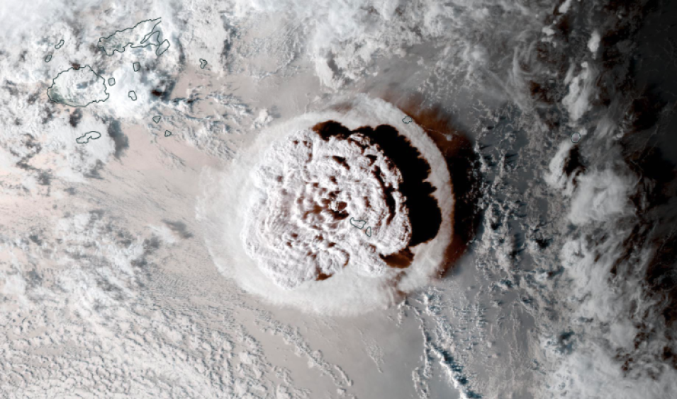
GeoColor reflectance image animation of the explosive eruption of the Hunga Tonga-Hunga Ha'apai volcano on January 15, 2022, between 04:00 - 05:20 UTC/17:00 - 18:20 Tonga Time. These images were acquired by the Advanced Baseline Imager (ABI) instrument, aboard the GOES-West (currently, GOES-17) satellite. Click on the image to visit Worldview, when there, click on the play button in the lower left corner, above the date, to start the animation. The eruption caused a tsunami that spread across the Pacific Ocean.
The GeoColor (True-Color (Day), Multispectral-blended infrared (IR; at Night)) layer from the GOES-East Advanced Baseline Imager (ABI) provides an approximation to daytime True Color imagery. The combination of spectral bands yields an appearance similar to what the human eye would perceive for land surface, oceanic and atmospheric features, with atmospheric correction used to make the appearance of these features sharper. Thus it is used primarily for the intuitive interpretation of meteorological and surface-based features such as smoke, blowing dust, and vegetation types (forests, deserts, croplands, etc.).
At night, the true color imagery gives way to IR-based blended multispectral imagery that provides differentiation between low liquid water clouds (shown in light blue) and higher ice clouds (shown in gray/white). It also includes a static city lights/night lights database derived from the VIIRS Day/Night Band, which aids in geo-referencing and can help determine the proximity of clouds (such as fog) or weather hazards (such as thunderstorms or tropical cyclones) to population centers. Please note that as these lights are static, they will not change even if, for example, a weather-induced power outage occurs.
GeoColor Imagery provided by NOAA/NESDIS/STAR.
Visit Worldview to visualize near real-time imagery from NASA's EOSDIS, and check out more Worldview weekly images in our archive.
