N: 54 S: -54 E: 180 W: -180
Description
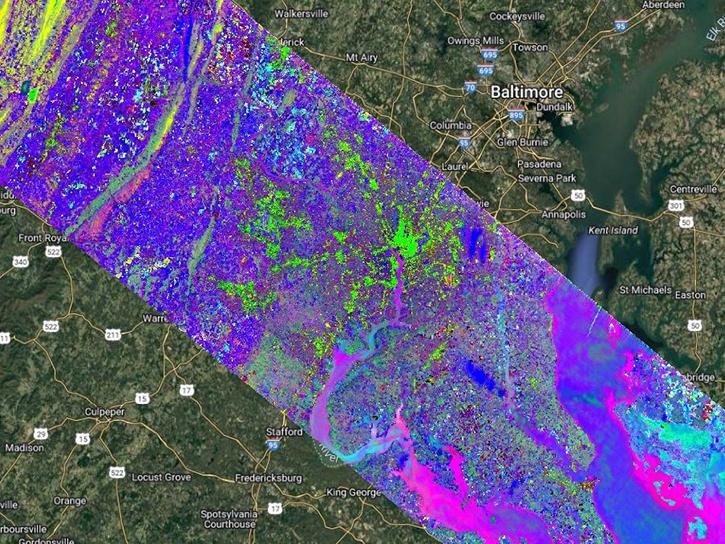
The Earth Surface Mineral Dust Source Investigation (EMIT) instrument measures surface mineralogy, targeting the Earth’s arid dust source regions. EMIT is installed on the International Space Station (ISS) and uses imaging spectroscopy to take mineralogical measurements of sunlit regions of interest between 52° N latitude and 52° S latitude. An interactive map showing the regions being investigated, current and forecasted data coverage, and additional data resources can be found on the VSWIR Imaging Spectroscopy Interface for Open Science (VISIONS) EMIT Open Data Portal.
The EMIT Level 1B At-Sensor Calibrated Radiance and Geolocation (EMITL1BRAD) Version 1 data product provides at-sensor calibrated radiance values along with observation data in a spatially raw, non-orthocorrected format. Each EMITL1BRAD granule consists of two Network Common Data Format 4 (NetCDF4) files at a spatial resolution of 60 meters (m): Radiance (EMIT_L1B_RAD) and Observation (EMIT_L1B_OBS). The Radiance file contains the at-sensor radiance measurements of 285 bands with a spectral range of 381-2493 nanometers (nm) and with a spectral resolution of ~7.5 nm, which are held within a single science dataset layer (SDS). The Observation file contains viewing and solar geometries, timing, topographic, and other information related to the observation.
Each NetCDF4 file holds a location group containing geometric lookup tables (GLT), which are orthorectified images that provide relative x and y reference locations from the raw scene to allow for projection of the data. Along with the GLT layers, the files also contain latitude, longitude, and elevation layers. The latitude and longitude coordinates are presented using the World Geodetic System (WGS84) ellipsoid. The elevation data was obtained from Shuttle Radar Topography Mission v3 (SRTM v3) data and resampled to EMIT’s spatial resolution.
Each granule is approximately 75 kilometers (km) by 75 km, nominal at the equator, with some granules at the end of an orbit segment reaching 150 km in length.
Known Issues
- Data acquisition gap: From September 13, 2022, through January 6, 2023, a power issue outside of EMIT caused a pause in operations. Due to this shutdown, no data were acquired during that timeframe.
Product Summary
Citation
Citation is critically important for dataset documentation and discovery. This dataset is openly shared, without restriction, in accordance with the EOSDIS Data Use and Citation Guidance.
Copy Citation
File Naming Convention
The file name begins with the Sensor (EMIT) followed by the Processing Level (L1B), Product Type (RAD), Product Version Number (001), Date and Time of Acquisition designated as YYYYMMDDTHHMMSS (20250911T043136), Orbit Identification Number (2525403), Scene Identification Number (019), and the Data Format (nc).
Documents
USER'S GUIDE
ALGORITHM THEORETICAL BASIS DOCUMENT (ATBD)
SCIENCE DATA PRODUCT SOFTWARE DOCUMENTATION
PUBLICATIONS
Dataset Resources
Variables
The table below lists the variables contained within a single granule for this dataset. Variables often contain observed or derived geophysical measurements collected from a variety of sources, including remote sensing instruments on satellite and airborne platforms, field campaigns, in situ measurements, and model outputs. The terms variable, parameter, scientific data set, layer, and band have been used across NASA’s Earth science disciplines; however, variable is the designated nomenclature in NASA’s Common Metadata Repository (CMR). Variable metadata attributes such as Name, Description, Units, Data Type, Fill Value, Valid Range, and Scale Factor allow users to efficiently process and analyze the data. The full range of attributes may not be applicable to all variables. Additional information on variable attributes is typically available in the data, user guide, and/or other product documentation.
For questions on a specific variable, please use the Earthdata Forum.
| Name Sort descending | Description | Units | Data Type | Fill Value | Valid Range | Scale Factor |
|---|---|---|---|---|---|---|
| elev | Elevation | Meters | float64 | -9999 | N/A | N/A |
| fwhm | Full width at half maximum | Nanometers | float32 | -9999 | N/A | N/A |
| glt_x | Geometric lookup table – x values | N/A | int32 | -9999 | 1 to 1242 | N/A |
| glt_y | Geometric lookup table – y values | N/A | int32 | -9999 | 1 to 2559 | N/A |
| lat | Latitude | Degree | float64 | -9999 | -90 to 90 | N/A |
| lon | Longitude | Degree | float64 | -9999 | -180 to 180 | N/A |
| obs | 3D array with band parameters specified | N/A | float32 | -9999 | N/A | N/A |
| observation_bands | Array of strings indicating the name of each observation band | N/A | OTHER | N/A | N/A | N/A |
| radiance | Radiance Data | μW/cm²/sr/nm | float32 | -9999 | N/A | N/A |
| wavelengths | Wavelength centers | Nanometers | float32 | -9999 | N/A | N/A |

