We are in the process of migrating all NASA Earth science data sites into Earthdata from now until end of 2026. Not all NASA Earth science data and resources will appear here until then. Thank you for your patience as we make this transition.
Read about the Web Unification Project
OSTM/Jason-2 Resources
OSTM/Jason-2 Documents
| Name Sort descending | Description | File Type | Date Published | |
|---|---|---|---|---|
| Maneuver List for OSTM/Jason-2 | Satellite attitude event information for Ocean Surface Topography Mission/Jason-2. | RTF (64.23 kb) | ||
| OSTM Safe Holds | A list of safe holds for the Ocean Surface Topography Mission (OSTM). | RTF (1.35 kb) | ||
| OSTM/Jason-2 Cycle List | Start times of Ocean Surface Topography Mission (OSTM) cycles. | RTF (11.11 kb) | ||
| OSTM/Jason-2 Handbook | Handbook for Ocean Surface Topography Mission(OSTM)/Jason 2 data users. | PDF (1.13 mb) | Aug. 3, 2009 |
OSTM/Jason-2 Learning Resources

TOPEX/Poseidon provided more than 13 years of data, while two follow-on missions—Jason-1 and Jason-2—have extended the time series of data to more than 20 years.
Data in Action
Dec. 12, 2012
SHOWING 1 OF 17
OSTM/Jason-2 News
View All News
Filters

Sentinel-6B observations will also inform early warnings and forecasts systems.
News
Dec. 16, 2025

The global average sea level is rising. Dr. Philip Thompson uses NASA Earth science data to explore how—and when—this will affect vulnerable communities.
Data User Story
Dec. 22, 2020
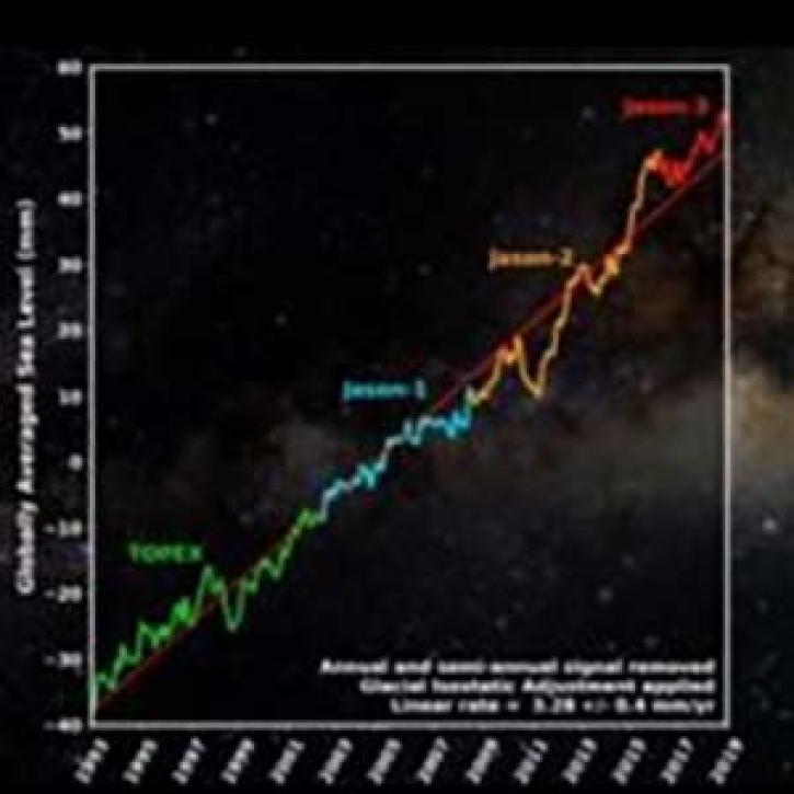
Using data from four ocean altimetry missions, a new PO.DAAC animation shows more than a quarter-century of global average sea level change.
News
Nov. 4, 2020
SHOWING 3 OF 3
Frequently Asked Questions
Earthdata Forum
Our online forum provides a space for users to browse thousands of FAQs about research needs, data, and data applications. You can also submit new questions for our experts to answer.
Submit Questions to Earthdata Forumand View Expert Responses