We are in the process of migrating all NASA Earth science data sites into Earthdata from now until end of 2026. Not all NASA Earth science data and resources will appear here until then. Thank you for your patience as we make this transition.
Read about the Web Unification Project
Terra Resources
Terra Learning Resources

Learn how to access and use Moderate Resolution Imaging Spectroradiometer (MODIS) Vegetation Indices data.
Tutorial
April 10, 2017

Learn how to access and use Moderate Resolution Imaging Spectroradiometer (MODIS) Vegetation Indices data.
Tutorial
April 10, 2017

Learn how to interpret Moderate Resolution Imaging Spectroradiometer (MODIS) Vegetation Indices quality data by understanding layers, decoding bits, and using tools for quality assessment.
Tutorial
April 10, 2017

Learn how to access improved Moderate Resolution Imaging Spectroradiometer (MODIS) Land Surface Temperature data via Earthdata Search, covering product details and download steps.
Tutorial
April 10, 2017

Learn how to use Moderate Resolution Imaging Spectroradiometer (MODIS) Version 6 Land Surface Temperature data, and access details about its scale factors, visualization, and related resources.
Tutorial
April 10, 2017

Learn how to interpret and utilize quality information within Moderate Resolution Imaging Spectroradiometer (MODIS) Thermal Anomalies and Fire data.
Tutorial
April 5, 2017

Learn how to use Moderate Resolution Imaging Spectroradiometer (MODIS) Thermal Anomalies and Fire data, interpret fire masks, and visualize data.
Tutorial
April 5, 2017

Learn how to access Moderate Resolution Imaging Spectroradiometer (MODIS) Thermal Anomalies and Fire data via Earthdata Search, covering product details and download steps.
Tutorial
April 5, 2017
SHOWING 8 OF 235
Terra News
View All News
Filters

Terrestrial Ecology Subsetting and Visualization Services (TESViS) supports ecological field research in easy-to-use formats.
Feature Article
June 30, 2023

NASA Earth science data help scientists like Dr. Eric Wilcox investigate how the interaction of aerosols and clouds impacts climate.
Data User Story
June 29, 2023
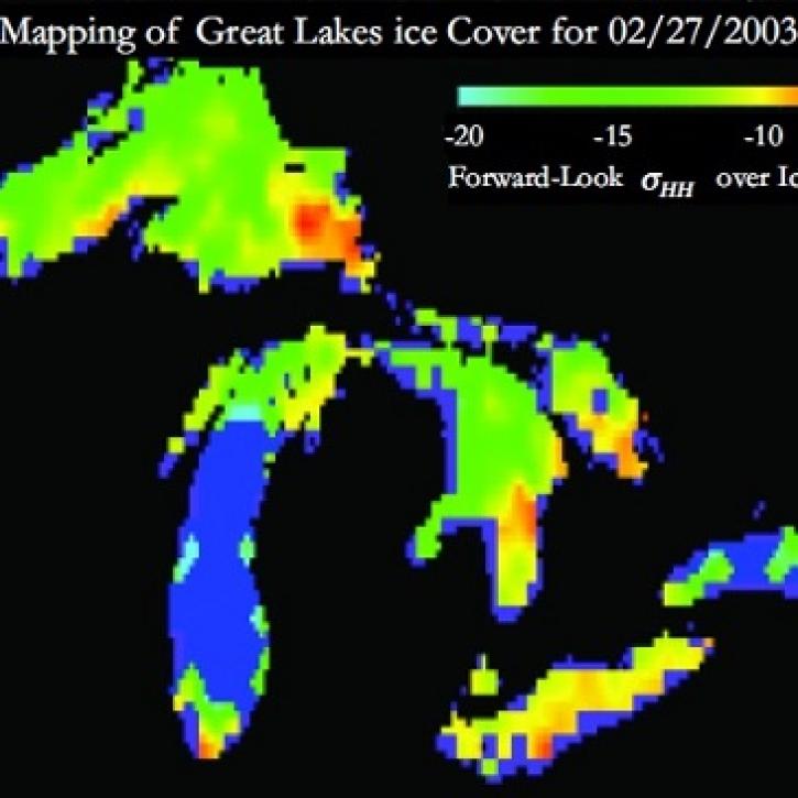
Understanding Great Lakes ice means enduring some tough conditions.
Feature Article
June 2, 2023

Image captured on May 29, 2023, by the MODIS instrument aboard the Terra satellite.
Worldview Image of the Week
June 1, 2023

Data from NASA’s Land Processes DAAC help Dr. Helen Poulos understand climate-induced change in the forests of the Southwestern U.S.
Data User Story
May 25, 2023

The May 23-25, 2023, online workshop will determine needs, evaluate current capabilities, identify gaps, and specify potential actions for NASA’s Terra, Aqua, and Aura mission data.
News
April 30, 2023

Data from NASA’s NSIDC DAAC help scientists like Dr. Fadji Z. Maina research hydrological change in High Mountain Asia.
Data User Story
April 27, 2023

The migration is part of NASA’s Earthdata Cloud Evolution, which gives users new ways to access NASA Earth science data.
News
April 14, 2023
SHOWING 8 OF 450
Frequently Asked Questions
Earthdata Forum
Our online forum provides a space for users to browse thousands of FAQs about research needs, data, and data applications. You can also submit new questions for our experts to answer.
Submit Questions to Earthdata Forumand View Expert Responses