We are in the process of migrating all NASA Earth science data sites into Earthdata from now until end of 2026. Not all NASA Earth science data and resources will appear here until then. Thank you for your patience as we make this transition.
Read about the Web Unification Project
StoryMaps
Esri StoryMaps created by NASA explore emerging Earth science data.
Filters
1 MIN READ
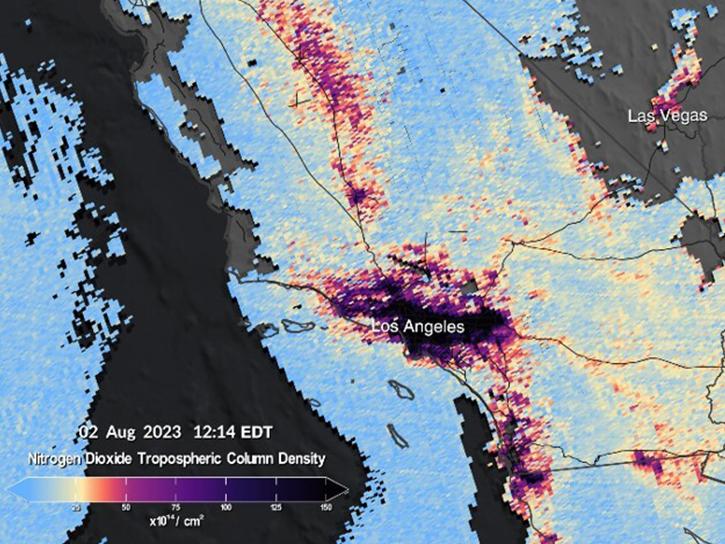
The TEMPO instrument, a cutting-edge venture by NASA, stands at the forefront of Earth observation technology for hourly AQ Observations.
Oct. 29, 2023

1 MIN READ
Work with Sentinel-1 Burst products from NASA’s Alaska Satellite Facility Distributed Active Archive Center (ASF DAAC).
June 14, 2023
1 MIN READ
This StoryMap highlights the Tropospheric Ozone Lidar Network (TOLNet) campaign, its goals, and its data products.
April 25, 2023


1 MIN READ
Getting SASSIE started means bringing folks – and lots of technology – from far and wide.
March 23, 2023

1 MIN READ
Key Findings from Ryoo et al.’s "Terrain Trapped Airflows and Precipitation Variability during an Atmospheric River Event"
March 23, 2023
1 MIN READ
Learn how to use the Global 30-m Height Above Nearest Drainage (HAND) dataset generated from the Copernicus GLO-30 DEM, from the image service published by NASA’s Alaska Satellite Facility Distributed Active Archive Center (ASF DAAC)
Dec. 2, 2022
1 MIN READ
Access enhanced image services for NASA's ASF Global Seasonal Sentinel-1 Interferometric Coherence and Backscatter dataset.
Dec. 1, 2022
SHOWING 8 OF 59