Announcing the EO Dashboard Hackathon Winners

Over 4,300 people competed in the Earth Observation (EO) Dashboard Hackathon. Find out which eight projects are Global Winners.
author-share

From June 23 to June 29, NASA joined with the European Space Agency (ESA) and Japan Aerospace Exploration Agency (JAXA) to host the Earth Observation (EO) Dashboard Hackathon. During this week-long, virtual event, more than 4,300 participants worked in teams to solve one of several challenges related to the COVID-19 pandemic using data openly available on the EO dashboard. The hackathon covered a wide range of topics, including air and water quality; economic, social, and agricultural impacts; greenhouse gas effects; and integrated Earth system impact.

This hackathon created a unique opportunity to showcase the tremendous capabilities of collaborative, open science at a global scale with participants from 132 countries and territories.

The Executive Judges recently chose Global Winners for the following awards:
  • Image
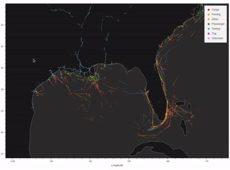
    The TRACER project used ship data, TROPOMI nitrogen dioxide data from ESA, and weather data to map the impact of COVID-19 on shipping-related air pollutants. TRACER won an Open Science Global Award.
    Open Science Award (two winners): These solutions best demonstrate the use of open science principles, which include transparency, inclusion, accessibility, and reproducibility:

    TRACER — an interactive satellite data portal that monitors ship activities to measure air pollution from nitrogen dioxide in regions near shipping lanes.
    CleverChart — a graphical interface that allows users to easily chart water quality changes and see the drivers of those changes.

  • Outreach Award: The solution that most creatively communicates the storytelling power of the EO Dashboard.

    Alliance for Action — a visualization of environmental injustice impacts of the COVID-19 pandemic for Los Angeles, California.

  • Data Award: The solution that maximizes the use of data from the EO Dashboard and leverages it to a unique application.

    Hackvengers — an analysis of the monthly changes in nighttime lights observed from satellites in order to understand how the COVID-19 pandemic affected the relocation of people around the San Francisco Bay area in California.

  • Technology Award: The solution that develops an innovative technical approach and is equipped for integration into the EO Dashboard.

    World MAQI — an interactive visualization of Mobility over Air Quality Index (MAQI), a measurement derived from fusing mobility statistics provided by Google with air quality data from satellite nitrogen dioxide observations.

  • Impact Award: The solution with the most potential to advance our knowledge of the effects of pandemics using the EO Dashboard.

    Wings of the West — a mobile application that visualizes endangered birds on the West Coast of the U.S. and relates bird populations to air quality parameters.

Global Winners will receive certificates presented by NASA, ESA, and JAXA and have the opportunity to integrate their findings into the EO Dashboard and the Euro Data Cube. They also receive five vouchers of $2,000 to spend over ESA’s Network of Resources (NoR) portfolio, an initiative to facilitate the use of EO data in cloud environments. Finally, winners are invited to attend a launch at one of NASA’s facilities once travel is deemed safe.

Image

In addition to the six global awards, JAXA and ESA provided two additional awards for teams that utilized specific datasets. The JAXA ALOS-2 Data Award was presented to The Developers project, which produced a website looking at the agricultural impacts of COVID-19, specifically on rice production in the Mekong River basin. This award was presented to the team that utilized data from JAXA’s Advanced Land Observing Satellite-2 (ALOS-2) effectively to achieve the goals of their challenge.

CleverChart, the Open Science Global Award winner, also won the ESA ESRIN Data Award that was presented to the team that utilized ESA data most effectively to achieve the goals of their challenge. ESRIN, known as the ESA Centre for Earth Observation, is the headquarters for ESA's Earth Observation activities.

The COVID-19 pandemic offered an unprecedented opportunity to look at changes in the Earth system in response to reduced human activity and travel. The hackathon was a successful demonstration of how researchers can leverage open data to come up with innovative solutions to pressing problems at the global scale. Participants were required to conduct their research in a way that was transparent and reproducible, and teams were required to publish their code on GitHub.

Find out more about the Global Winners and all of the projects created during the hackathon on the EO Hackathon website.

Last Updated