NASA and CEOS Team Up to Provide New Data User Communities with COVERAGE

CEOS' online platform makes it easier for new users to find, visualize, and analyze remotely sensed and in-situ data on marine ecosystems.
author-share
Image

For less experienced users of Earth observation data, sifting through scores of ocean data from multiple agencies to find the right dataset for a particular application can be a daunting task. With so many datasets available, it can be hard for users to find and decide which products best meet their needs. And then there’s the process of accessing, visualizing, or analyzing data, all of which are more difficult than they ought to be given heterogeneous mechanisms of data discovery and access across different agency repositories. What’s a new data user to do?

Well, if that user is searching for data on ocean parameters, he or she could look to the Committee on Earth Observation Satellites’ (CEOS) COVERAGE initiative. COVERAGE is an acronym for CEOS Ocean Variables Enabling Research and Applications for GEO (Group on Earth Observations) and the COVERAGE initiative is a collaborative effort to implement an online platform providing simpler, more integrated access to in-situ and satellite data on key parameters pertaining to the four ocean virtual constellations—sea surface temperature, ocean vector winds, ocean surface topography, and ocean color radiometry—in support of marine science and applications prioritized by community stakeholders. In doing so, COVERAGE leverages and seeks to further refine emerging cloud-based technology solutions for data platform implementation and produce a reusable, open-source software stack that can be easily deployed in different contexts to support a range of thematic applications involving the integration of multivariate ocean observations. Funded by NASA’s Earth Science Data Systems (ESDS) and Physical Oceanography (PO) Programs and with contributions from CEOS agency partners, technical implementation of COVERAGE is occurring in a phased manner by the project team based at NASA's Jet Propulsion Laboratory (JPL).

Image
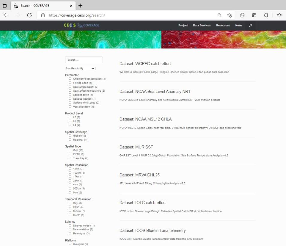
COVERAGE’s search interface simplifies the process of data discovery to help new or inexperienced data users get the data that meet their needs. Credit: COVERAGE.

At the same time, it was also created to promote the use of remotely sensed ocean data among emerging communities that could benefit from satellite environmental observations but may not know how to obtain or work with such data.

“COVERAGE is geared toward users who may be new to working with remotely sensed data and who may be experiencing some challenges in selecting data products and working with data,” said Dr. Vardis Tsontos, systems engineer at JPL and COVERAGE project lead. “We’re trying to lower the bar of entry—to reduce the technical obstacles to using these data for both research and decision support applications—by providing a useful toolkit and curated, high-value data sets. Of course, more experienced users as well should find great value in the novel data visualization and analytics capabilities that COVERAGE provides.”

According to CEOS, ocean science datasets are proliferating at such a rapid pace that there is now a need for improved data service infrastructure to showcase their utility and more fully realize the potential of Earth observations. COVERAGE was designed to provide a value-added service layer based on a distributed hybrid cloud architecture that builds on existing agency data infrastructures.

“One of the key issues with respect to COVERAGE is the integration of the disciplines with the wider remote sensing community,” said Jorge Vazquez, a research scientist at JPL, and COVERAGE deputy project lead. “The integration of the satellite data and the in-situ data will offer more of a multidisciplinary approach to users looking to access ocean data and allow decision makers to better understand impacts of climate and the societal benefits these applications can provide.”

This interdisciplinary, multiparameter approach makes COVERAGE a complement to NASA’s discipline-specific Distributed Active Archive Centers (DAACs), which process, archive, and distribute data from NASA's past and current Earth observing satellites and provide additional tools and resources to support data-users in a range of disciplines. Therefore, among the goals of this approach is a focus on datasets deemed critical for thematic applications so users avoid having to become experts in all the data.

Image
Map of the distributed architecture and network of collaborating data providers that inform the COVERAGE system. Credit: CEOS.

Data from NASA’s Physical Oceanography DAAC (PO.DAAC) are among the datasets included in COVERAGE’s offerings. However, “COVERAGE deals with interagency datasets, not just NASA data, and focuses on providing what the research community considers to be high-value data products useful for a wide range of end-user applications,” said Tsontos. Therefore, COVERAGE datasets do not include lower-level data (e.g., Level 1 and 2) that a science team might use. Rather, they are the more processed, higher-level (e.g., Level 3 and 4) gridded, merged, and multi-instrument datasets from NASA and its international partners. These higher-level data sets target the applications and research communities, as well as decision makers.

“We absolutely don’t want to provide everything because that’s one of the challenges that less experienced data users face, ‘Which product should I select?’” Tsontos said. “Based on expert and community inputs, we have curated a set of fit-for-purpose data products for them in COVERAGE.”

In instances where Level 4 datasets for ocean parameters are found to be lacking, the COVERAGE project team has pursued their own development. Currently, the COVERAGE project is developing and validating a gap-free, multi-mission, high resolution Level 4 chlorophyll-A ocean color dataset, which is a critical product for assessing the condition and productivity of the ocean.

In addition to pulling together the most widely used datasets for each of the four ocean science parameters, COVERAGE also makes it easier for less experienced Earth science data users to not only find but get the data they want.

“COVERAGE is also trying to reduce the technical barriers to accessing data,” said Tsontos. “The mechanics of getting data from different agency repositories varies considerably, so there is a complex, heterogeneous landscape of data acquisition that users currently have to navigate. They have to become familiar with different systems and tools that are supported by the different archives to get what they want once they’ve actually figured out and found what they want. This is time consuming and detracts focus from the science problem that needs to be addressed.”

COVERAGE is doing that, says Tsontos, by “providing a more consistent and user-friendly interface that hides the mechanics.”

COVERAGE is being developed in phases. The COVERAGE initiative was first proposed and then discussed within CEOS prior to approval in 2017. The roughly nine-month Phase-A activity involved requirements gathering based on stakeholder consultations, designing the system’s architecture, reviewing, and deciding upon constituent data products and defining a thematic application used to demonstrate the system’s capabilities. Phase B of the project—prototype development—began in late 2019 and concluded in December of 2020. Phase C implementation started in June 2021. During this installment, the COVERAGE team plans to extend the prototype to an operations-grade capability with additional functionality that provides an enhanced the user experience.

However, users need not wait until the conclusion of Phase C to experience COVERAGE. They can explore the platform at https://coverage.ceos.org/ and experience its data search, visualization, and analytics services now. For example, clicking on the Search link (under the Data Services heading in the top-level navigation) brings users to the interface that allows them to choose from a list of parameters and ultimately zero-in on the dataset that best meets their needs. The interface also offers the data product metadata directly from its source, be it PO.DAAC, Copernicus, or another data center. Once a dataset is selected, users are provided with a description, along with links to supporting documentation, data service endpoints and links, and the location where the data are archived.

The Visualization link (also under the Data Services heading) brings users to the COVERAGE Data Viewer, which allows users to explore in-situ and satellite data separately or together. Users can also set up animations to observe dynamic changes and the evolution of data over time data both as maps and coupled plots that can be interactively defined and shared with colleagues.
Image
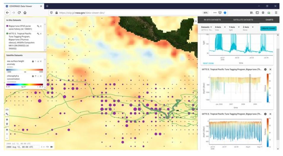
This screen capture from the COVERAGE Data Viewer shows how in-situ data on tuna populations and satellite data can be used together to inform research on marine ecosystems. The figure shows time dynamic maps IATTC Bigeye Tuna archival tag and spatial catch distribution data relative to AVISO-Sea Surface Height Anomaly imagery with customizable charts that display animal telemetry environmental measurements as time series and depth profile plots of different kinds. The tool provides tightly synchronized views of mapped and charted, and precise control of time intervals of stepping and animation of data displays. Credit: COVERAGE.

COVERAGE additionally allows users to conduct a range of analytic functions, including “creating and running scripts of their own,” said Tsontos.

“The Science Data Analytics Platform (SDAP) tool in COVERAGE has built-in analytic functions providing cloud-based parallel computing capabilities,” he said. “The sets of analytics already built into the SDAP will execute quickly, but users can apply other analysis capabilities available through python libraries to perform other custom operations.”

Beyond the services pertaining to data search, visualization, and analytics, COVERAGE also offers open-source software, documentation, and media resources, including instructional videos on how to use the SDAP analytics tool and its web-based tool for integrated visualization of oceanographic in-situ and satellite data. In addition, users can find detailed information pertaining to COVERAGE’s approach to aggregating and providing in-situ and satellite data, data product development, system architecture, software, and the cloud infrastructure it relies on. There is also an up-to-date news and events section featuring the latest announcements from the project and that links to posts from the COVERAGE Twitter feed and video content from the COVERAGE YouTube channel.

Yet, despite the array of data services and informational resources offered on the platform, Tsontos and Vazquez would remind users that, in its current form, COVERAGE is still a work in progress.

“[COVERAGE] is still in development and evolving. We are trying to harmonize and achieve interoperability across these different data systems and leverage cloud capabilities that are still emerging. This is a non-trivial problem,” Tsontos said. “So, although COVERAGE is publicly available, it is still a prototype. As part of our Phase-C project that is now under way, we’ll be releasing new capabilities as we have them via the same portal that’s been established online.”

Image
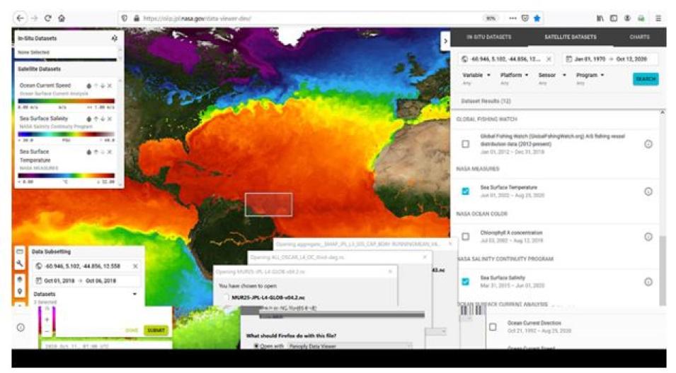
Output from the COVERAGE Viewer tool showing its integrated dataset search and filtering features, and its 'one-stop" dataset subsetting and download capability for both selected satellite and in-situ datasets within the application. Credit: COVERAGE.

Currently, COVERAGE’s design demonstrates its potential to use both remotely sensed satellite and in-situ data in support applications pertaining to marine biodiversity and fisheries, as there is a need for a better and more integrated approach to addressing a range of marine ecosystem assessment and monitoring applications in support of the GEO Marine Biodiversity Observations Network (GEO-MBON), GEO Blue Planet, and other international initiatives related to the United Nations (UN) Sustainable Development Goals (SDGs).

In 2015, all UN Member States adopted the UN’s 2030 Agenda for Sustainable Development, which offers “a shared blueprint for peace and prosperity for people and the planet, now and into the future.” That blueprint consists of 17 SDGs, including Goal 14: Conserve and sustainably use the oceans, seas, and marine resources for sustainable development.

COVERAGE was conceived with this sustainable development goal in mind, but Tsontos and his colleagues are keen to demonstrate that COVERAGE’s approach to offering a combination of satellite and in-situ data is amenable to other environmental applications.

“There’s a biological focus to this currently, but we’d like to be able to generalize it in such a way that it could be used to support other applications as well,” Tsontos said. “We can provide a reusable toolkit that can be spun up quickly and used for different thematic applications beyond the current biological focus and that use different NASA and in-situ datasets.”

According to Tsontos, COVERAGE will feature other applications that have a focus on physical oceanography later in Phase C. The project team is also considering implementation of some more focused regional ecosystem applications as well in collaboration with project partners at the Sargasso Sea Commission and Inter-American Tropical Tuna Commission.

Yet, whatever the application, the overarching goal of COVERAGE remains helping new and less experienced data users locate, access, and use multidisciplinary remote sensing data. By making remote sensing data more easily accessible to a broader range of users it advances NASA’s Open Science and Open Data priorities.

“I don’t think expert users would necessarily rely on COVERAGE for their purposes, although some of its advanced capabilities could be of interest to them as well,” said Tsontos. “But there are a lot of people who need NASA data products and might be struggling. We want to help them, and in the process ensure that the uptake and potential of these valuable Earth observation datasets is more fully realized.”

Last Updated