Introduction

Data products distributed by the Land Processes Distributed Active Archive Center (LP DAAC) are used in many different Earth science applications. They play an important role in modeling, helping to detect changes to the landscape, and assessing ecosystem variables, to name a few. Three of those applications, published between April and June 2018, are highlighted below. A more comprehensive list is available on the LP DAAC Publications webpage.

MODIS and Dust Reduction in the North China Plain

In a paper "Effect of ecological restoration programs on dust concentrations in the North China Plain—A case study" published by Xin and others in Atmospheric Chemistry and Physics, the authors set out to study the impact ecological restoration programs have on the spreading of dust in the North China Plain.

Image
Image Caption

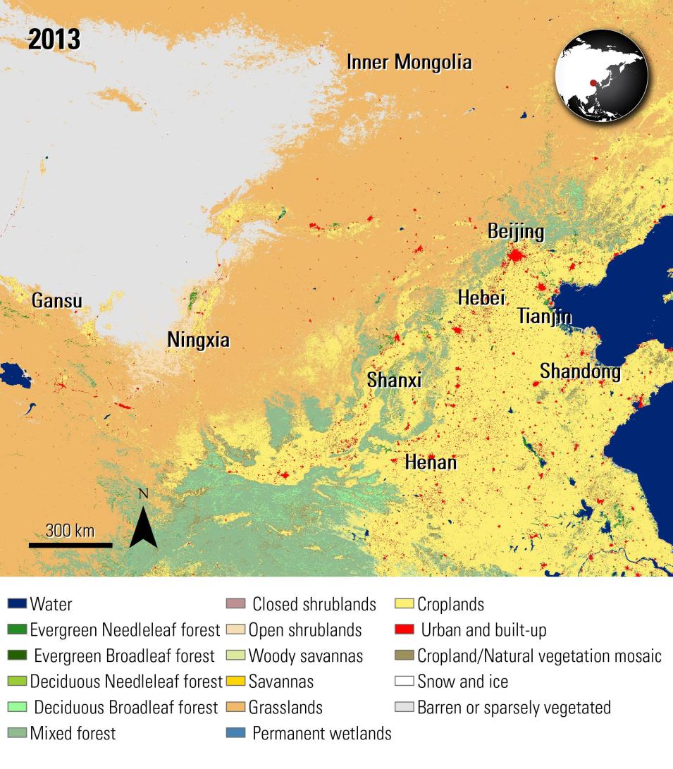
A view of the study area from Xin and others (2018) showing the IGBP land cover classification from the Combined Terra and Aqua MODIS Land Cover data product for the year 2013. On the North China Plain, dust storms originate from Inner Mongolia, Ningxia, Gansu, and Shanxi. The dust typically settles near the densely populated areas, including Beijing, Hebei, Henan, Tianjin, and Shandong.

Science Objectives

The authors aimed to understand how ecological restoration programs programs, including the Great Green Wall, have changed the land cover of the area between 2001 and 2013 and how these changes impact dust concentrations. They also sought to understand the behavior of dust during a major 2006 dust storm in relation to these land cover changes.

Instruments and Techniques Used

The authors used the International Geosphere Biosphere Programme (IGBP) land cover classification information, derived from the Terra and Aqua Combined Moderate Resolution Imaging Spectroradiometer (MODIS) Land Cover data product (MCD12Q1), to look at land cover changes. They also used dust data from China’s Ministry of Environmental Protection to study dust behavior. For modeling the impact of land cover changes on dust concentrations, they used the Weather Research and Forecast (WRF)-dust model, combining it with the MODIS land cover data and the dust data.

Major Findings

Based on the MODIS land cover data, the authors found that vegetation increased and transitions occurred from bare soil to grasslands and savannas between the dust storm source areas and the eastern populated provinces. The MODIS data also showed an increase in forests near these eastern provinces. Using the WRF-dust model, the authors found that the ecological restoration programs helped in reducing dust concentrations in the study area, particularly in Beijing, Tianjin, and Hebei, with an estimated 5 to 15 percent reduction in dust particulate matter during the 2006 storm. The authors believe this dust reduction positively contributed to controlling air pollution in the area.

References

Publication Reference

Xin, L., Tie, X., Li, G., Cao, J., Feng, T., Zhao, S., Xing, L., and An, Z., 2018, Effect of ecological restoration programs on dust concentrations in the North China Plain—A case study: Atmospheric Chemistry and Physics, v. 18, no. 9, p. 6353–6366.doi:10.5194/acp-18-6353-2018

Image Reference

Granule ID:

  • MCD12Q1.A2013001.h(#)v(#).051
  • h23 to 29 and v 3 to 7
     

ASTER and Landsat for Geology Mapping in Northern Victoria Land

In a paper by Beiranvand Pour and others, "Regional geology mapping using satellite-based remote sensing approach in Northern Victoria Land, Antarctica" published in Polar Science, the authors explore a satellite-based remote sensing approach to map the geology of Northern Victoria Land, Antarctica, at the geological terrane level.

Image
Image Caption

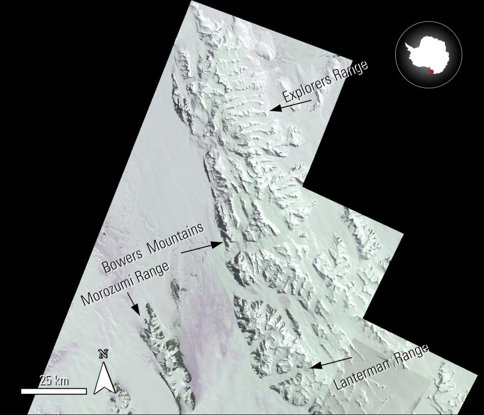
A Terra ASTER mosaic of the study area from Beiranvand Pour and others (2018) research. This mosaic uses ASTER scenes from 2003, 2005, and 2006, as identified in the article. The authors use band ratios from this data product to study the different mineral compositions in the area.

Science Objectives

The authors aimed to develop a method for mapping the regional geology of Northern Victoria Land, Antarctica, using satellite-based remote sensing data. Their objective was to utilize data from the Terra Advanced Spaceborne Thermal Emission and Reflection Radiometer (ASTER) and Landsat 8 to identify and map different geological features and mineral compositions across this remote and largely inaccessible region.

Instruments and Techniques Used

The authors used the Terra ASTER Level 1 Precision Terrain Corrected (AST_L1T) data product along with data from Landsat 8. They developed several spectral-band ratios to map snow and ice and different types of minerals, including iron oxide/hydroxide and quartz-rich felsic materials. These ratios were applied to create mosaicked maps from both ASTER and Landsat data to highlight mineral locations and geological structures. The results were verified using GPS surveys from geological expeditions, existing geological maps, and laboratory XRD analysis.

Major Findings

The research successfully developed spectral-band ratios that effectively mapped snow, ice, and various minerals in Northern Victoria Land. The mosaicked maps created from ASTER and Landsat data provided a comprehensive view of mineral distribution and geological structures across the study area. The verification process confirmed the accuracy of the remote sensing-based mapping. The authors concluded that the developed band ratios are valuable for geological mapping in other inaccessible regions and anticipate that ASTER and Landsat data will continue to provide increasingly comprehensive geological information at various scales.

References

Publication Reference

Beiranvand Pour, A., Park, Y., Park T., Kuk Hong., Hashim, M., Woo, J., and Ayoobi, I., 2018, Regional geology mapping using satellite-based remote sensing approach in Northern Victoria Land, Antarctica: Polar Science, v. 16, p. 23–46. doi:10.1016/j.polar.2018.02.004

Image Reference

  • Granule IDs:
    • AST_L1T_00301022005221353_20150507182028_120722
    • AST_L1T_00312022006215539_20150517071229_106619
    • AST_L1T_00312022006215530_20150517071229_106617
    • AST_L1T_00301012003215105_20150426142100_98011
    • AST_L1T_00301022005221335_20150507182018_120402
    • AST_L1T_00301022005221344_20150507182018_120405
  • DOI: 10.5067/ASTER/AST_L1T.003

MODIS NDVI and PhenoCam for Australian Grassland Productivity

According to Marchin and others in their article titled "Productivity of an Australian mountain grassland is limited by temperature and dryness despite long growing seasons" published in Agricultural and Forest Meteorology, more research is needed on the impacts of climate change in the Southern Hemisphere. In this paper, the authors examine long-term changes (2001–2016) in the phenology and productivity of Nimmo, an Australian montane grassland.

Image
Image Caption

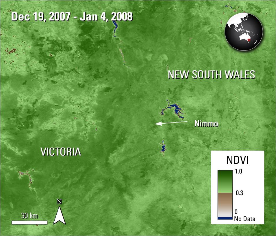
Nimmo and the surrounding area is shown in this Terra MODIS 16-day NDVI image. NDVI is used to study the health of vegetation. In this study it was used to observe long term vegetation changes throughout the montane grassland.

Science Objectives

The authors aimed to investigate the long-term changes in the phenology and productivity of a montane grassland in Australia in relation to climate. They specifically sought to characterize the seasonal phenology patterns, determine the length of the growing season, and assess the correlation between growing season length and vegetation productivity. Additionally, they aimed to understand how temperature and rainfall influence different phenological stages.

Instruments and Techniques Used

The authors utilized the Normalized Difference Vegetation Index (NDVI) layer of the Terra Moderate Resolution Imaging Spectroradiometer (MODIS) Vegetation Indices data product (MOD13Q1) to characterize seasonal phenology patterns. They also used climate data from other sources. To record vegetation greenness at a near-surface level, they employed repeat digital photography (PhenoCam). The MODIS NDVI data were then compared to the greenness index derived from the PhenoCam imagery to assess agreement between the two methods.

Major Findings

The authors found that the mean growing season length in the study area was 244 days, longer than in the Northern Hemisphere, with peak NDVI in December. However, this longer growing season did not correlate with increased vegetation productivity. The green-up of the grassland started earlier over the study period, likely due to increased late winter temperatures. While senescence, peak NDVI date, and growing season length did not show significant long-term changes, they were impacted in different years by temperature and rainfall. 

The MODIS NDVI data and PhenoCam imagery showed agreeing results, suggesting that satellite data can be used to extend PhenoCam records in the future. The study concluded that the productivity of this Australian mountain grassland is limited by temperature and dryness despite its long growing season.

References

Publication Reference

Marchin, R., McHugh, I., Simpson, R., Ingram, L., Balas, D., Evans, J., and Adams, M., 2018, Productivity of an Australian mountain grassland is limited by temperature and dryness despite long growing seasons: Agricultural and Forest Meteorology, v. 256–257, p. 116–124. doi:10.1016/j.agrformet.2018.02.030

Image Reference

  • Granule IDs:
    • MOD13Q1.A2007353.h29v12.006.2017285170244
    • MOD13Q1.A2007353.h30v12.006.2017285170311
  • DOI: 10.5067/MODIS/MOD13Q1.006

Details

Last Updated

Published

Data Center/Project

Land Processes DAAC (LP DAAC)