Science Objectives
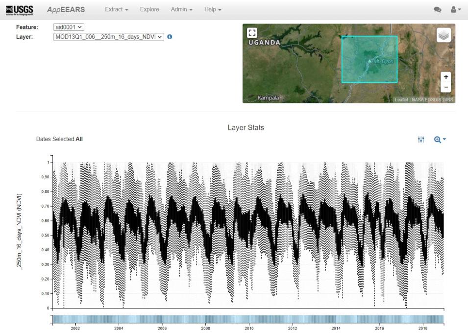
Expanding populations lead to a higher demand for food and natural resources, which drive agricultural and other land cover/land use changes (LCLUC) in many regions of the world. In regions with high interannual climate variability and a dependence on rainfed agriculture, this can be a recipe for severe food insecurity. There is a need to better understand the long term impacts of climate change and shorter term impacts of anthropogenic activities (i.e. LCLUC) on vegetation trends (greening/browning) to inform policy decisions that can help conserve the environment and improve communities that depend on it. The Mt. Elgon ecosystem (MEE) straddles the border between Uganda and Kenya and was recently studied by Wanyama and others (2020) to characterize greening/browning trends in vegetation on a multi-temporal scale from 2001–2018.
Instruments Used
The researchers investigated spatio-temporal patterns in NDVI data from the Terra MODIS Vegetation Indices 250 meter (m) 16-day composited product (MOD13Q1.006) at multi-temporal scales (10-day, 16-day, and seasonal) using an integration of Mann-Kendall, Sen’s slope, and the Breaks for Additive Season and Trend (bfast) algorithms. They included precipitation data from the Climate Hazards Group Infrared Precipitation with Stations data product to disentangle human-driven vs. natural vegetation changes. Combined Terra and Aqua MODIS Annual Land Cover Type (MCD12Q1.006) data from 2018 was also used to classify land cover types in the region. The MODIS NDVI data were extracted using NASA’s Application for Extracting and Exploring Analysis Ready Samples (AppEEARS). The authors describe performing a quality assessment of the MODIS NDVI data using the quality layer to exclude poor quality pixels from the analysis.
Major Findings
After applying the integrated Mann-Kendall, Sen’s slope, and bfast algorithms on the time series, the authors found that vegetation in the MEE is highly variable, with greening and browning being observed at all time scales. Using multiple algorithms helped detect different changes. The Mann-Kendall and Sen’s slope approach revealed major changes related to forest gain/loss, while the bfast approach observed more subtle changes, including vegetation degradation. The authors found that certain changes could be attributed to natural (precipitation) and anthropogenic (particularly vegetation to cropland LCLUC) factors. This work characterizes MEE vegetation dynamics, which can inform policy decisions that will both help conserve the environment and protect the livelihoods of the communities dependent on this region for agriculture.
References
Publication Reference
Wanyama, D., Moore, N.J., and Dahlin, K.M., 2020, Persistent vegetation greening and browning trends related to natural and human activities in the Mount Elgon ecosystem: Remote Sensing, v. 12, no. 13, art. no. 2113. doi:10.3390/rs12132113.
Image References
AppEEARS Team, 2020, Application for Extracting and Exploring Analysis Ready Samples (AppEEARS), Ver. 2.48: NASA EOSDIS Land Processes DAAC, accessed November 4, 2020, at https://appeears.earthdatacloud.nasa.gov/.
Didan, K., 2015, MOD13Q1 MODIS/Terra Vegetation Indices 16-Day L3 Global 250m SIN Grid V006: NASA EOSDIS Land Processes DAAC, accessed October 28, 2020, at doi:10.5067/MODIS/MOD13Q1.006.
Fuel Moisture in Fire-Prone Shrublands
In the study "Investigating Live Fuel Moisture Content estimation in fire-prone shrubland from remote sensing using empirical modelling and RTM simulations" published in Remote Sensing, Marion and others (2020) use MODIS and Sentinel-2 data to estimate live fuel moisture for wildfire risk modeling in Central Spain.

