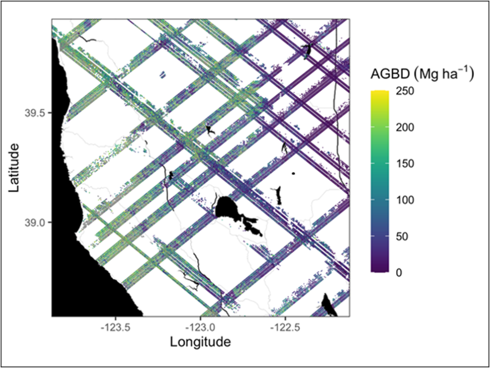
NASA's Oak Ridge National Laboratory Distributed Active Archive Center (ORNL DAAC) released new footprint aboveground biomass density (AGBD) data from the Global Ecosystems Dynamics Investigation (GEDI). These data—the first since the instrument resumed operations in April 2024—provide mapped predictions of AGBD in Megagrams per hectare (Mg/ha) and estimates of the uncertainty within each sampled geolocated laser footprint. The data are available as the GEDI Level 4A data product.
GEDI Is Back Online With an Updated Release of Footprint Aboveground Biomass Density
“From March 2023 to April 2024, the GEDI instrument was stored on the International Space Station (ISS), resulting in a temporary suspension of data acquisition,” said Dr. Rupesh Shrestha, a research staff member at ORNL DAAC. “This update marks the first update to the GEDI Level 4A dataset since its redeployment. The current update incorporates Level 4A granules collected from April 2024 through November 2024.”
GEDI launched to the International Space Station (ISS) on December 5, 2018, and began collecting data in April 2019. After sitting in storage for 13 months to accommodate another instrument aboard ISS, the instrument was returned to its original spot and resumed normal operations without incident or impact to data quality.
“This mission was originally planned to last for 2 years but is now in its second extension. The fact that instrument is functioning so well, especially after a year in hibernation, is a testament to both the team that designed the instrument and those who continue to steward it,” said Talia Schwelling, Administrative and Outreach Coordinator for the GEDI mission.
With the accumulation of GEDI data during the post-storage period, the mission will vastly increase the amount of information available for mapping and monitoring forests and woodlands in the United States and worldwide. An important new application is the use of GEDI data to directly measure changes.
"Extending the mission into the post-storage period opens up a whole new set of applications that are both scientifically and societally important," said Schwelling. "Now we can directly measure how forests evolve after disturbances, such as from fires. This helps us manage these resources across a range of applications, from timber harvesting to habitat conservation."
About the GEDI Mission
GEDI is led by the University of Maryland in collaboration with NASA's Goddard Space Flight Center in Greenbelt, Maryland. The purpose of the mission is to map forests and woodlands, including how they are changing over time. Understanding how forests and woodlands vary geographically improves scientific understanding of important atmospheric and water cycling processes and contributes to better knowledge about the risks of catastrophic fires and floods.
The GEDI instrument consists of 3 lasers producing a total of 8 ground transects, which consist of 25-meter footprint samples spaced approximately every 60 meters along-track. GEDI beam transects are spaced approximately 600 meters apart on Earth’s surface in the cross-track direction, for an across-track width of about 4.2 kilometers.
GEDI Version 3 Data Coming Soon
In addition to the release of the version 2.1 dataset, the Science Operations Center at NASA Goddard has initiated the processing of Version 3.0 GEDI data, which are anticipated to be available later in 2025. The version 3.0 updates include improvements to geolocation accuracy and changes to waveform processing. The horizontal geolocation performance in Version 3.0 GEDI data is 10 meters (one sigma), a 3.5 meter improvement in comparison to Version 2.0, according to Scott Luthcke, a geophysicist at NASA Goddard and a member of the GEDI Science Team.
There are also improvements to vertical geolocation performance. “We’ve been able to standardize performance across mission weeks, including vertical elevation geolocation across the GEDI time series,” Luthcke said, noting that this addresses some inconsistencies in Version 2.0 GEDI data.
The version 3.0 update will also strengthen the algorithms being used to develop the Level 4A data product. The most important update flows from work done by the GEDI Science Team to increase the amount of information available to calibrate the Level 4A algorithms. “We’ve prioritized calibration data in the United States,” said Jim Kellner, a professor at Brown University, GEDI co-Investigator, and member of the GEDI Science Team.
Kellner added that between Version 2.1 and 3.0, the GEDI Science Team added more calibration data in the United States than in the rest of the world combined. “We nearly doubled the number of measurements available in U.S. forests,” Kellner said, “and we’re looking forward to publicly releasing the update later this year.”
Data Access
Users can access GEDI Level 4A data via ORNL DAAC and the NASA Earthdata Cloud, which provides the opportunity to access and process large quantities of data and promotes innovation around new services, such as sequencing data to support machine learning and artificial intelligence. GEDI data are also available through Earthdata Search and a variety of NASA Earthdata tools and services, including OPeNDAP and Harmony.
Learning Resources
GEDI Level 4A data will be available for subsetting in ORNL DAAC’s Global Subsets Tool, which allows users to select a location and get subsets and time series visualizations covering up to 200 km x 200 km for the selected NASA data products.
Learn more about how to access and use GEDI data:
