
NISAR L-Band Data Released, Expanding Record of Surface Changes

Produced by NASA JPL for the NISAR mission, these data products give researchers a new way to observe changes across Earth’s surface.

Calibrated L-band data from the NASA-ISRO Synthetic Aperture Radar (NISAR) mission are now available through the Alaska Satellite Facility Distributed Active Archive Center (ASF DAAC) and NASA Earthdata. The initial public release, which began July 20, 2026, includes observations acquired on or after June 17, 2026.

New acquisitions will be added as they are processed, providing researchers with an expanding record of Earth's changing surface. Earlier observations collected during NISAR's first year of science operations will continue to be added over the coming months, with the complete science record expected to be available by the end of 2026.

Image
Image Caption

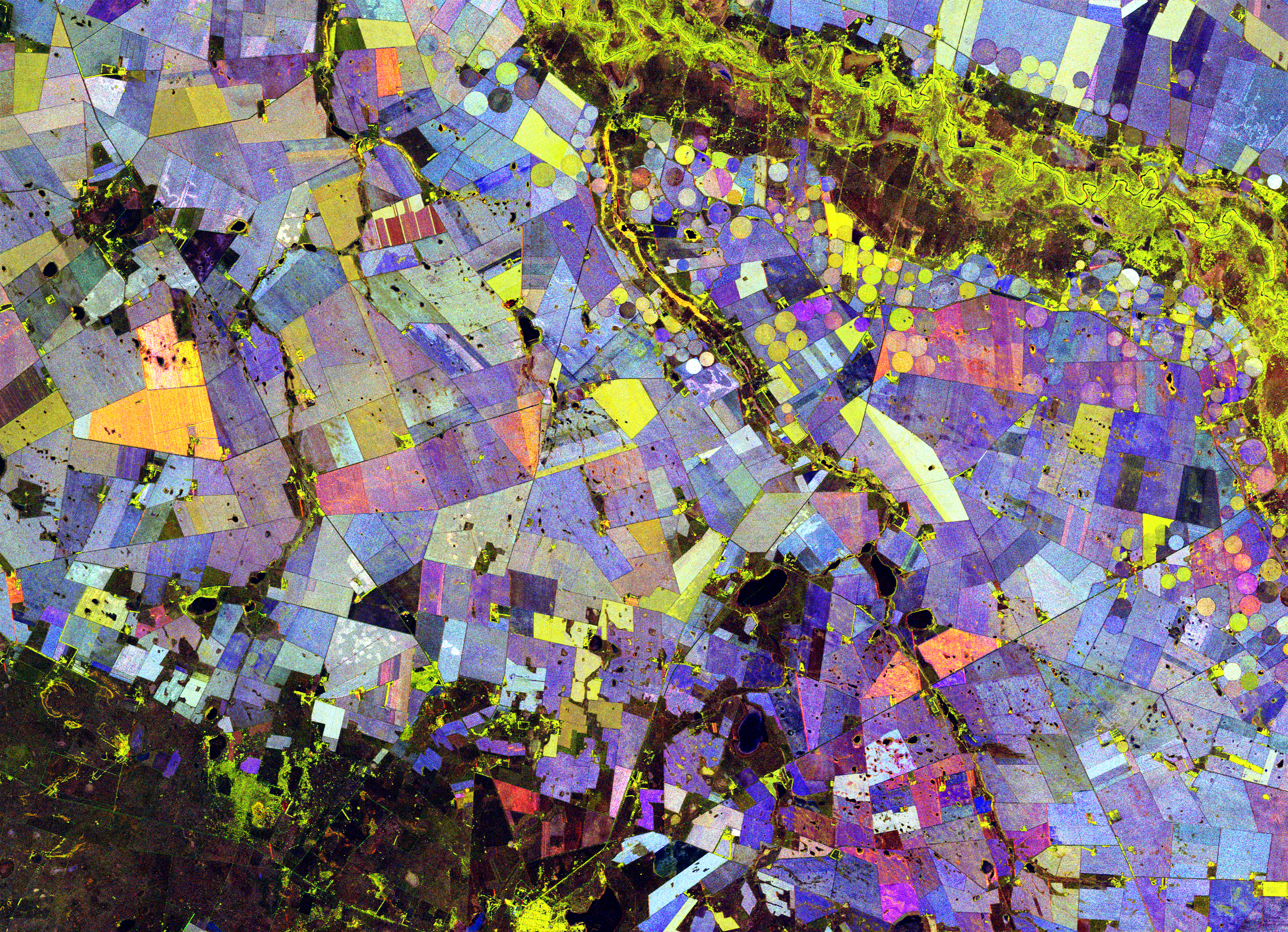
This false-color composite derived from NISAR data highlights vegetated areas (green), unvegetated surfaces (red), and how rapidly the vegetated areas changed (blue) during the 2025-2026 growing season in an agricultural region of South Africa. Most pixels contain a mix of these colors, producing the visualization’s a varied color palette.

Accessing the Data

NISAR products can be discovered through NASA Earthdata Search or explored in the ASF Vertex data search tool. Both provide access to data by location, acquisition date, and product type, allowing researchers to quickly identify and download observations for analysis. For automated workflows and large-scale processing, ASF also provides access through its APIs and the asf_search Python package.

Why L-Band?

NISAR is the first joint satellite mission between NASA and the Indian Space Research Organisation (ISRO), combining L-band and S-band radar systems designed to provide a detailed view of Earth's changing surface. 

The mission's L-band radar, built by NASA JPL, operates at a 10-inch (25-centimeter) wavelength. With a longer wavelength than many spaceborne radar systems, the L-band radar can detect features that shorter wavelengths often cannot. It penetrates vegetation canopies and, under certain conditions, snow and ice, providing information that is not visible in optical imagery alone. These capabilities make L-band particularly valuable for studying forests, wetlands, glaciers, ice sheets, ground deformation, and other subtle changes across Earth's surface.

The mission's scientific value extends beyond individual observations. By repeatedly imaging the same locations twice every 12 days, even through cloud cover, NISAR will build a consistent, long-term record of surface change that supports research on glacier dynamics, land subsidence, natural hazards, ecosystem change, and other processes that evolve over time.

As NASA's archive for synthetic aperture radar data, ASF DAAC makes NISAR products available alongside decades of SAR observations from past and current missions. All NISAR L-band products are distributed free of charge through ASF DAAC and NASA Earthdata.
Image
Image Caption

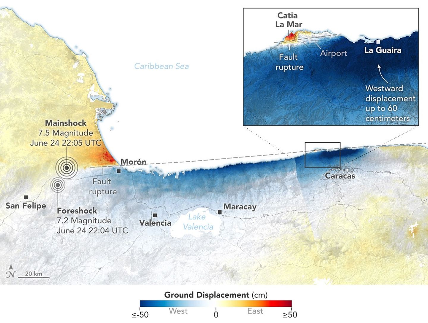
Areas of Venezuela experienced significant ground displacement from two earthquakes on June 24, 2026. Ground displacement was especially intense near Caracas and La Guaira, Venezuela. The map was derived from NISAR data acquired on June 25 and June 30 (after the earthquakes) and June 13 and June 18 (before the earthquakes). Credit: NASA Earth Observatory/Lauren Dauphin

Learn More

Explore the data, documentation, and tools available for working with NISAR:

Read more about the data release and a compelling visualization of NISAR data in US-India Satellite Delivers Data, Reveals ‘Hummingbird’ in Antarctica.

Details

Last Updated

July 21, 2026

Published

July 21, 2026

Data Center/Project

Alaska Satellite Facility DAAC (ASF DAAC)