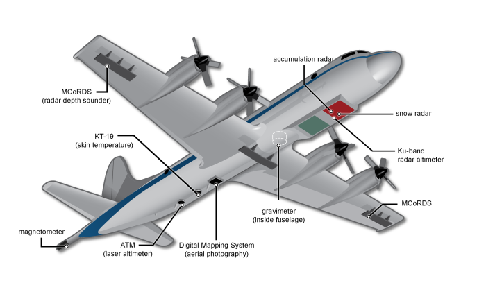
| Name | Spatial Coverate | Temporal Coverate | Parameters |
|---|---|---|---|
| CryoSat-2 Level-1B Waveforms, Sea Ice Elevation, and Surface Roughness, Version 1 (RDWES1B) | N:90, S:55, E:180, W:-180 | September 15, 2010, to present | Sea Ice Elevation Surface Roughness |
| CryoSat-2 Sea Ice Freeboard, Thickness, and Snow Depth Quick Look, Version 1 (NSIDC-0707) | N:90, S:55, E:180, W:-180 | March 1, 2014 - March 31, 2014 March 1, 2015 - March 31, 2015 | Freeboard Ice Depth/Thickness Ice Roughness Sea Ice Concentration Snow Density Snow Depth |
| IceBridge Accumulation Radar L1B Geolocated Radar Echo Strength Profiles, Version 1 (IRACC1B) | N:90, S:60, E:180, W:-180 | May 6, 2010 - May 7, 2012 | Glacier Topography/Ice Sheet Topography Radar Imagery Sea Ice Elevation Snow Cover |
| IceBridge Accumulation Radar L1B Geolocated Radar Echo Strength Profiles, Version 2 (IRACC1B) | N:90, S:60, E:180, W:-180 N:-53, S:-90, E:180, W:-180 | March 21, 2013 - May 1, 2018 | Glacier Topography/Ice sheet Topography Radar Imagery Sea Ice Elevation Snow Cover |
| IceBridge ARES L1B Geolocated Radar Echo Strength Profiles, Version 1 (IRARES1B) | N:63, S:56, E:-129, W:-157 | August 26, 2015 - May 13, 2021 | Radar Imagery |
| IceBridge ATM L1B Elevation and Return Strength with Waveforms, Version 1 (ILATMW1B) | N:90, S:60, E:180, W:-180 N:-53, S:-90, E:180, W:-180 | July 17, 2017 - November 20, 2019 | Glacier Elevation/Ice Sheet Elevation Sensor Counts |
| IceBridge ATM L1B Elevation and Return Strength, Version 2 (ILATM1B) | N:90, S:60, E:180, W:-180 N:-53, S:-90, E:180, W:-180 | March 20, 2013 -November 20, 2019 | Glacier Elevation/Ice Sheet Elevation |
| IceBridge ATM L1B Near-Infrared Waveforms, Version 1 (ILNIRW1B) | N:90, S:60, E:180, W:-180 N:-53, S:-90, E:180, W:-180 | October 10, 2018 - November 20, 2019 | Sensor Counts |
| IceBridge ATM L1B Qfit Elevation and Return Strength, Version 1 (ILATM1B) | N:90, S:60, E:180, W:-180 N:-53, S:-90, E:180, W:-180 | March 31, 2009 - November 8, 2012 | Glacier Elevation/Ice Sheet Elevation |
| IceBridge ATM L2 Icessn Elevation, Slope, and Roughness, Version 2 (ILATM2) | N:90, S:60, E:180, W:-180 N:-53, S:-90, E:180, W:-180 | March 31, 2009 - November 20, 2019 | Glacier Elevation/Ice Sheet Elevation Ice Roughness |
| IceBridge ATM L4 Surface Elevation Rate of Change, Version 1 (IDHDT4) | N:90, S:60, E:180, W:-180 N:-53, S:-90, E:180, W:-180 | June 23, 1993 - May 1, 2018 | Surface Elevation |
| IceBridge Atmospheric Chemistry L1B Data, Version 1 (ICHEM1B) | N:35, S:-83, E:15, W:-133 | October 12, 2009 - November 24, 2009 | Atmospheric CO2 Atmospheric CO Carbon Tetrachloride Chlorinated Hydrocarbons Chlorofluorocarbons Halons Hydrochlorofluorocarbons Methane Methyl Bromide Methyl Chloride Nitrous Oxide Water Vapor |
| IceBridge BedMachine Greenland, Version 5 (IDBMG4) | N:90, S:60, E:10, W:-80 | January 1, 1993 - December 31, 2021 | Bathymetry Bed Elevation Glacier/Ice Sheet Thickness Surface Elevation |
| IceBridge BGM-3 Gravimeter L0 Raw Accelerations, Version 1 (IGBGM0) | N:-53, S:-90, E:180, W:-180 | January 1, 2009 - December 18, 2010 | Gravity |
| IceBridge BGM-3 Gravimeter L1B Time-Tagged Accelerations, Version 1 (IGBGM1B) | N:-53, S:-90, E:180, W:-180 | December 31, 2008 - December 23, 2011 | Gravity |
| IceBridge BGM-3 Gravimeter L2 Geolocated Free Air Anomalies, Version 1 (IGBGM2) | N:-53, S:-90, E:180, W:-180 | January 8, 2009 - December 21, 2011 | Gravity |
| IceBridge CAMBOT L0 Raw Imagery, Version 1 (IOCAM0) | N:-53, S:-90, E:180, W:-180 N:90, S:60, E:180, W:-180 | October 10, 2018 - November 20, 2019 | Visible Imagery |
| IceBridge CAMBOT L1B Geolocated Images, Version 1 (IOCAM1B) | N:90, S:60, E:180, W:-180 N:-53, S:-90, E:180, W:-180 | March 31, 2009 - April 26, 2013 | Visible Imagery |
| IceBridge CAMBOT L1B Geolocated Images, Version 2 (IOCAM1B) | N:90, S:60, E:180, W:-180 N:-53, S:-90, E:180, W:-180 | October 10, 2018 - November 20, 2019 | Visible Imagery |
| IceBridge CMG 1A Dynamic Gravity Meter Time-Tagged L1B Vertical Accelerations, Version 1 (IGCMG1B) | N:-53, S:-90, E:180, W:-180 | November 13, 2012 - January 14, 2013 | Accelerations |
| IceBridge CMG GT-1A Gravimeter L2 Geolocated Free Air Gravity Disturbances, Version 1 (IGCMG2) | N:-53, S:-90, E:180, W:-180 | November 22, 2012 - December 4, 2012 | Gravity |
| IceBridge DMS L0 Camera Calibration, Version 1 (IODCC0) | N:-53, S:-90, E:180, W:-180 N:90, S:60, E:180, W:-180 | September 17, 2009 - April 19, 2018 | Calibration |
| IceBridge DMS L0 Raw Imagery, Version 1 (IODMS0) | N:90, S:60, E:180, W:-180 N:-53, S:-90, E:180, W:-180 | October 16, 2009 - April 19, 2018 | Visible Imagery |
| IceBridge DMS L1B Geolocated and Orthorectified Images, Version 1 (IODMS1B) | N:-53, S:-90, E:180, W:-180 N:90, S:60, E:180, W:-180 | October 16, 2009 - April 19, 2018 | Visible Imagery |
| IceBridge DMS L3 Ames Stereo Pipeline Orthorectified Images, Version 1 (IODIM3) | N:90, S:60, E:180, W:-180 N:-53, S:-90, E:180, W:-180 | October 16, 2009 - July 25, 2017 | Visible Imagery |
| IceBridge DMS L3 Ames Stereo Pipeline Photogrammetric DEM, Version 1 (IODEM3) | N:90, S:60, E:180, W:-180 N:-53, S:-90, E:180, W:-180 | October 16, 2009 - July 25, 2017 | Glacier Elevation/Ice Sheet Elevation |
| IceBridge DMS L3 Photogrammetric DEM, Version 1 (IODMS3) | N:-60, S:-90, E:180, W:-180 N:90, S:60, E:180, W:-180 | March 18, 2011 - November 26, 2013 | Visible Imagery |
| IceBridge Flux Gate Magnetometer L0 Raw Magnetic Field, Version 1 (IMFGM0) | N:-53, S:-90, E:180, W:-180 | January 1, 2009 - December 18, 2010 | Magnetic Field |
| IceBridge Geometrics 823A Cesium Magnetometer L0 Raw Magnetic Field, Version 1 (IMGEO0) | N:-53, S:-90, E:180, W:-180 | January 1, 2009 - December 18, 2010 | Magnetic Field |
| IceBridge Geometrics 823A Cesium Magnetometer L1B Time-Tagged Magnetic Field, Version 1 (IMGEO1B) | N:-53, S:-90, E:180, W:-180 | November 16, 2009 - December 11, 2012 | Magnetic Field |
| IceBridge Geometrics 823A Cesium Magnetometer L2 Geolocated Magnetic Anomalies, Version 1 (IMGEO2) | N:-53, S:-90, E:180, W:-180 | November 16, 2009 - December 11, 2012 | Magnetic Field |
| IceBridge GPS L0 Raw Satellite Navigation Data, Version 1 (IPUTG0) | N:-53, S:-90, E:180, W:-180 | November 8, 2009 - December 30, 2010 | Airspeed/Ground Speed Attitude Characteristics Data Synchronization Time |
| IceBridge GPS L1B Time-Tagged Real-Time Position and Attitude Solution, Version 1 (IPUTN1B) | N:-53, S:-90, E:180, W:-180 | November 18, 2010 - December 29, 2012 | Attitude Characteristics |
| IceBridge GPS/IMU L1B Primary Position and Attitude Solution, Version 1 (IPUTG1B) | N:-53, S:-90, E:180, W:-180 | December 12, 2010 - December 29, 2012 | Attitude Characteristics |
| IceBridge HiCARS 1 L0 Raw Return Energy Amplitudes, Version 1 (IR1HI0) | N:-53, S:-90, E:180, W:-180 | March 30, 2009 - December 19, 2010 | Return Power |
| IceBridge HiCARS 1 L1B Time-Tagged Echo Strength Profiles, Version 1 (IR1HI1B) | N:-53, S:-90, E:180, W:-180 | January 2, 2009 - December 29, 2010 | Phase and Amplitude Return Power |
| IceBridge HiCARS 1 L2 Geolocated Ice Thickness, Version 1 (IR1HI2) | N:-53, S:-90, E:180, W:-180 | January 2, 2009 - December 21, 2010 | Glacier Elevation/Ice Sheet Elevation Ice Depth/Thickness Sea Ice Elevation Terrain Elevation |
| IceBridge HiCARS 2 L0 Raw Return Energy Amplitudes, Version 1 (IR2HI0) | N:-53, S:-90, E:180, W:-180 | March 30, 2009 - February 26, 2010 | Return Power |
| IceBridge HiCARS 2 L1B Time-Tagged Echo Strength Profiles, Version 1 (IR2HI1B) | N:-53, S:-90, E:180, W:-180 | October 28, 2010 - January 25, 2013 | Phase and Amplitude Return Power |
| IceBridge HiCARS 2 L2 Geolocated Ice Thickness, Version 1 (IR2HI2) | N:-53, S:-90, E:180, W:-180 | December 5, 2010 - January 20, 2013 | Bed Elevation Ice Depth/Thickness Surface Elevation |
| IceBridge IMU L0 Raw Inertial Measurement Unit Data, Version 1 (IPUTI0) | N:-53, S:-90, E:180, W:-180 | January 1, 2009 - December 30, 2010 | Attitude Characteristics |
| IceBridge KT19 IR Surface Temperature, Version 1 (IAKST1B) | N:90, S:60, E:180, W:-180 N:-53, S:-90, E:180, W:-180 | October 12, 2011 - May 17, 2019 | Ice Temperature Snow/Ice Temperature |
| IceBridge KT19 IR Surface Temperature, Version 2 (IAKST1B) | N:-53, S:-90, E:180, W:-180 N:90, S:60, E:180, W:-180 | March 5, 2012 - May 17, 2019 | Ice Temperature Snow/Ice Temperature |
| IceBridge Ku-Band Radar L1B Geolocated Radar Echo Strength Profiles, Version 1 (IRKUB1B) | N:90, S:60, E:180, W:-180 N:-53, S:-90, E:180, W:-180 | March 26, 2010 - April 30, 2012 | Radar Imagery Sea Ice Elevation |
| IceBridge Ku-Band Radar L1B Geolocated Radar Echo Strength Profiles, Version 2 (IRKUB1B) | N:-53, S:-90, E:180, W:-180 N:90, S:60, E:180, W:-180 | October 12, 2012 - November 18, 2016 | Radar Imagery Sea Ice Elevation |
| IceBridge L0 Raw Kinematics GPS Time Codes, Version 1 (ITKTC0) | N:-53, S:-90, E:180, W:-180 | January 1, 2009 - December 30, 2010 | Data Synchronization Time |
| IceBridge L1B Thinned Flight Lines, Version 1 (IPFLT1B) | N:72, S:55, E:-130, W:-156 N:-53, S:-90, E:180, W:-180 N:90, S:60, E:180, W:-180 | March 27, 2009 - November 17, 2018 | Flight Data Logs |
| IceBridge L4 Sea Ice Freeboard, Snow Depth, and Thickness, Version 1 (IDCSI4) | N:90, S:60, E:180, W:-180 N:-53, S:-90, E:180, W:-180 | March 19, 2009 - April 25, 2013 | Freeboard Ice Depth/Thickness Ice Roughness Sea Ice Elevation Snow Depth |
| IceBridge LDEO Gravimeter Suite L1B Geolocated Free Air Gravity Anomalies, Version 1 (IGLGS1B) | N:90, S:60, E:180, W:-180 N:-53, S:-90, E:180, W:-180 | March 22, 2017 - November 20, 2019 | Gravity |
| IceBridge LVIS L0 Raw Ranges, Version 1 (ILVIS0) | N:-53, S:-90, E:180, W:-180 N:90, S:60, E:180, W:-180 N:75, S:72, E:-140, W:-160 | April 14, 2009 - September 20, 2017 | Visible Imagery |
| IceBridge LVIS L1A Geotagged Images, Version 1 (IOLVIS1A) | N:90, S:-82, E:180, W:-180 | September 17, 2015 - September 20, 2017 | Visible Imagery |
| IceBridge LVIS L1B Geolocated Return Energy Waveforms, Version 2 (ILVIS1B) | N:-53, S:-90, E:180, W:-180 N:90, S:60, E:180, W:-180 | April 14, 2009 - September 20, 2017 | Sensor Counts Terrain Elevation |
| IceBridge LVIS L2 Geolocated Surface Elevation Product, Version 1 (ILVIS2) | N:-53, S:-90, E:180, W:-180 N:90, S:60, E:180, W:-180 | April 14, 2009 - October 31, 2015 | Terrain Elevation |
| IceBridge LVIS L2 Geolocated Surface Elevation Product, Version 2 (ILVIS2) | N:90, S:60, E:180, W:-180 | August 25, 2017 - September 20, 2017 | Terrain Elevation |
| IceBridge LVIS POS/AV L1B Corrected Position and Attitude Data, Version 1 (IPPLV1B) | N:75, S:72, E:-140, W:-160 N:-53, S:-90, E:180, W:-180 N:90, S:60, E:180, W:-180 | April 15, 2011 - October 4, 2014 | Attitude Characteristics |
| IceBridge LVIS-GH L1B Geolocated Return Energy Waveforms, Version 1 (ILVGH1B) | N:90, S:60, E:180, W:-180 N:-53, S:-90, E:180, W:-180 | October 30, 2013 - November 14, 2013 | Terrain Elevation |
| IceBridge LVIS-GH L2 Geolocated Surface Elevation Product, Version 1 (ILVGH2) | N:-53, S:-90, E:180, W:-180 N:90, S:60, E:180, W:-180 | October 26, 2013 - November 14, 2013 | Surface Elevation |
| IceBridge MCoRDS L1B Geolocated Radar Echo Strength Profiles, Version 1 (IRMCR1B) | N:83, S:59, E:-12, W:-74 N:-53, S:-90, E:180, W:-180 | October 16, 2009 - November 6, 2012 | Radar Imagery Sea Ice Elevation |
| IceBridge MCoRDS L1B Geolocated Radar Echo Strength Profiles, Version 2 (IRMCR1B) | N:83.1, S:59, E:28.5, W:-100.2 N:-57, S:-90, E:180, W:-180 | October 16, 2009 - November 20, 2019 | Radar Imagery Sea Ice Elevation |
| IceBridge MCoRDS L2 Ice Thickness, Version 1 (IRMCR2) | N:-57, S:-90, E:180, W:-180 N:83.1, S:59, E:28.5, W:-100.2 | October 16, 2009 - November 20, 2019 | Glacier Elevation/Ice Sheet Elevation Glacier Thickness/Ice Sheet Thickness |
| IceBridge MCoRDS L3 Gridded Ice Thickness, Surface, and Bottom, Version 2 (IRMCR3) | N:-53, S:-90, E:180, W:-180 N:90, S:60, E:180, W:-180 | January 1, 2006 - December 31, 2012 | Glacier Elevation/Ice Sheet Elevation Glacier Thickness/Ice Sheet Thickness Glacier Topography/Ice Sheet Topography |
| IceBridge Merged Photon Counting Lidar/Profiler L4 Surface Slope and Elevations, Version 1 (ILSNP4) | N:-53, S:-90, E:180, W:-180 | November 25, 2010 - December 4, 2012 | Glacier Elevation/Ice Sheet Elevation Sea Ice Elevation |
| IceBridge Mission Flight Reports, Version 1 (IFLTRPT) | N:90, S:60, E:180, W:-180 N:72, S:55, E:-130, W:-156 N:-53, S:-90, E:180, W:-180 N:72, S:55, E:-130, W:-156 N:-53, S:-90, E:180, W:-180 N:90, S:60, E:180, W:-180 | March 30, 2009 - September 15, 2019 | Flight Data Logs |
| IceBridge Narrow Swath ATM L1B Elevation and Return Strength with Waveforms, Version 1 (ILNSAW1B) | N:-53, S:-90, E:180, W:-180 N:90, S:60, E:180, W:-180 | October 29, 2017 - November 20, 2019 | Sea Ice Elevation Sensor Counts |
| IceBridge Narrow Swath ATM L1B Elevation and Return Strength, Version 2 (ILNSA1B) | N:-53, S:-90, E:180, W:-180 N:90, S:60, E:180, W:-180 | March 20, 2013 - November 20, 2019 | Sea Ice Elevation |
| IceBridge Narrow Swath ATM L1B Qfit Elevation and Return Strength, Version 1 (ILNSA1B) | N:90, S:60, E:180, W:-180 N:-53, S:-90, E:180, W:-180 | March 16, 2011 - November 8, 2012 | Sea Ice Elevation |
| IceBridge NCAR Navigation, State Parameter, and Microphysics LRT Data, Version 1 (IANCR1B) | N:-50, S:-80, E:-60, W:-141 | October 4, 2011 - November 3, 2011 | Airspeed/Ground Speed Air Temperature Altitude Attitude Characteristics Dew Point Temperature Differential Pressure Flight Level Winds Humidity Static Pressure Wind Direction Wind Speed |
| IceBridge NSERC L1B Geolocated Meteorologic and Surface Temperature Data, Version 1 (IAMET1B) | N:-53, S:-90, E:180, W:-180 | October 12, 2009 - November 10, 2012 | Air Temperature Atmospheric Pressure Measurements Attitude Characteristics Relative Humidity Wind Speed |
| IceBridge PARIS L2 Ice Thickness, Version 1 (IRPAR2) | N:84, S:60, E:-11, W:-73 | April 1, 2009 - May 2, 2009 | Ice Depth/Thickness |
| IceBridge Paroscientific L0 Pressure Altimeter Raw Air Pressure, Version 1 (IAPRS0) | N:-53, S:-90, E:180, W:-180 | January 1, 2009 - December 30, 2010 | Atmospheric Pressure Measurements |
| IceBridge Paroscientific L1B Pressure Altimeter Time-Tagged Air Pressure, Version 1 (IAPRS1B) | N:-53, S:-90, E:180, W:-180 | December 29, 2008 - January 26, 2013 | Atmospheric Pressure Measurements |
| IceBridge Photon Counting Lidar L1B Subset Geolocated Photon Elevations, Version 1 (ILSNP1B) | N:-53, S:-90, E:180, W:-180 | November 25, 2010 - December 11, 2012 | Glacier Elevation/Ice Sheet Elevation |
| IceBridge Photon Counting Lidar L1B Unclassified Geolocated Photon Elevations, Version 1 (ILSIG1B) | N:-53, S:-90, E:180, W:-180 | November 29, 2011 - December 23, 2011 | Glacier Topography/Ice Sheet Topography |
| IceBridge POS/AV L1B Corrected Position and Attitude Data, Version 1 (IPAPP1B) | N:90, S:60, E:180, W:-180 N:-53, S:-90, E:180, W:-180 | March 27, 2009 - April 19, 2018 | Attitude Characteristics |
| IceBridge Radar L3 Tomographic Ice Thickness, Version 2 (IRTIT3) | N:83, S:59, E:-12, W:-74 N:-63, S:-90, E:180, W:-180 | November 20, 2010 - April 20, 2013 | Bed Elevation Glacier/Ice Sheet Thickness |
| IceBridge Riegl Laser Altimeter L0 Raw Ranges, Version 1 (ILUTP0) | N:-53, S:-90, E:180, W:-180 | January 1, 2009 - December 30, 2010 | Lidar |
| IceBridge Riegl Laser Altimeter L1B Time-Tagged Laser Ranges, Version 1 (ILUTP1B) | N:-53, S:-90, E:180, W:-180 N:90, S:60, E:180, W:-180 | December 29, 2008 - January 26, 2013 | Lidar |
| IceBridge Riegl Laser Altimeter L2 Geolocated Surface Elevation Triplets, Version 1 (ILUTP2) | N:90, S:60, E:180, W:-180 N:-53, S:-90, E:180, W:-180 | December 29, 2008 - January 22, 2013 | Surface Range |
| IceBridge Sander AIRGrav L1B Geolocated Free Air Gravity Anomalies, Version 1 (IGGRV1B) | N:-53, S:-90, E:180, W:-180 N:90, S:60, E:180, W:-180 | October 16, 2009 - November 17, 2018 | Gravity |
| IceBridge Sander AIRGrav L3 Bathymetry, Version 1 (IGBTH3) | N:-53, S:-90, E:180, W:-180 | October 1, 2009 - November 30, 2009 | Bathymetry |
| IceBridge Sander AIRGrav L4 Bathymetry, Version 1 (IGBTH4) | N:83, S:72, E:-17, W:-70 N:-70, S:-75, E:-90, W:-135 | January 1, 2010 - December 31, 2016 | Bathymetry |
| IceBridge Scintrex CS-3 Cesium Magnetometer L0 Raw Magnetic Field, Version 1 (IMCS30) | N:83, S:59, E:-12, W:-74 | March 15, 2011 - May 17, 2012 | Magnetic Field |
| IceBridge Scintrex CS-3 Cesium Magnetometer L1B Geolocated Magnetic Anomalies, Version 1 (IMCS31B) | N:83, S:59, E:-12, W:-74 | March 16, 2011 - May 17, 2012 | Magnetic Field |
| IceBridge Scintrex CS-3 Cesium Magnetometer L1B Geolocated Magnetic Anomalies, Version 2 (IMCS31B) | N:-63, S:-90, E:180, W:-180 | November 18, 2013 - November 25, 2017 | Magnetic Field |
| IceBridge Sea Ice Freeboard, Snow Depth, and Thickness Quick Look, Version 1 (NSIDC-0708) | N:90, S:60, E:180, W:-180 N:-53, S:-90, E:180, W:-180 | March 14, 2012 - April 2, 2012 March 21, 2013 - April 25, 2013 March 12, 2014 - April 28, 2014 March 19, 2015 - April 14, 2015 April 19, 2016 - May 4, 2016 March 9, 2017 - April 19, 2017 March 22, 2018 - April 16, 2018 April 6, 2019 - April 22, 2019 | Freeboard Ice Depth/Thickness Ice Roughness Sea Ice Elevation Snow Depth |
| IceBridge Sigma Space Lidar L0 Raw Time-of-Flight Data, Version 1 (ILSIG0) | N:90, S:60, E:180, W:-180 N:-53, S:-90, E:180, W:-180 | November 25, 2010 - December 23, 2011 | Time-Of-Flight |
| IceBridge Sigma Space Prototype L0 Raw Time-of-Flight Data, Version 1 (ILSSP0) | N:-53, S:-90, E:180, W:-180 | January 1, 2009 - December 31, 2009 | Lidar |
| IceBridge Snow Radar L1B Geolocated Radar Echo Strength Profiles, Version 2 (IRSNO1B) | N:-53, S:-90, E:180, W:-180 N:90, S:60, E:180, W:-180 | March 31, 2009 - May 13, 2021 | Glacier Topography/Ice Sheet Topography Radar Imagery Sea Ice Elevation Snow Cover |
| IceBridge UAF GPS/IMU L1B Corrected Position and Attitude Data, Version 1 (IPUAF1B) | N:72, S:55, E:-130, W:-156 | August 19, 2009 - September 12, 2011 | Attitude Characteristics |
| IceBridge UAF L1B HF Geolocated Radar Echo Strength Profiles, Version 1 (IRUAFHF1B) | N:63, S:56, E:-129, W:-157 | March 22, 2013 - August 16, 2016 | Radar Imagery |
| IceBridge UAF Lidar Profiler L1B Geolocated Surface Elevation Triplets, Version 1 (ILAKP1B) | N:59.3, S:56.94611, E:-132.32944, W:-137.52667 | May 22, 2009 - June 2, 2009 | Glacier Topography/Ice Sheet Topography |
| IceBridge UAF Lidar Scanner L1B Geolocated Surface Elevation Triplets, Version 1 (ILAKS1B) | N:-53, S:-90, E:180, W:-180 N:72, S:55, E:-130, W:-156 | August 19, 2009 - June 5, 2020 | Glacier Topography/Ice Sheet Topography |
| IceBridge Watson-Gyro Fluxgate Magnetometer L1B Time-Tagged Magnetic Field, Version 1 (IMFGM1B) | N:-53, S:-90, E:180, W:-180 | December 29, 2008 - January 14, 2013 | Magnetic Field |
| IceBridge WISE L2 Ice Thickness and Surface Elevation, Version 1 (IRWIS2) | N:61.7, S:58.7, E:-137.1, W:-148.6 | March 16, 2012 - March 26, 2012 | Ice Thickness |
| IceBridge ZLS Dynamic Gravity Meter Time-Registered L1B Vertical Accelerations, Version 1 (IGZLS1B) | N:-53, S:-90, E:180, W:-180 | November 29, 2011 - December 21, 2011 | Gravity |
Earthdata Forum is down due to unplanned maintenance. Please contact earthdata-support@nasa.gov with questions.
See the alert