We are in the process of migrating all NASA Earth science data sites into Earthdata from now until end of 2026. Not all NASA Earth science data and resources will appear here until then. Thank you for your patience as we make this transition.
Read about the Web Unification Project
Nitrogen Oxides Data Access and Tools
Access topic-specific data and resources for accessing, visualizing, preparing/manipulating (e.g. subsetting), and analyzing data. Each observation, model, and reanalysis data has unique characteristics that should be considered when evaluating its use.
An asterisk (*) next to an entry indicates that near real-time (NRT) data products are available through NASA's Land, Atmosphere Near real-time Capability for Earth observation (LANCE). While not intended for scientific research, NRT data are good resources for monitoring ongoing or time-critical events. Learn more about the difference between near real-time versus standard products.
Commonly Used Nitrogen Dioxide Data at a Glance
| Spatial Resolution | Spatial Coverage | Temporal Resolution | Temporal Coverage | Spectral Resolution | Satellite/ Platform | Name (Instrument, Model, etc.) | Observation, Model, or Reanalysis | File Format |
|---|---|---|---|---|---|---|---|---|
| 0.25°, 13 km x 24 km | Global | 98 min, Daily | 2004-near present | 1.0-0.45 nm Full Width and Half Maximum (FWHM) | Aura | Ozone Monitoring Instrument (OMI) | Observation | HDF-EOS5 |
| 5.5 km x 3.5 km | Global | 101.5 minutes | 2021-present | 270 nm-2.3 µm, 0.55 nm | ESA Sentinel-5P | TROPOspheric Monitoring Instrument (TROPOMI) | Observation | netCDF |
| 2.0 km x 4.75 km | North America | Hourly | 08/2023 - present | 0.6 nm | Intelsat 40e | Tropospheric Emissions: Monitoring Pollution (TEMPO) | Observation | netCDF |
| 0.25º x 0.25° | Global | 15 min, Hourly | Daily 5-day forecast | N/A | N/A | GEOS-CF | Model | netCDF |
| 0.0083° x 0.0083° | Near-global | Yearly | 1990-2020 | N/A | N/A | LUR | Model | netCDF |
| Point measurements | Global | Periodic flights occurred during each deployment | 2016-2018 | Varies | Airborne Field Campaign | Atmospheric Tomography Mission (ATom) campaign with varying instruments | Observation | netCDF |
Nitrogen Oxides Datasets
| Dataset Sort descending | Version | Platforms | Instruments | Temporal Extent | Spatial Extent | Spatial Resolution | Data Format |
|---|---|---|---|---|---|---|---|
| NARSTO 1998 Model-Intercomparison Study Verification Data: NARSTO-Northeast 1995 Surface Ozone, NO, and NOx Langley Data Center Data Set | 1 | GROUND STATIONS | UV OZONE DETECTORS, CHEMILUMINESCENCE | 1995-05-01 to 1995-09-30 | ASCII | ||
| NARSTO EPA Supersite (SS) Atlanta 1999 Air Chemistry, Particulate Matter (PM), and Meteorological Data | 1 | LABORATORY, GROUND STATIONS, METEOROLOGICAL STATIONS | BAROMETERS, NDIR GAS ANALYZER, UV OZONE DETECTORS, TEOM, PYRANOMETERS, HYGROMETERS, CHEMILUMINESCENCE, ION CHROMATOGRAPHS, ANEMOMETERS | 1999-07-30 to 1999-09-03 | ASCII | ||
| NARSTO EPA Supersite (SS) Houston, Texas Air Quality Study 2000 (TexAQS2000) Department of Energy (DOE) G-1 Air Chemistry, Aerosol, and Met Data | 1 | AIRCRAFT | BAROMETERS, NDIR GAS ANALYZER, TEMPERATURE PROBES, UV OZONE DETECTORS, HPLC, PYRANOMETERS, HYGROMETERS, CHEMILUMINESCENCE, ION CHROMATOGRAPHS, GUST PROBES, FLUOROMETERS, PHOTOMETERS | 2000-08-19 to 2000-09-12 | ASCII | ||
| NARSTO EPA Supersite (SS) Houston, Texas Air Quality Study 2000 (TexAQS2000) Texas Natural Resource Conservation Commission (TNRCC) continuous ambient monitoring stations (CAMS) Air Quality Data | 1 | GROUND STATIONS, METEOROLOGICAL STATIONS | NDIR GAS ANALYZER, UV OZONE DETECTORS, TEOM, PYRANOMETERS, CHEMILUMINESCENCE, FLUORESCENCE SPECTROSCOPY, ANEMOMETERS, THERMISTORS | 2000-08-02 to 2000-09-30 | ASCII | ||
| NARSTO EPA Supersite (SS) New York Air Chemistry, Particulate Matter, and Meteorological Data | 1 | GROUND STATIONS | BAROMETERS, UV OZONE DETECTORS, PYRANOMETERS, HYGROMETERS, CHEMILUMINESCENCE, ION CHROMATOGRAPHS, ANEMOMETERS, THERMISTORS | 2000-01-01 to 2006-01-01 | ASCII | ||
| NARSTO EPA_SS_HOUSTON TEXAQS2000 Washburn Tunnel Air Quality Monitoring Data | 1 | LABORATORY, GROUND STATIONS | FOURIER TRANSFORM SPECTROMETERS, GAS CHROMATOGRAPHS, AEROSOL COLLECTORS, CHEMILUMINESCENCE, ION CHROMATOGRAPHS | 2000-08-29 to 2000-09-01 | ASCII | ||
| NARSTO ICARTT NEAX 2004 DOE G-1 Air Chemistry, Aerosol, and Met Data | 1 | AIRCRAFT | BAROMETERS, UV OZONE DETECTORS, PYRANOMETERS, HYGROMETERS, CHEMILUMINESCENCE, ION CHROMATOGRAPHS, ANEMOMETERS, THERMISTORS | 2004-07-24 to 2004-08-11 | ASCII | ||
| NARSTO PAC2001 Langley Site Gaseous, Particle, and Meteorological Data | 1 | GROUND STATIONS, METEOROLOGICAL STATIONS | AETHALOMETER, TEMPERATURE PROBES, UV OZONE DETECTORS, GC-MS, TEOM, CHEMILUMINESCENCE, FLUORESCENCE SPECTROSCOPY, ION CHROMATOGRAPHS, HUMIDITY SENSORS, IR CO2 ANALYZER, PRESSURE SENSORS | 2001-08-08 to 2001-09-02 | ASCII | ||
| NARSTO PAC2001 Sumas Eagle Ridge Gaseous, Particle, and Meteorological Data | 1 | GROUND STATIONS, METEOROLOGICAL STATIONS | AETHALOMETER, UV OZONE DETECTORS, GC-MS, TEOM, CHEMILUMINESCENCE, FLUORESCENCE SPECTROSCOPY, TEMPERATURE SENSORS, ION CHROMATOGRAPHS, HUMIDITY SENSORS, IR CO2 ANALYZER, PRESSURE SENSORS | 2001-08-13 to 2001-09-05 | ASCII | ||
| NARSTO Pacific 2001 Air Quality Study (PAC2001) Cassiar Tunnel Gaseous and Particle Mass and Composition Data | 1 | LABORATORY, FIELD SURVEYS | GAS CHROMATOGRAPHS, XRF, CHEMILUMINESCENCE, ION CHROMATOGRAPHS, DIFFERENTIAL MOBILITY ANALYZERS | 2001-08-08 to 2001-08-15 | ASCII |
SHOWING 10 OF 157
Featured Nitrogen Oxides Observation Method: TROPOMI
The Tropospheric Monitoring Instrument (TROPOMI) is the single payload aboard ESA's Sentinel-5P spacecraft, providing daily measurements of cloud height and cover, aerosols, and trace gases such as nitrogen oxides.

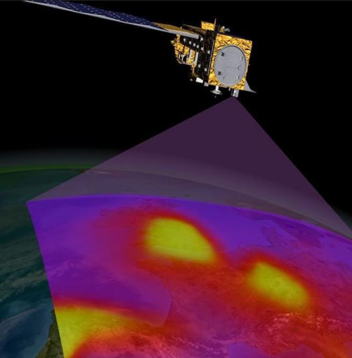
Data from the next-generation Instruments will help atmospheric scientists advance air quality measurements and standards.
20 MIN READ
Access NASA Earth observation data within three hours of a satellite observation through the Land, Atmosphere Near real-time Capability for Earth observation (LANCE).

NASA offers an array of carbon monoxide data to aid in determining its role in atmospheric processes, pollution, and climate.
Frequently Asked Questions
Earthdata Forum
Our online forum provides a space for users to browse thousands of FAQs about research needs, data, and data applications. You can also submit new questions for our experts to answer.
Submit Questions to Earthdata Forumand View Expert Responses