We are in the process of migrating all NASA Earth science data sites into Earthdata from now until end of 2026. Not all NASA Earth science data and resources will appear here until then. Thank you for your patience as we make this transition.
Read about the Web Unification Project
Natural Hazards News
Articles, resources, and announcements from Natural Hazards.
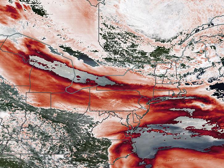
Satellite sensors captured views of smoky clouds extending thousands of miles and darkening skies across middle and eastern portions of North America.
Worldview Image of the Week
July 17, 2026

In early July 2026, several wildland fires sent smoke plumes across parts of Canada's Northwest Territories.
Worldview Image of the Week
July 10, 2026

Hot, dry, and windy conditions fueled the spread of wildfires across the region in late June and early July, when Suomi NPP captured this data.
Worldview Image of the Week
July 2, 2026

NASA's Fire Information for Resource Management System now provides swath outlines, showing the extent of Earth's surface within view of a sensor.
Blog
June 25, 2026

The VIIRS instrument aboard NOAA-20 captured these images of fires near the Yenisei River.
Worldview Image of the Week
June 17, 2026

The VIIRS instrument aboard NOAA-21 acquired data for a time-lapse animation of the fire in this national park.
Worldview Image of the Week
May 22, 2026

False-color Terra MODIS imagery and a snow cover index help distinguish clouds from snow on May 7, 2026.
Worldview Image of the Week
May 8, 2026

The MODIS instrument aboard the Terra platform captured this image on April 27, 2026.
Worldview Image of the Week
May 1, 2026
SHOWING 8 OF 539