We are in the process of migrating all NASA Earth science data sites into Earthdata from now until end of 2026. Not all NASA Earth science data and resources will appear here until then. Thank you for your patience as we make this transition.
Read about the Web Unification Project
Ocean Color Data Access and Tools
NASA has ocean color datasets that help researchers study the composition of ocean water and the processes that take place within it. Access a range of data and data tools such as AppEEARS, SeaDAS, and Giovanni to make the most of ocean color data.
Ocean Color Datasets
| Dataset | Version Sort ascending | Platforms | Instruments | Temporal Extent | Spatial Extent | Spatial Resolution | Data Format |
|---|---|---|---|---|---|---|---|
| Sentinel-3A OLCI Level-1B Earth-observation Reduced Resolution (ERR) Data, version 1 | 1 | Sentinel-3A | OLCI | 2016-04-05 to Present |
N: 90 S: -90 E: 180 W: -180 |
netCDF-4 | |
| Aqua MODIS Level-1 Level-1 Data, version 1 | 1 | Aqua | MODIS | 2002-07-04 to Present |
N: 90 S: -90 E: 180 W: -180 |
netCDF-4 | |
| PACE HARP2 Level-0 Detector 3 (D3) Data, V1 | 1 | PACE | HARP2 | 2024-02-08 to Present |
N: 90 S: -90 E: 180 W: -180 |
netCDF-4 | |
| COMS GOCI Level-1B Data, version 1 | 1 | COMS | GOCI | 2011-04-01 to 2021-03-31 |
N: 90 S: -90 E: 180 W: -180 |
application/gzip | |
| PACE HARP2 Level-0 Real-time Direct Transfer Mode Data, V1 | 1 | PACE | HARP2 | 2024-02-08 to Present |
N: 90 S: -90 E: 180 W: -180 |
netCDF-4 | |
| Sentinel-3B OLCI Earth-observation Reduced Resolution (ERR) Data, version 1 | 1 | Sentinel-3B | OLCI | 2018-04-25 |
N: 90 S: -90 E: 180 W: -180 |
netCDF-4 | |
| Nimbus-7 CZCS Level-0 Raw Science Data, version 1 | 1 | Nimbus-7 | CZCS | 1978-10-30 to 1986-06-22 |
N: 90 S: -90 E: 180 W: -180 |
binary | |
| PACE HARP2 Level-0 Science Data, V1 | 1 | PACE | HARP2 | 2024-02-08 to Present |
N: 90 S: -90 E: 180 W: -180 |
netCDF-4 | |
| PACE HARP2 Level-0 Detector 1 (D1) Data, V1 | 1 | PACE | HARP2 | 2024-02-08 to Present |
N: 90 S: -90 E: 180 W: -180 |
netCDF-4 | |
| PACE OCI Level-0 Science Data, version 1 | 1 | PACE | OCI | 2024-02-08 to Present |
N: 90 S: -90 E: 180 W: -180 |
netCDF-4 |
SHOWING 10 OF 93
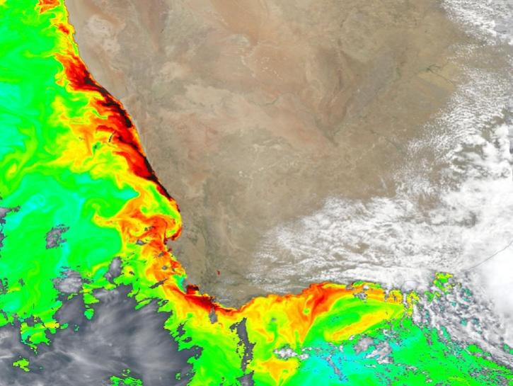
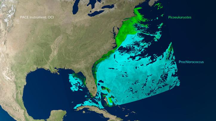
Featured Ocean Color Observation Method: PACE
NASA's Plankton, Aerosol, Cloud, ocean Ecosystem (PACE) platform measures the presence of phytoplankton, which are microscopic marine algae that can tint the ocean green and other colors. Phytoplankton function like plants in the ocean because they take up carbon dioxide and use it in photosynthesis to produce carbohydrates and oxygen. Phytoplankton help form the base of the ocean's food chain and are a key component of the carbon cycle. PACE and its optical spectrometer called the Ocean Color Instrument (OCI) can observe light reflected by phytoplankton and the ocean in unprecedented detail to provide essential data on its condition and health.
Join members of NASA's Ocean Biology Distributed Active Archive Center (OB.DAAC) to learn about data from the Plankton, Aerosol, Cloud, ocean Ecosystem (PACE) mission and how to discover, access, and use PACE data.
Simulated data help Plankton, Aerosol, Cloud, ocean Ecosystem (PACE) users prepare a day in the life of the new satellite.
6 MIN READ
A series of Jupyter notebook tutorials show how to retrieve and use data from NASA's Plankton, Aerosol, Cloud, ocean Ecosystem (PACE) mission.

MEaSUREs 2006 project focused on creating and distributing a variety of established and new Ocean Color products as candidates to become ESDRs.
Ocean Color Data Tools
| Tool Sort descending | Description | Services | |
|---|---|---|---|
| Ocean Color Level 3 and 4 Browser | The Ocean Color Level 3 and 4 Browser allows users to view, download, or order global composites at various spatial and temporal scales (level 3) or get results from analyses of lower-level data (level 4). | Analysis, Search and Discovery, Visualization | |
| SeaDAS | Sea, earth, atmosphere Data Analysis System (SeaDAS) is a comprehensive image analysis package for the processing, display, analysis, and quality control of ocean color data. | Analysis, Visualization, Processing |
SHOWING 2 OF 2
Frequently Asked Questions
Earthdata Forum
Our online forum provides a space for users to browse thousands of FAQs about research needs, data, and data applications. You can also submit new questions for our experts to answer.
Submit Questions to Earthdata Forumand View Expert Responses