We are in the process of migrating all NASA Earth science data sites into Earthdata from now until end of 2026. Not all NASA Earth science data and resources will appear here until then. Thank you for your patience as we make this transition.
Read about the Web Unification Project
Earthquakes Data Access and Tools
From discovery to visualization, data tools such as GeoGateway, NASA Worldview, and Earthdata Search guide users in making the most of earthquake data.
Earthquakes Datasets
SHOWING 10 OF 217
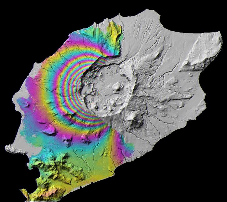
Featured Earthquakes Observation Method: Sentinel-1 C-SAR
The Synthetic Aperture Radar (SAR) aboard the ESA (European Space Agency's) Sentinel-1A/B satellites provides continuous all-weather, day-and-night land imagery. SAR images can be combined to produce interferograms, which are images showing changes in land height or position associated with earthquakes.
Join us Jan 25 at 2 p.m., ET [UTC -5], to learn how to use the Alaska Satellite Facility's OpenSARLab to work with synthetic aperture radar (SAR) data in the cloud.
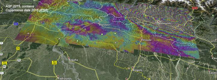
Ground deformation caused by the April 25 Nepal earthquake is clearly visible in this new interferogram processed from Sentinel-1A data by ASF DAAC scientists Franz Meyer and Wenyu Gong.

Explore and download data and imagery from EOSDIS for the the Nepalese region affected by the earthquake on April 25, 2015 and aftershocks.
2 MIN READ
Earthquakes Data Tools
| Tool Sort descending | Description | Services | |
|---|---|---|---|
| GUARDIAN | The GNSS-based Upper Atmospheric Realtime Disaster Information and Alert Network (GUARDIAN) is a near real-time (NRT) ionospheric monitoring tool for natural hazards warning. | Monitoring Natural Events | |
| Hazards Mapper | The Hazards Mapper enables users to rapidly get an idea of the population, land area, dams, and nuclear power plants that could be impacted by a wide range of natural events, including floods, earthquakes, fires, and volcanic eruptions. | Analysis, Search and Discovery, Visualization | |
| Panoply | Panoply is a cross-platform application that plots geo-referenced and other arrays from netCDF, HDF, GRIB, and other datasets. | Visualization, Customization, Reformatting, Subsetting, Comparison | |
| Vertex | Vertex is a graphical search interface for finding synthetic aperture radar (SAR) data. | Search and Discovery, Access, Downloading, Processing, Subsetting |
SHOWING 4 OF 4
Frequently Asked Questions
Earthdata Forum
Our online forum provides a space for users to browse thousands of FAQs about research needs, data, and data applications. You can also submit new questions for our experts to answer.
Submit Questions to Earthdata Forumand View Expert Responses