We are in the process of migrating all NASA Earth science data sites into Earthdata from now until end of 2026. Not all NASA Earth science data and resources will appear here until then. Thank you for your patience as we make this transition.
Read about the Web Unification Project
ECOSTRESS Resources
Access learning resources for the Ecosystem Spaceborne Thermal Radiometer Experiment on Space Station (ECOSTRESS) designed to help you optimize your Earth science research.
The ECOSTRESS Data Resources GitHub repository, maintained by NASA's Land Processes Distributed Active Archive Center (LP DAAC), provides guides, Python scripts, and Jupyter notebook tutorials to help users find, access, and work with ECOSTRESS data. This repository is publicly available and welcomes contributions from the community.
ECOSTRESS Learning Resources

This ARSET training provides lectures and case studies focused on the use of Earth observations for operational fire monitoring.
Training
May 11-27, 2021

Discover how a NASA DEVELOP team used NASA Earth science remote sensing data to observe the impacts urban growth has had on the city of Huntsville, Alabama.
Data in Action
Nov. 17, 2020

This ARSET training covers the use of remote sensing in determining and explaining urban heat islands, and ways to mitigate the effects.
Training
Nov. 10-24, 2020

See how the Tennessee Valley Energy DEVELOP team used Earth observations to predict river water temperatures for managing and protecting aquatic ecosystems.
Data in Action
July 1, 2020

This ARSET training addresses how to use remote sensing data for agriculture monitoring, specifically drought and crop monitoring.
Training
April 14 - May 5, 2020

In Spring 2019 DEVELOP researchers used VIIRS and other instrument data to create models that provide fine details on drought conditions in Iowa.
Data in Action
April 13, 2020
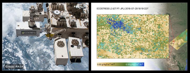
NASA's ECOSTRESS Mission studies how plants use water by measuring their temperature from space. Join us to learn more about ECOSTRESS mission measurements, data and tools!
Webinar
Feb. 18, 2020

During this webinar we will provide answers to commonly asked questions about NASA land processes data, services and tools, and show you how to navigate the new LP DAAC website to discover data resources.
Webinar
Jan. 15, 2020
SHOWING 8 OF 27

A summary of datasets, products, and resources released by NASA's Distributed Active Archive Centers (DAACs) in April 2024.
News
May 7, 2024
Members of NASA's Land Processes Distributed Active Archive Center (LP DAAC) highlighted their work in talks, workshops, and presentations at the American Geophysical Union Annual Meeting.
Blog
Jan. 30, 2024

A summary of datasets, products, and resources released by NASA’s Distributed Active Archive Centers (DAACs) in November 2023.
News
Dec. 5, 2023

Terrestrial Ecology Subsetting and Visualization Services (TESViS) supports ecological field research in easy-to-use formats.
Feature Article
June 30, 2023
SHOWING 4 OF 23
Frequently Asked Questions
Earthdata Forum
Our online forum provides a space for users to browse thousands of FAQs about research needs, data, and data applications. You can also submit new questions for our experts to answer.
Submit Questions to Earthdata Forumand View Expert Responses