We are in the process of migrating all NASA Earth science data sites into Earthdata from now until end of 2026. Not all NASA Earth science data and resources will appear here until then. Thank you for your patience as we make this transition.
Read about the Web Unification Project
Sentinel-2 MSI Resources
Earthdata resources for users working with NASA’s Multispectral Instrument include tutorials and other learning resources, news announcements such as instrument updates and data releases, user guides and related documents, and frequently asked questions.
Sentinel-2 MSI Learning Resources

This ARSET training explores how the R statistical coding language can be used to classify land cover and quantify changes in land cover over time.
Training
Feb. 24-26, 2026

This ARSET training introduces STREAM, a web tool for monitoring chlorophyll-a concentration, Secchi disk depth, and total suspended solids in inland lakes and coastal regions.
Training
Feb. 10-17, 2026

Using SNWG's OPERA DSWx product, USGS is able to monitor streamflow from space, augmenting hazardous in-person collection techniques.
Data in Action
July 8, 2025

This ARSET training provides an advanced understanding of radar remote sensing techniques for agriculture using machine learning methods.
Training
April 4-11, 2023
Learn how to search for, access, and process HLS data.
External Resource
GitHub Repository
Sept. 20, 2024
Find, download, and subset HLS data from a command line executable.
External Resource
GitHub Repository
April 16, 2025
Find and download HLS data.
External Resource
GitHub Repository
May 1, 2024

Tutorial demonstrating how to search for, access, and process HLS data in R.
External Resource
GitHub Repository
SHOWING 8 OF 60
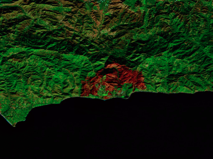
Image captured on Dec 18, 2024, by the MSI instrument aboard ESA's Sentinel-2B platform.
Worldview Image of the Week
Dec. 20, 2024

False-color reflectance image of burned areas near the Greek town of Marathon acquired on Aug 18, 2024.
Worldview Image of the Week
Aug. 22, 2024

A combination of Landsat and Sentinel-2 imagery, NASA near real-time data, and machine learning provides near real-time access to high-resolution water quality maps.
News
June 27, 2024

Global and US/Canada active Fire Maps enable users to visualize the location, extent, and impact of wildfires with minimal delay.
Feature Article
June 24, 2024
SHOWING 4 OF 64
Frequently Asked Questions
Earthdata Forum
Our online forum provides a space for users to browse thousands of FAQs about research needs, data, and data applications. You can also submit new questions for our experts to answer.
Submit Questions to Earthdata Forumand View Expert Responses