We are in the process of migrating all NASA Earth science data sites into Earthdata from now until end of 2026. Not all NASA Earth science data and resources will appear here until then. Thank you for your patience as we make this transition.
Read about the Web Unification Project
Suomi NPP Resources
Suomi NPP Learning Resources

This training builds capacity to apply Python codes and other online tools to work with datasets from NASA's Goddard Earth Observing System (GEOS).
Training
Feb. 22 - March 1, 2022

Esta capacitación de ARSET cubre el Kit de herramientas de observación de la Tierra para ciudades y asentamientos humanos sostenibles.
Training
Jan. 27 - Feb. 10, 2022
This ARSET training provides an overview of the Earth Observations Toolkit for Sustainable Cities and Human Settlements.
Training
Jan. 27 - Feb. 10, 2022

This ARSET training reviews pre-fire risk assessment and post-fire mapping using open-source tools like Google Earth Engine.
Training
Jan. 18-20, 2022

Learn about the NASA DEVELOP internship projects that used data distributed by the Land Processes Distributed Active Archive Center (LP DAAC) in spring 2021.
StoryMap
Dec. 3, 2021

This ARSET training provides participants with the skills to combine in situ measurements and optical remote sensing data to assess water quality.
Training
Nov. 30 - Dec. 7, 2021

Join us for an overview of NASA's LAADS DAAC, its Level-1 and atmospheric data products, and to explore different options to search, discover, and acquire the data.
Webinar
Oct. 25, 2021

This ARSET training provides an overview of NASA resources for monitoring climate change and its impacts.
Training
Sept. 29 - Oct. 6, 2021
SHOWING 8 OF 67
Suomi NPP News
View All News
Filters
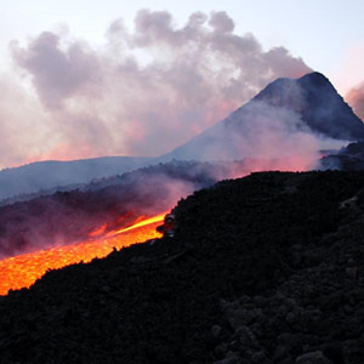
Tracking a volcanic plume reaches new heights, faster.
Feature Article
March 1, 2021
NASA's Level-1 and Atmosphere Archive and Distribution System Distributed Active Archive Center has joined the Earthdata Forum, NASA's interactive platform that gives data users the chance to communicate with and learn from experts.
News
March 1, 2021

Global climate change is leading to shifts in vital ecosystems. Dr. Malone uses Earth observation data to explore how a changing climate impacts ecosystem structure and function.
Data User Story
Feb. 25, 2021

Image captured on 31 January 2021, by the VIIRS instrument, aboard the joint NASA/NOAA Suomi NPP satellite.
Worldview Image of the Week
Feb. 8, 2021

Our atmosphere is a chemical soup that is constantly sampled by orbiting Earth observing satellites. Dr. Emily Fischer uses these data to better understand how pollutants move in the lower atmosphere.
Data User Story
Jan. 7, 2021


As rapid urbanization transforms India's landscape, doctors face a new set of challenges in protecting public health.
Feature Article
Dec. 28, 2020

Who uses NASA Earth science data? Dr. Michael Dietze, to improve ecological models through the integration of remotely-sensed data.
Data User Story
Dec. 22, 2020
SHOWING 8 OF 333
Frequently Asked Questions
Earthdata Forum
Our online forum provides a space for users to browse thousands of FAQs about research needs, data, and data applications. You can also submit new questions for our experts to answer.
Submit Questions to Earthdata Forumand View Expert Responses