We are in the process of migrating all NASA Earth science data sites into Earthdata from now until end of 2026. Not all NASA Earth science data and resources will appear here until then. Thank you for your patience as we make this transition.
Read about the Web Unification Project
Suomi NPP Resources
Suomi NPP Learning Resources

Esta capacitación de ARSET se centra en los datos de Black Marble y en cómo elegir el producto de iluminación nocturna adecuado.
Training
Dec. 3, 2020
This ARSET training focuses on building the skills needed to acquire and understand Black Marble data and choose the appropriate nighttime lights product.
Training
Dec. 3, 2020

This ARSET training covers the use of remote sensing in determining and explaining urban heat islands, and ways to mitigate the effects.
Training
Nov. 10-24, 2020

During this webinar we will introduce several of the NSIDC DAAC snow-focused NASA missions and data products, followed by a live demonstration teaching participants how to discover, access, and couple snow data across varying geospatial scales using Python.
Webinar
Nov. 4, 2020

This ARSET training covers how to access VIIRS data products, the differences between VIIRS and MODIS, and its air quality applications.
Training
Oct. 22, 2020

Esta formación ARSET abarca algunas de las dificultades asociadas a la teledetección de los ecosistemas costeros.
Training
Aug. 25 - Sept. 8, 2020
This ARSET training covers some of the difficulties associated with remote sensing of coastal ecosystems.
Training
Aug. 25 - Sept. 8, 2020

This ArcGIS Python Toolbox simplifies access to quality data by decoding complex quality information into usable thematic raster files.
Tutorial
Aug. 18, 2020
SHOWING 8 OF 67
Suomi NPP News
View All News
Filters

Who uses NASA Earth science data? Dr. Sergio Signorini, to study the impact of climate variability on phytoplankton and Earth’s oceans.
Data User Story
April 22, 2021

Who uses NASA Earth science data? Dr. Emily Berndt, to improve short-term forecasts of high-impact weather.
Data User Story
April 22, 2021

Ocean color data provide key information about ocean health. Dr. Barnes uses these data in his investigations into the health of optically shallow waters.
Data User Story
April 22, 2021

This ArcGIS StoryMap highlights Data User Profiles, Learning Resources and Worldview imagery layers in support of Earth Day 2021.
Feature Article
April 19, 2021
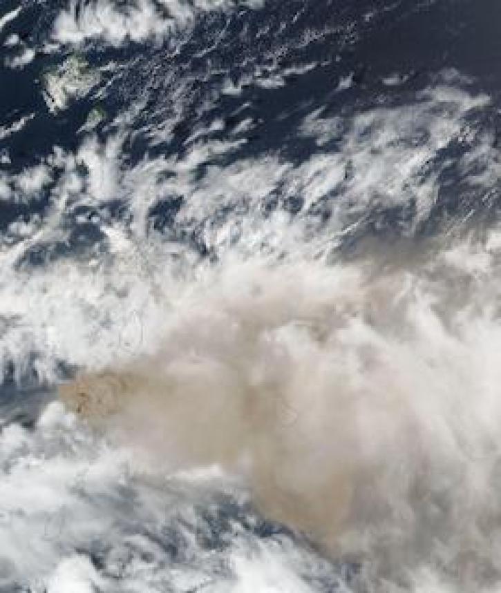
Image captured on 10 April 2021, by the VIIRS instrument, aboard the joint NASA/NOAA Suomi NPP satellite.
Worldview Image of the Week
April 19, 2021

NASA’s worldwide Fire Information for Resource Management System (FIRMS) provides vital near real-time tools for managing wildland fires.
Feature Article
April 15, 2021

A new Fire Information for Resource Management System (FIRMS) focused on the US and Canada provides expanded capabilities including additional map layers, ownership boundaries, and daily fire dangers.
News
April 13, 2021

Imagery of Earth at night provide unique opportunities for research. Dr. Miller uses these data in his studies of Earth’s nocturnal environment.
Data User Story
April 13, 2021
SHOWING 8 OF 333
Frequently Asked Questions
Earthdata Forum
Our online forum provides a space for users to browse thousands of FAQs about research needs, data, and data applications. You can also submit new questions for our experts to answer.
Submit Questions to Earthdata Forumand View Expert Responses