satellite imagery of Santa Barbara
SHIFT flight path

SHIFT

Surface Biology and Geology (SBG) High Frequency Time Series

The Surface Biology and Geology (SBG) High Frequency Time Series (SHIFT) was an airborne and field campaign that occurred over several weeks in 2022 in support of NASA's SBG mission. Its study area included a 640-square-mile (1,656-square-kilometer) region in Santa Barbara County and the coastal Pacific waters. 

The primary goal of the SHIFT campaign was to collect a repeated dense time series of airborne visible to shortwave infrared (VSWIR) airborne imaging spectroscopy data with coincident field measurements in both inland terrestrial and coastal aquatic areas, supported in part by a broad team of research collaborators at academic institutions. 

The SHIFT campaign leveraged NASA's Airborne Visible-Infrared Imaging Spectrometer-Next Generation (AVIRIS-NG) facility instrument to collect approximately weekly VSWIR imagery across the study area.

Accomplishments of the SHIFT campaign include:

  • Enable the NASA SBG team to conduct traceability analyses related to the science value of VSWIR revisit without relying on multispectral proxies.
  • Enable testing algorithms for consistent performance over seasonal time scales and end-to-end workflows including community distribution.
  • Provide early adoption test cases to SHIFT application users and incubate relationships with basic and applied science partners at the University of California Santa Barbara Sedgwick Reserve and The Nature Conservancy's Jack and Laura Dangermond Preserve.
Study DatesFebruary - May, 2022, with a follow up activity for one week in September
Season of StudyBoreal fall, boreal spring, boreal winter
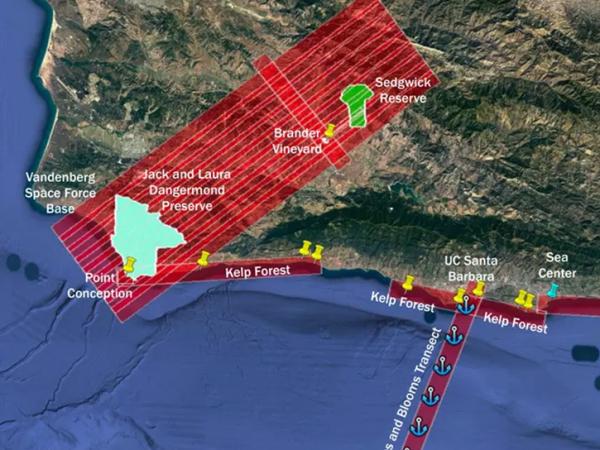
RegionSanta Barbara County, California, Pacific Ocean
Spatial Bounds

N: 35°N

S: 33°N

W: 121°W

E: 117°W

Focus Areas

Carbon Cycle and Ecosystems

Climate Variability and Change

Geophysical Concepts

Ecosystems/Biogeochemical Interactions

Biodiversity

Land Characteristics

Scientific Topics

Spectral Imagery

Vegetation

Land Characteristics

Land Surface

Surface Radiative Properties

Reflectance

Radiance

Land Surface Temperature

Emissivity

PlatformInstrument(s)
B-200
Airborne Visible InfraRed Imaging Spectrometer - Next Generation (AVIRIS-NG)
Twin Otter
Hyperspectral Thermal Emission Spectrometer (HyTES)
Field SiteGeneric-Radiometers
Field Survey

Spectrometers

Digital Camera