Monitor Floods Globally and in Near Real-Time With VIIRS

The new VIIRS near real-time product is already in use, and users are encouraged to explore this replacement option for MODIS-based flood products.

In April, NASA released a new near real-time (NRT) flood product generated from the Visible Infrared Imaging Radiometer Suite (VIIRS) instruments aboard the NOAA-20 and NOAA-21 satellites. NASA has been generating a readily accessible global NRT flood product from the Moderate Resolution Imaging Spectroradiometer (MODIS) instruments since 2012, and the addition of this new product from VIIRS will support continuity as the MODIS instruments reach end of life (read more about the MODIS to VIIRS transition that will occur in the next few years). In the meantime, both the MODIS-based and VIIRS-based flood products will be generated in tandem, providing users an opportunity to have a second "look" at floods and enabling them to compare the MODIS and VIIRS products.

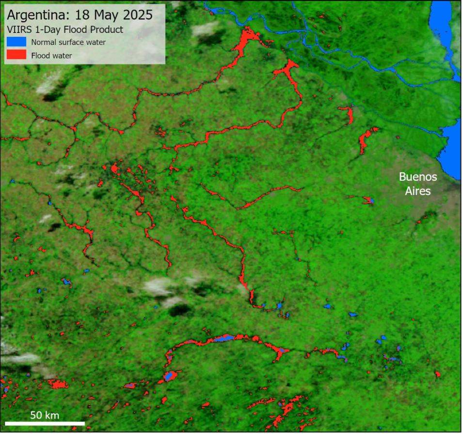
As with the MODIS product, the VIIRS product is most useful in relatively cloud free areas and/or where there are longer lasting floods. As MODIS and VIIRS are optical sensors, cloud cover will block the view of the surface, and thus limit the detection of water and flood. Flash floods can also be difficult to capture because observations are only available in a short daily window (early afternoon for VIIRS). Despite these limitations, the VIIRS product has already highlighted recent flooding, including in the U.S. Mississippi River valley and in Argentina, as the below examples demonstrate.
Image
Image Caption

VIIRS 1-day flood product for May 18, 2025, showing flooding in Buenos Aires province, Argentina. Credit: NASA

Image
Image Caption

VIIRS 1-day flood product for April 8, 2025, showing extensive flooding in the Mississippi River valley, in eastern Missouri and Arkansas, western Tennessee, and southwestern Kentucky. Credit: NASA

The team is planning a number of updates to the product in the future. These include:

  • Adding a “recurring flood” class to the product, based on a recent reprocessing of the product back to 2003, to distinguish regular or expected flooding from unusual flooding. 
  • Potentially updating the water detection algorithm with a machine-learning approach, which shows promise to minimize issues with cloud and terrain shadow. 
  • Potentially adding Sentinel-3 inputs to provide a morning observation to the product. 
  • Exploring a possible 5-day product. 

The team welcomes user input on these potential additions or other improvements that users would find helpful. The team is also interested to hear how the product is being used to support different applications or areas of research. Please submit your feedback via email.

The NRT Global Flood Product page has more information about MODIS and VIIRS products and how to access them.

Details

Last Updated

June 4, 2025

Published

June 2, 2025