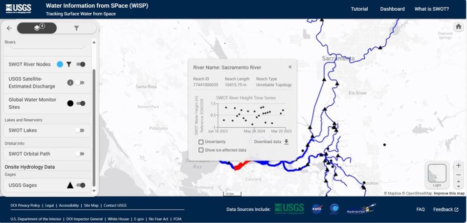
Water Information from SPace (WISP), a new online application created by the United States Geological Survey (USGS) and supported by NASA’s Physical Oceanography Distributed Active Archive Center (PO.DAAC), brings two critical sources of information about America’s freshwater resources together into one interactive, user-friendly dashboard.
USGS Releases WISP Dashboard
“WISP provides a single website for users to interact with and download data from,” said PO.DAAC Cloud Adoption Engineer Nikki Tebaldi. “We contribute hydrology observations from NASA’s Surface Water Ocean Topography (SWOT) satellite and [the USGS] has their stream flow and water level data in there, which is used quite widely by the hydrology community. So, bringing all these data together into a single website is very beneficial.”
Changes in Earth’s climate may profoundly alter the movement of freshwater resources from lakes to rivers to reservoirs, resulting in significant societal impact. Without an adequate inventory of the volume of water in and storage capacity of Earth's lakes, it is difficult to assess the effects of environmental change on agriculture, industry, and other sectors. Similarly, adequate information on river flow and discharge is imperative for managing water resources and planning for natural hazards like floods and droughts, particularly in the river basins that sustain large human populations in the U.S. and around the globe.
SWOT data provides scientists with key measurements of all these hydrological attributes, thereby supporting scientific research into the impacts of land on the water cycle, the dynamics of floodplains and wetlands (which influences flood control), and the effort to create a global inventory of water resources, including transboundary rivers, lake and reservoir storage, and river dynamics.
WISP is designed to familiarize users with a variety of SWOT lake and river data by collocating them with measurements from the USGS streamgages placed in waterways across the U.S. The SWOT observations available in WISP include:
| SWOT River Data | River centerlines along reaches that contain data from the SWOT satellite |
| SWOT River Nodes | Points along a river centerline spaced every ~200 meters that contain data from the SWOT satellite |
| USGS Satellite-Estimated Discharge | USGS sites in Alaska that contain remotely sensed discharge estimates from SWOT and other satellites |
| Global Water Monitor Sites | River water levels from satellite altimeters aboard the European Space Agency’s Sentinel-6 satellite, and the European Organization for the Exploitation of Meteorological Satellites series of Jason satellites |
| SWOT Lakes | Lake polygons expected to be routinely monitored by the SWOT satellite |
| SWOT Orbital Path | Swath overpass footprints from the SWOT satellite |
| USGS Gages | Streamgages near SWOT-observable rivers |
SWOT time series data is made available to WISP via Hydrocron, an application programming interface (API) that allows users to specify the identifier of a single river reach or node (i.e., a section or point) along a river of interest and then receive all SWOT observations within a specified date range. Hydrocron ingests data from the SWOT Level 2 River Single-Pass Vector Product, the SWOT Level 2 Lake Single-Pass Vector Product, and the SWOT River Database.
Because APIs can be incorporated into other digital products, including dashboards offering data access and visualization, Tebaldi and Dahl believe incorporating Hydrocron into WISP will bring SWOT data to a wider audience.
“Providing an API in front of our data really facilitates users' ability to take the SWOT observations and collocate them. Users can see time series within the dashboard and download the data from there, so it's like an entry point into how the data can be used,” Tebaldi said. “It's a great ways for people to dive into the SWOT data, which can be a bit overwhelming because there are so many datasets.”
WISP is also a great way for decision makers to incorporate NASA and USGS data into their operations.
“The USGS team was excited to bring this SWOT and hydrology gage data together,” said PO.DAAC Manager Luke Dahl. “By collaborating with them on this, we're making this data available to decision makers in the application community. We know there are communities around the world that are interested in this data, so we're trying to make sure they're taking advantage of this approach.”
To that end, Dahl is hopeful that other organizations and stakeholders will follow the USGS’s lead.
“We want to enable the use of [SWOT] data in ways that can be integrated in other applications,” said Dahl. “So, by putting an API in front of this data, we are enabling not just WISP, but others around the world to build on that and build their own applications to take advantage it.”
Resources
The PO.DAAC Cookbook, which provides tutorials for working with PO.DAAC data in the cloud, has a chapter devoted to SWOT data.
Accessing Data for the World's Water with SWOT (Webinar)
Hydrocron: A New Tool for SWOT Time Series Analysis | NASA Earthdata (Article)
