Earth Science Data Roundup: May 2025

A summary of datasets, products, and resources released by NASA’s Distributed Active Archive Centers (DAACs) in April 2025.

Atmospheric Science Data Center (ASDC)

CERES Edition 1C NOAA-20 SSF1deg Product Suite Released

NASA’s ASDC released Edition 1C of the NOAA-20 Level 3, Single Scanner Footprint (SSF), 1-degree gridded data product suite from the Clouds and the Earth's Radiant Energy System (CERES) Science Team's Radiation Budget Science Project.

The products in this suite contain gridded, regionally averaged data of CERES reflected shortwave (SW), emitted longwave (LW), and longwave-channel (LW-chan) top-of-atmosphere (TOA) fluxes. They also include cloud and aerosol properties derived from the Visible Infrared Imaging Radiometer Suite (VIIRS) instrument, co-located on the NOAA-20 satellite, as well as meteorological information from the Modern-Era Retrospective analysis for Research and Applications, Version 2 (MERRA-2) data product.

The data are available at three temporal scales:

These products are available from May 2018 to November 2024, with forward-processing continuing as more data become available.

Access CERES Edition 1C NOAA-20 SSF1deg data and more information.

Image
Image Caption

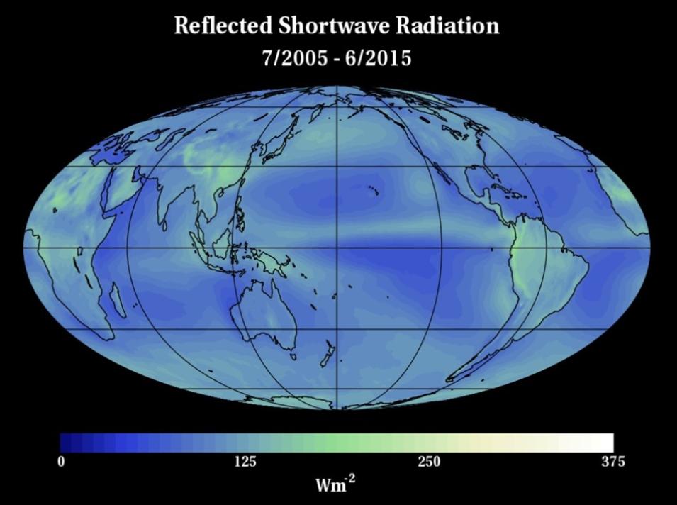
This visualization shows top-of-atmosphere reflected shortwave radiation data (in watts per meter squared) from the CERES instrument. Lighter areas indicate the presence of increased radiation. Credit: NASA

CERES SSF NOAA20-FM6-VIIRS_Edition1C Product Available

The NOAA-20 Single Scanner Footprint (SSF) Clouds and the Earth's Radiant Energy System (CERES) Level 2 observed top-of-atmosphere (TOA) broadband radiances and fluxes Edition1C data product is now available from ASDC. 

The SSF granule contains instantaneous CERES Flight Model 6 (FM6) Earth-viewing footprints filtered radiances for the total, shortwave (SW), and longwave (LW) broadband channels, and the unfiltered SW, LW (determined from the difference between total and SW), and LW-channel radiances. The SW, LW, and LW-channel radiances at spacecraft altitude are converted to TOA fluxes based on the VIIRS-defined scene. The TOA fluxes are used to estimate surface fluxes. The VIIRS radiances are used with CERES-specific cloud masks and retrievals to provide pixel-level cloud properties, and this data is averaged over the larger CERES footprint for up to two distinct non-overlapping cloud layers. Each cloud layer has properties such as amount, height, temperature, pressure, optical depth, emissivity, phase, water path, and water particle size. Each footprint contains the VIIRS aerosol optical depth and imager radiance values. Only footprints with adequate imager coverage are included on the SSF product, much less than the full set of footprints that can be found on the CERES ERBE-like Instantaneous TOA Estimates (ES8) product. 

The data product’s temporal coverage begins May 1, 2018, and is in progress. It is distributed in hourly netCDF 4 files, each containing approximately six-tenths of an orbit.

Access CERES SSF NOAA20-FM6-VIIRS_Edition1C data and more information.

SAGE III/ISS Version 6.0 Data Products Released

ASDC released a suite of SAGE III/ISS Version 6.0 Data Products. Version 6.0 includes Level 1B, Solar Level 2 (L2), and Lunar L2 data products, as well as algorithmic improvements, updated ancillary inputs, and the convergence of data products previously available only in separate files/outlets. Traditional SAGE products now are packaged with the newly developed derived products aerosol/cloud flag and particle size distribution parameters.

The products included in this release are:

Observations cover June 2017 through December 2024. Until further notice, all forward processing of SAGE III/ISS will be under version 6.0, which is the suggested version, but prior versions are available on request. Users are advised to pay special attention to the release notes and the user’s guides for these products, as the contents have changed from past versions for all three types of scientific data formats containing SAGE III/ISS data.

SAGE III is installed on the International Space Station (SAGE III/ISS) mission and takes measurements across the globe using a technique called occultation. Every time the sun, or moon, rises and sets, SAGE uses the light that passes through the atmosphere to measure gases and particles in that region of the atmosphere. From the ISS, this happens over 30 times per day. The data provided by SAGE III-ISS includes key components of atmospheric composition and their long-term variability, focusing on the study of aerosols, chlorine dioxide, clouds, nitrogen dioxide, nitrogen trioxide, pressure and temperature, and water vapor.

Access SAGE III/ISS Version 6.0 data and more information.

Image
Image Caption

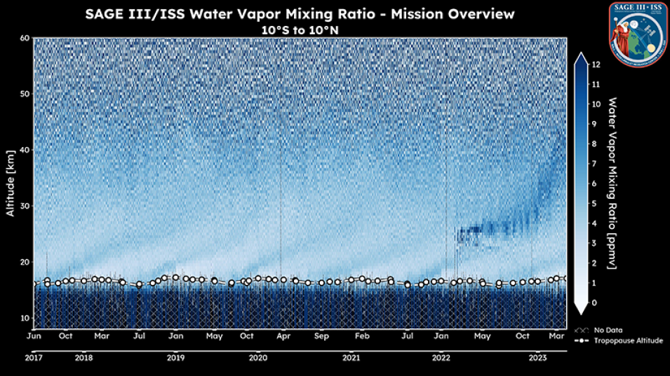
This graphic from the SAGE III Experiment shows measurements of the water vapor mixing ratio, or the ratio of the mass of water vapor to the mass of dry air (in parts per mission by volume [ppmv]), at various times of year from 2017 to 2023. Credit: NASA

MOPITT Officially Turned Off

After 25 years of pioneering data collection, the Measurements Of Pollution In The Troposphere (MOPITT) instrument aboard NASA's Terra satellite was turned off because Terra had insufficient power. February 1, 2025, was its last day of active MOPITT observations. This climate data record has been a crucial contribution to our understanding of atmospheric chemistry and changing emission sources. MOPITT data has been used in hundreds of scientific papers and many data assimilation projects.

Looking forward, ASDC plans to make a definitive final version of the 25-year MOPITT data record, including a unique product for the carbon monoxide column in the lower troposphere.

Read more about MOPITT's legacy.

Image
Image Caption

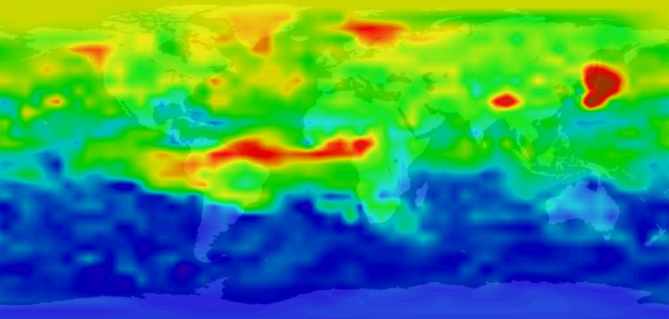
This visualization of MOPITT data shows global carbon monoxide (CO) levels measured in parts per billion on March 23, 2000. Brighter colors (e.g., orange, red, and yellow) indicate higher concentrations of CO, whereas darker colors (e.g., blues and green) indicate lower concentrations. Credit: NASA GSFC, SVS

Student Airborne Research Program Data Now Available

Data from the Student Airborne Research Program (SARP) is available from NASA’s ASDC. SARP is an eight-week summer internship program for rising senior undergraduate students to acquire hands-on research experience in all aspects of a scientific field campaign. SARP has been active since 2009 and has been using one of the major NASA Airborne Science Program flying science laboratories to study Earth system processes, calibration/validation, and prototyping of instruments for possible satellite missions. Research areas for SARP include atmospheric chemistry, forest ecology, air quality, and ocean biology.

Learn more about SARP.

Global Hydrometeorology Resource Center Distributed Active Archive Center (GHRC DAAC)

GPM Ground Validation Dual-frequency Dual-polarized Doppler Radar (D3R) UCONN Dataset Released

NASA's GHRC DAAC released the Global Precipitation Measurement (GPM) Ground Validation Dual-frequency Dual-polarized Doppler Radar (D3R) University of Connecticut (UCONN) dataset, which includes reflectivity, differential reflectivity, co-polar correlation coefficient, differential propagation phase, radial velocity, and spectrum width data collected by the D3R. 

These data were collected during the GPM Ground Validation Field Campaign at UCONN, which provided a set of wintry precipitation observations from multiple traditional and novel precipitation-measurement instruments that can be used for validating ground-based and satellite remote-sensing observations. The D3R dataset files are available from January 1, 2023, through April 10, 2023, in netCDF-4 format.

Access the GPM D3R UCONN data and more information.

Image
Image Caption

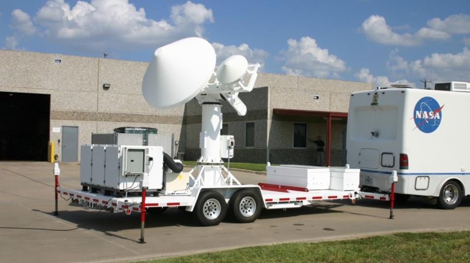
The Dual-polarized Doppler Radar (D3R) is a transportable radar with the same frequencies as the GPM Core satellite Dual-frequency Precipitation Radar (DPR). It is used for assessing dual-frequency path integrated attenuation algorithms and quantifying rainfall rate, particle size distributions, water contents, and precipitation type. It is especially useful for studying falling snow. Credit: NASA

GPM Ground Validation All-in-One Sonic Weather Sensor (AIO2) UCONN Dataset Available

The GPM Ground Validation MetOne All-in-One 2 (AIO2) Weather Sensor University of Connecticut (UCONN) dataset is now available from the GHRC DAAC. This dataset provides measurements of wind speed, wind direction, ambient air temperature, relative humidity, and barometric pressure collected during the GPM Ground Validation Field Campaign at the University of Connecticut, which provided a set of wintry precipitation observations from multiple traditional and novel precipitation measurement instruments that can be used for validating ground-based and satellite remote sensing observations. 

The AIO2 dataset files are available from December 7, 2021, through May 21, 2024, in CSV format, and cover the entire deployment season, which is generally 4 to 5 months.

Access AIO2 data and more information.

Goddard Earth Sciences Data and Information Services Center (GES DISC)

Level 3 Frequency of Dust Storm Collections Version 1 Dataset Released

NASA's GES DISC released six collections of Level 3 Moderate Resolution Imaging Spectroradiometer (MODIS) Monthly Frequency of Dust Storms (FDS) Version 1. These products provide Level 3 FDS over land from 175°W to 175°E and 80°S to 80°N at a spatial resolution of 0.1° x 0.1°. Of the six collections, three are derived from the MODIS instrument aboard NASA’s Terra satellite, and the remaining three are derived from the MODIS instrument aboard NASA’s Aqua satellite. 

The FDS is calculated as the number of days per month when the daily dust optical depth is greater than one of eight different threshold values, and for two levels of quality control associated with the retrieval of MODIS aerosol products. 

The three Level 3 FDS collections Version 1 based on MODIS Terra data are:

The three Level 3  FDS collections Version 1 based on MODIS Aqua data are:

These products are useful for detecting even the weakest dust sources and understanding the evolution of their activity over the last 20 years. In addition, the data has practical applications in evaluating mineral dust simulation in forecasting or climate models.

Access Level 3 FDS collections Version 1 data and more information.

Image
Image Caption

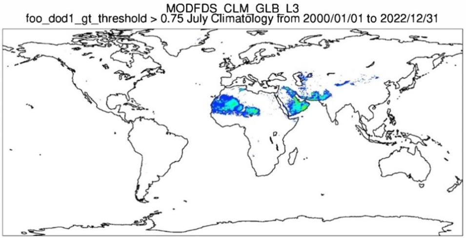
This graphic of MODIS Monthly Frequency of Dust Storms (FDS) Version 1 data shows climatological monthly frequency of dust storms over land when the intensity of dust optical depth is less than the 0.75 threshold. Credit: GES DISC

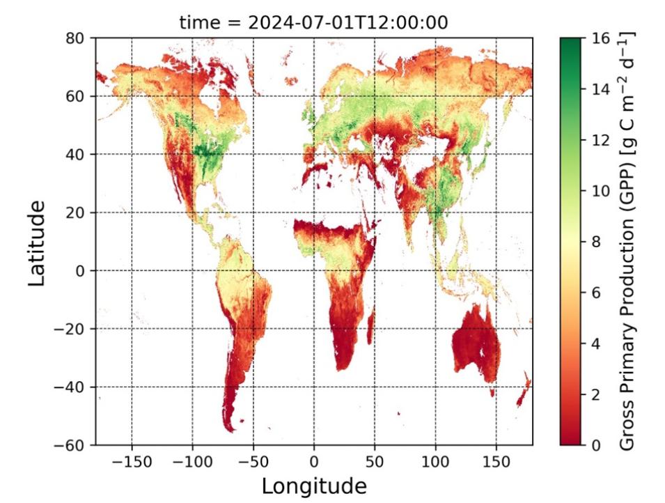
FluxSat Gross Primary Production (GPP) version 2.2 Dataset Now Available

The FluxSat Gross Primary Product (GPP) version 2.2 data products are now available from GES DISC. These data collections provide global, gridded, daily estimates of GPP and uncertainties at 0.05° x 0.05° and 0.5° x 0.625° resolutions from March 2000 to the present. GPP is derived from data captured by the MODIS instruments aboard NASA's Terra and Aqua satellites. The data are then used as inputs for neural network models to upscale GPP estimates from global in-situ network sites. 

Both data collections are organized into monthly files containing daily gridded data:

  • The FluxSatMGPP_L3_Daily_p05deg data product is calculated at the resolution of MODIS Global MODIS and FLUXNET-derived Daily Gross Primary Production, version 2 datasets on the Climate Modeling Grid (CMG): 0.05° latitude by 0.05° longitude
  • The FluxSatMGPP_L3_Daily_p5deg is averaged at the resolution of the Global Modeling and Assimilation Office (GMAO) Modern-Era Retrospecive analysis for Research and Applications 2 (MERRA-2) product: 0.5° latitude by 0.625° longitude

Access GPP version 2.2 data and more information.

Image
Image Caption

This graphic shows FluxSat Gross Primary Product (GPP) version 2.2 data of Gross Primary Productivity across the world in July 2024. GPP is derived from data captured by the MODIS instruments aboard NASA's Terra and Aqua satellites. The data are then used as inputs for neural network models to upscale GPP estimates from global in-situ network sites. Credit: GES DISC

Land Processes Distributed Active Archive Center (LP DAAC)

GEDI Version 2 Data for April through November 2024 Released

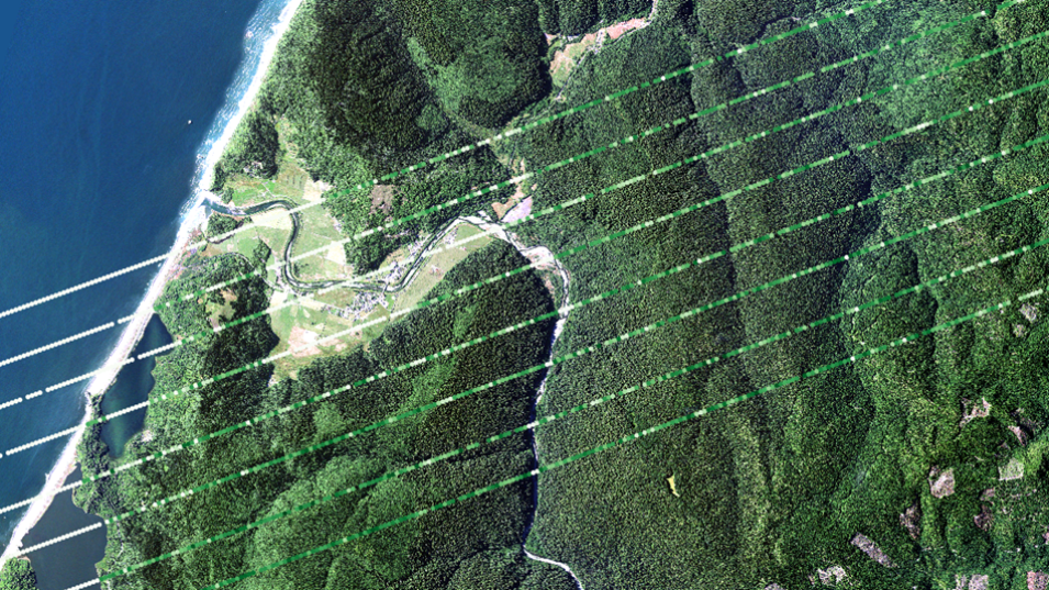
NASA's LP DAAC released the Global Ecosystem Dynamics Investigation (GEDI) Version 2 Level 1B Geolocated Waveform, Level 2A Elevation and Height Metrics, and Level 2B Canopy Cover and Vertical Profile Metrics datasets for April 27, 2024, through November 28, 2024. These datasets are the first release of new data since the GEDI instrument was re-installed on the International Space Station in the spring of 2024. Operations have resumed and users can expect deliveries again on a regular cadence. Users should note that no acquisitions occurred while the GEDI instrument was in storage resulting in a data gap from March 17, 2023, to April 27, 2024.

Access GEDI Version 2 Data datasets and more information.

Image
Image Caption

This graphic shows Version 2 GEDI Level 2B Plant Area Index (PAI) data over Redwoods National Park in California from June 19, 2019, with USDA National agriculture Imagery Program data from 2020 as a basemap. Credit: LP DAAC

AppEEARS Version 3.79 Available

Version 3.79 of the Application for Extracting and Exploring Analysis Ready Samples (AppEEARS) is now available. This release adds the Land Surface Phenology Yearly L3 Global 500 m SIN Grid Version 2 (VNP22Q2.002) product from the Visible Infrared Imaging Radiometer Suite (VIIRS) instrument aboard the NASA-NOAA Suomi National Polar-orbiting Partnership satellite (Suomi NPP) to AppEEARS.

AppEEARS enables users to perform data access and transformation processes by enabling users to download only the data they need. AppEEARS provides access to a wide range of geospatial data from multiple federal archives.

A complete listing of data products available in AppEEARS can be found on the available products List.

Learn more about this AppEEARS release.

LP DAAC Ends Distribution of Version 1 VIIRS and ECOSTRESS Products

VIIRS Version 1 SR, VI, LAI/FPAR, LST, and Active Fires Data Products

On April 8, 2025, LP DAAC ceased distribution of the VIIRS Version 1 Surface Reflectance (SR), Leaf Area Index (LAI), Fraction of Photosynthetically Active Radiation (FPAR), Land Surface Temperature (LST), and Active Fires Products. These products are no longer available for search and download from NASA’s Earthdata Search, Data Pool, or AppEEARS.

The user guides and algorithm theoretical basis documents for VIIRS Version 1 data products will be retained and available via the Digital Object Identifier (DOI) landing pages on the LP DAAC website. The DOI landing pages will remain available as a permanent URL for historical information and citations.

Users are encouraged to transition to the VIIRS version 2 data products, which includes data from both Suomi NPP and NOAA-20 satellites. The complete list of VIIRS Version 2 data products is cataloged in the VIIRS Products Table.

Learn more about the removal of these VIIRS data products.

ECOSTRESS Version 1 Attitude (ECO1BATT) Product

In addition, the LP DAAC announced that the Ecosystem Spaceborne Thermal Radiometer Experiment on Space Station (ECOSTRESS) Attitude Daily Level 1B Global 70-meter Version 1 (ECO1BATT) data product will no longer be available through the LP DAAC Data Pool or Earthdata Search as of April 21, 2025. ECO1BATT users are encouraged to transition to the ECOSTRESS Swath Attitude and Ephemeris Instantaneous Level 1B Global Version 2 (ECO_L1B_ATT) data product. Users working with ECOSTRESS Version 1 data are encouraged to migrate their workflows to the version 2 data products as historical processing is being completed.

Learn more about the removal of these VIIRS and ECOSTRESS data products.

2024 OPERA Level 3 Disturbance Annual HLS Version 1 Data Unavailable

LP DAAC announced that, due to a disturbance alert from 2023 discovered in the Observational Products for End-Users from Remote Sensing Analysis (OPERA) Land Surface Disturbance Annual data from the Harmonized Landsat Sentinel-2 (HLS_ product Version 1 (OPERA_L3_DIST-ANN-HLS_V1) for the year 2024, all 2024 data have been removed from the LP DAAC archive. 

Users who accessed OPERA_L3_DIST-ANN-HLS_V1 data for 2024 through NASA’s Earthdata Search are encouraged to use the corrected data products for scientific analysis once they become available. 

Learn more about this product from OPERA.

Level 1 and Atmosphere Archive and Distribution System Distributed Active Archive Center (LAADS DAAC)

Version 2.1 NOAA-21 VIIRS Level-1 Data Product Suite Released

NASA’s LAADS DAAC released two Version 2.1 JPSS2 (now known as NOAA-21) Visible Infrared Imaging Radiometer Suite (VIIRS) Level-1 data collections that include calibrated radiances and geolocation information. Each collection relates to image-resolution, moderate-resolution, and day-night band resolution. The six data products included in this release are:   

Data ProductDescription
VIIRS/JPSS2 Moderate Resolution Terrain-Corrected Geolocation 6-Min Level 1 Swath 750 meter (VJ203MOD)This product includes geodetic latitude, longitude, surface height above the geoid, solar zenith and azimuth angles, sensor zenith and azimuth angles, land/water mask, and quality flag for every pixel location. VJ203MOD provides a fundamental input to derive a number of VIIRS M-band higher-level products. The data record starts from February 10, 2023.
VIIRS/JPSS2 Imagery Resolution Terrain-Corrected Geolocation 6-Min Level 1 Swath 375 meter (VJ203IMG)This product includes geodetic latitude, longitude, surface height above the geoid, solar zenith and azimuth angles, sensor zenith and azimuth angles, land/water mask, and quality flag for every pixel location. Its data record starts from February 10, 2023.
VIIRS/JPSS2 Day/Night Band Moderate Resolution Terrain-Corrected Geolocation 6-Min Level 1 Swath 750 meter (VJ203DNB)This product includes geodetic latitude, longitude, surface height above the geoid, solar zenith and azimuth angles, lunar zenith and azimuth angles, sensor zenith and azimuth angles, land/water mask, moon illumination fraction and phase angle, and quality flag for every pixel location. The data product described in this landing page is a v2.1 collection and its data record starts from February 10, 2023.
VIIRS/JPSS2 Moderate Resolution 6-Min Level 1B Swath 750 meter (VJ202MOD)Derived from the NASA VIIRS Level 1A raw radiances, this product includes calibrated and geolocated radiance and reflectance data, quality flags, and granule- and collection-level metadata. The image dimensions of the 750-m swath product measure 3232 lines by 3200 pixels and its data record starts from February 10, 2023.
VIIRS/JPSS2 Imagery Resolution 6-Min Level 1B Swath 375 meter (VJ202IMG)Derived from the NASA VIIRS Level 1A raw radiances, this product includes calibrated and geolocated radiance and reflectance data, quality flags, and granule- and collection-level metadata. The image dimensions of the 375-m swath product measure 6464 lines by 6400 pixels and its data record starts from February 10, 2023.
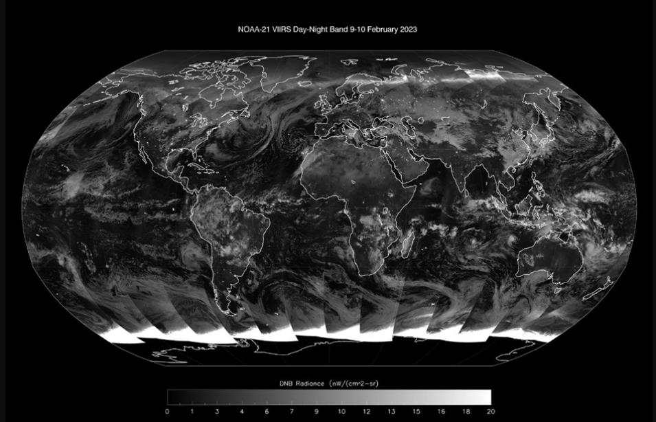
VIIRS/JPSS2 Day/Night Band (DNB) Moderate Resolution 6-Min Level 1B Swath 750 meter (VJ202DNB)The DNB facilitates measuring night lights, reflected solar/lunar lights with a large dynamic range between a low of a quarter moon illumination to the brightest daylight. The image dimensions of the 750-mmeter DNB product measure 3232 lines by 4064 pixels and its data record starts from February 10, 2023.

Learn more about the version 2.1 NOAA-21 VIIRS Level-1 data product suite.
Image
Image Caption

This global composite image shows Day/Night Band data from the VIIRS instrument aboard NOAA-21 for February 9-10, 2023. Credit: NOAA

National Snow and Ice Data Center Distributed Active Archive Center (NSIDC DAAC)

ATLAS/ICESat-2 L3A Along Track Coastal and Nearshore Bathymetry Dataset Released

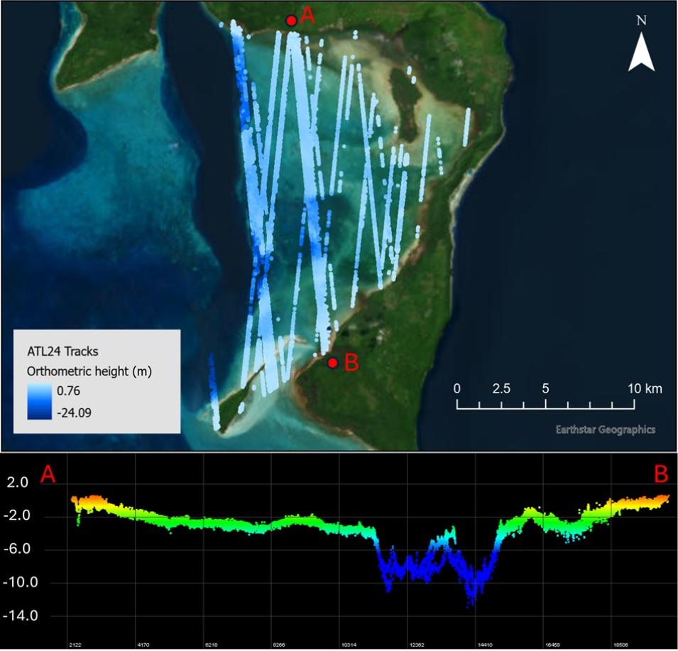
NASA's NSIDC DAAC released the Advanced Topographic Laser Altimeter System (ATLAS)/Ice, Cloud, and Land Elevation Satellite-2 (ICESat-2) Level 3A Along Track Coastal and Nearshore Bathymetry, Version 1 dataset. This data product contains global along-track coastal and nearshore bathymetry consisting of refraction-corrected seafloor and sea surface heights (orthometric and ellipsoidal heights and instantaneous depths), as well as associated uncertainties. 

The ATL24 data product is derived from the ATLAS/ICESat-2 Level 2A Global Geolocated Photon Dataset (ATL03) and processed with a bathymetric search mask designed to reduce computation time by removing data on land or in areas that are too deep or turbid for ICESat-2 measurements. Then these data are subjected to an ensemble model approach for signal classification to ensure operability across a full extent of seafloor types, morphologies, depth ranges, water types, and cover types that exist throughout coastal and nearshore areas. Finally, the data undergo a series of checks, corrections, and calculations (i.e., blunder detection, refraction correction, and uncertainty calculations) before the product is complete.

Access ATL24 data and more information about the dataset.

Image
Image Caption

This true-color image of Kiriwina Island in in Papua New Guinea shows the 55 tracks of ATL24 bathymetry (top) and an elevation profile depicting the lagoon bathymetry from Point A to Point B (bottom). Credit: Chris Parrish/Oregon state University

AMSR-E/AMSR2 Unified Level 3 Daily Brightness Temperatures and Sea Ice Polar Gridded Datasets Updated

NSIDC DAAC updated the following Advanced Microwave Scanning Radiometer for EOS (AMSR-E)/ Advanced Microwave Scanning Radiometer 2 (AMSR2) datasets:

These datasets contain average daily horizontally and vertically polarized brightness temperatures, sea ice concentrations, and snow depths over sea ice on north and south polar stereographic grids. The data are derived from observations acquired by the AMSR-E and AMSR2 instruments that have been spatially resampled by the Japan Aerospace Exploration Agency (JAXA) to unify the AMSR-E and AMSR2 missions.

This update includes the addition of the AMSR-E derived data, with each product now covering the temporal range of June 2002 to the present (with a gap in data from October 2011 to July 2012, between the end of the AMSR-E mission and the beginning of AMSR2). Additionally, the pre-existing AMSR2 data for each product has been reprocessed to address some minor issues with the file metadata. This change may impact users of the 12.5 km product that use certain tools (e.g., Panoply) to plot variables located in the root of the file. 

Access the updated AMSR-E/AMSR2 data and more information about these datasets

GLIMS Glacier Database, Version 1 Dataset Updated

The NSIDC DAAC updated the Global Land Ice Measurements from Space (GLIMS) Glacier Database, Version 1 dataset. This update includes new glacier outlines for several regions, including Arctic Russia, Alaska, Glacier National Park, Indonesia, and the French Alps. Additional changes include reclassifying some glaciers as extinct and updating some rock outcrops in the northeast Antarctic Peninsula to glacier outlines.

This GLIMS dataset is a comprehensive glacier inventory that provides information about the extent and rate of change of all the world's mountain glaciers and ice caps. 

Access GLIMS Glacier Database, Version 1 data and more information about this dataset.

Image
Image Caption

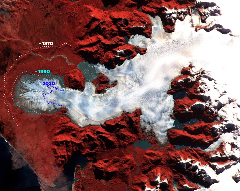
This ASTER false color image (which combines visible and near-infrared wavelengths) shows the San Quintín Glacier, the largest in southern Chile’s Northern Patagonia Icefield, and its iceberg-strewn lakes. Vegetation appears red, lakes and rivers appear dark gray, and the glacier appears white. The terminus locations are after Masiokas et al. (2020) and Winchester and Harrison (1996). Credit: ASTER/ GLIMS

MEaSUREs Greenland Quarterly/Monthly Ice Sheet Velocity Mosaics from SAR and Landsat, Version 5 Datasets Updated

NSIDC DAAC has updated the Making Earth System Data Records for Use in Research Environments (MEaSUREs) Greenland Quarterly Ice Sheet Velocity Mosaics from SAR and Landsat, Version 5 and MEaSUREs Greenland Monthly Ice Sheet Velocity Mosaics from SAR and Landsat, Version 5 datasets. New data have been added, and both datasets now span from December 1, 2014, to November 30, 2024.

These datasets consist of quarterly (three-month interval) and monthly ice velocity mosaics for the Greenland Ice Sheet. The data are derived from Synthetic Aperture Radar (SAR) data, obtained by TerraSAR-X/TanDEM-X and Sentinel-1A and -1B, as well as from optical imagery taken by Landsat 8 and Landsat 9. These datasets are part of the NASA Making Earth System Data Records for Use in Research Environments (MEaSUREs) Program.

Access MEaSUREs data and get more information about these datasets

SMAP Level-4 Version 8 Dataset Updated

NSIDC DAAC updated the Soil Moisture Active Passive (SMAP) Level-4 datasets to Version 8. For all Level-4 data products, data from the entire time series (March 31, 2015, to present) are now available. For each product, SMAP L-band brightness temperature data from descending and ascending half-orbit satellite passes (approximately 6:00 a.m. and 6:00 p.m. local solar time, respectively) are assimilated into a land surface model that is gridded using an Earth-fixed, global cylindrical 9 km Equal-Area Scalable Earth Grid, Version 2.0 (EASE-Grid 2.0) projection. Version 7 data products will be retired on June 30, 2025.

Access SMAP Level-4 Version 8 data and more information about this updated dataset.

Image
Image Caption

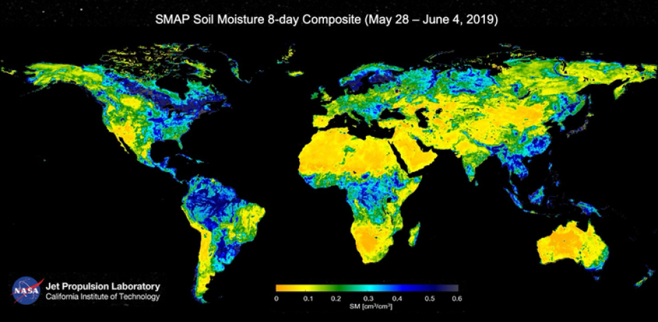
This map shows SMAP observations of global soil moisture from May 28 through June 4, 2019. Areas with the lowest moisture are yellow-orange and areas with the highest moisture are blue-purple. Credit: NASA

NSIDC Adds Several Datasets to the NASA Earthdata Cloud 

NSIDC DAAC added the following datasets to the NASA Earthdata Cloud on these dates:

The Earthdata Cloud HTTPS data access URL is available from each dataset landing page using the HTTPS File System link under “Data Access & Tools.”

For more information about the addition of these datasets to the Earthdata Cloud, click on the links above or see the announcements on the NSIDC website.

MEaSUREs Greenland Image Mosaics and 6- and 12-day Ice Sheet Velocity Mosaics Datasets Updated

The NSIDC has updated the Greenland Image Mosaics from Sentinel-1A and -1B, Version 4 and MEaSUREs Greenland 6- and 12-day Ice Sheet Velocity Mosaics from SAR, Version 2 datasets. New data have been added, and the temporal coverage for both datasets now spans from January 1, 2015, to December 20, 2024. 

Access Greenland Image Mosaics data and more information about these datasets.

NSIDC Retires VIIRS Version 1 Collection 1

The NSIDC DAAC retired the Visible Infrared Imaging Radiometer Suite (VIIRS) Version 1 (Collection 1) datasets on April 8, 2025. This means data from Collection 1 is no longer accessible, but all related documentation will remain available on the dataset web page for future reference. Users are advised to switch to VIIRS Version 2, Collection 2, of these datasets.

Learn more about the VIIRS Version 1 Collection 1 dataset retirement.

Oak Ridge National Laboratory Distributed Active Archive Center (ORNL DAAC)

GEDI L4A Footprint Level Aboveground Biomass Density, Version 2.1

NASA's ORNL DAAC released the Global Ecosystem Dynamics Investigation (GEDI) Level 4A Aboveground Biomass Density, Version 2.1 dataset, which provides predictions of the aboveground biomass density (AGBD) in megagrams per hectare (Mg/ha) and estimates of the prediction standard error within each sampled geolocated laser footprint. In this version, the granules are in sub-orbits and data are reported for the period of April 18, 2019, to November 27, 2024. 

The GEDI instrument consists of three lasers producing a total of eight beam ground transects, which instantaneously sample eight ~25 m footprints spaced approximately every 60 m along-track. The GEDI beam transects are spaced approximately 600 m apart on the Earth's surface in the cross-track direction, for an across-track width of ~4.2 km. Footprint AGBD was derived from parametric models that relate simulated GEDI Level 2A waveform relative height (RH) metrics to field plot estimates of AGBD. For each of the eight beams, additional data are reported with the AGBD estimates, including the associated uncertainty metrics, quality flags, model inputs, and other information about the GEDI Level 2A waveform for this selected algorithm setting group. 

Providing these ancillary data products will allow users to evaluate and select alternative algorithm setting groups. The data product also provides outputs of parameters and variables from the Level 4A models used to generate AGBD predictions that are required as inputs to the algorithm used to generate 1-km gridded products

Access GEDI L4A Footprint Level Aboveground Biomass Density, Version 2.1 data and more information about the dataset.

Image
Image Caption

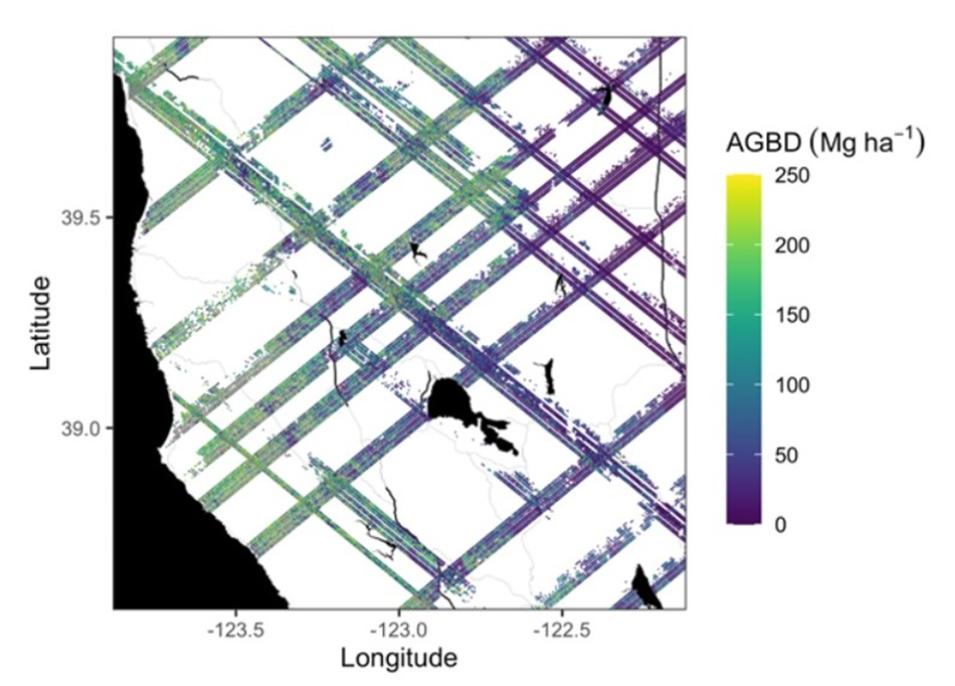
This graphic shows an example subset of aboveground biomass density (AGBD; Mg ha-1) predictions from the GEDI Level-4A footprint product over Northern California spanning April to July 2019. GEDI footprints are spaced 60 m along-track and 600 m across-track. The brighter the color (i.e., green and yellow), the more dense the aboveground biomass. Credit: ORNL DAAC

TM5-4DVAR Global Monthly Source-disaggregated Methane Emissions, 1999-2016 Dataset Available

The TM5 4-Dimensional Variational (TM5-4DVAR) dataset is now available from ORNL DAAC. This dataset provides estimates of methane emissions derived from a dual tracer inversion of atmospheric measurements of methane (CH4) mole fractions and values of methane isotope d13CH4. The measurements were assimilated in the TM5 4-Dimensional Variational (TM5-4DVAR) source-sink inversion system to estimate methane emissions from fossil fuel, microbial, and pyrogenic sources. These estimates include monthly means of methane emissions from each source and all three of these sources combined at 1-degree longitude x 1-degree latitude spatial resolution, and global monthly totals across all global grid cells from each source and all three sources combined from 1999 to 2016. The data are provided in netCDF version 4 format.

Access TM5-4DVAR data and get more information about the dataset.

Passive Microwave-derived Annual Snowoff Date Maps, 1988-2023 Dataset Released

ORNL DAAC released the Passive Microwave-Derived Annual Snowoff Date Maps, 1988-2023 dataset, which provides annual maps of the snowoff (SO) date from 1988-2023 across Alaska and parts of Far East Russia and northwest Canada at a resolution of 6.25 kilometers. 

The spatial domain was intended to match MODIS Alaska Snow Metrics and extend its temporal fidelity beyond the MODIS era. SO date estimates were compared to snow depth measurements collected at SNOTEL stations across Alaska and to three SO datasets derived from MODIS, Landsat, and the Interactive Multisensor Snow and Ice Mapping System (IMS). The data from 1988 to 2016 includes a coastal mask that removes coastal pixels due to potential water contamination from coarse brightness temperature observations.

Access Passive Microwave-Derived Annual Snowoff Date Maps, 1988-2023 data and more information about the dataset.

Image
Image Caption

This graphic shows summary statistics (i.e., mean [left], standard deviation [middle], and coefficient of variation [right]) for the snowoff dates from 1988 to 2016 across across Alaska, parts of Far East Russia, and northwest Canada. Dates are expressed as day of year (DOY). The data from 1988 to 2016 includes a coastal mask that removes coastal pixels due to potential water contamination from coarse brightness temperature observations. Credit: ORNL DAAC

GeoCryoAI Ensemble Learning and the Permafrost Carbon Feedback in Alaska, 1963-2022 Dataset Now Available

The GeoCryoAI Ensemble Learning and the Permafrost Carbon Feedback in Alaska, 1963-2022 dataset is now available from ORNL DAAC. The dataset provides model code, input data, sample results, and documentation for an artificial intelligence-driven model, GeoCryoAI. The dataset includes pre-processed input data (i.e., thaw depth, active layer thickness, thaw subsidence, carbon dioxide flux, and methane flux) acquired from several in-situ measurements, remote sensing platforms, and process-based modeling products.

GeoCryoAI is a hybridized process-constrained ensemble learning framework consisting of stacked convolutionally layered long short-term memory-encoded recurrent neural networks. Its purpose is to quantify permafrost thaw dynamics and greenhouse gas emissions in Alaska.

Access GeoCryoAI data and get more information about the dataset.

ABoVE: Passive Microwave-derived Annual Snowpack Main Melt Onset Date Maps, 1988-2023 Dataset Released

The ORNL DAAC released the Passive Microwave-derived Annual Snowpack Main Melt Onset Date Maps, 1988-2023 dataset from the Artic Boreal Vulnerability Experiment (ABoVE). This dataset provides the annual date of snowpack seasonal beginning melt (i.e., main melt onset date, MMOD) across northwest Canada, Alaska, and parts of far eastern Russia at 6.25-kilometer resolution for the period of 1988 to 2023. MMOD was derived from the daily 19V (K-band) and 37V (Ka-band) GHz bands from the MEaSUREs Calibrated Enhanced-Resolution Passive Microwave (PMW) EASE-Grid Brightness Temperature (Tb) Earth System Data Record (ESDR). The MMOD data record is suitable for documenting the spatial-temporal impacts of MMOD variability in ecosystem services, wildlife movements, and hydrologic processes within the ABoVE domain. The data from 1988 to 2016 included a coastal mask removing coastal pixels due to potential water contamination from coarse brightness temperature observations. No coastal mask is used for the from 2017 to 2023 data. Data users should be aware that values adjacent to large water bodies can be adversely affected.

Access the MMOD Maps dataset and more information.

BlueFlux: Modeled Daily CO2 and CH4 Wetland Fluxes, Southern Florida, 2000-2024 Dataset Available

The Modeled Daily CO2 and CH4 Wetland Fluxes, Southern Florida, 2000-2024 dataset from the NASA Carbon Monitoring System (CMS) BlueFlux Project is now available from ORNL DAAC. This dataset contains gridded estimates of carbon dioxide (CO2) and methane (CH4) fluxes at daily resolution covering the Southern Florida region from 2000 to 2024. Gridded CO2 and CH4 flux prototype products at 500-meter spatial resolution were derived from a machine learning model based on eddy covariance (EC) measurements from 1) airborne fluxes collected seasonally with the NASA Carbon Airborne Flux Experiment over the region during five flight deployments and 2) regional EC tower networks representing long term wetland ecosystem fluxes since 2004. Multiscale flux measurements were upscaled with remote sensing observations of MODIS optical reflectance using a bootstrap ensemble random forest modeling approach to predict daily mean flux intensity and uncertainty from February 2000 to August 2024. Prototypes of modeled, gridded greenhouse gas fluxes were developed as part of the NASA CMS BlueFlux Project. The data are provided in netCDF format.

Access the Modeled Daily CO2 and CH4 Wetland Fluxes, Southern Florida, 2000-2024 dataset and more information.

Image
Image Caption

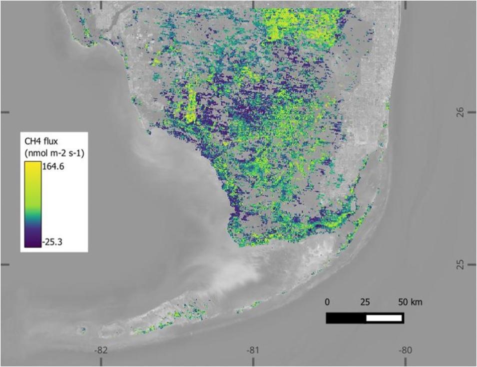
This graphic shows estimates of methane flux (nmol m-2 s-1) from wetlands in southern Florida on June 29, 2000. Methane flux was modeled using a machine learning model based on in-situ and airborne flux measurements paired with MODIS satellite reflectance. Credit: ORNL DAAC

Physical Oceanography Distributed Active Archive Center (PO.DAAC)

NASA-SSH Sea Surface Height Indicators Collections Released

NASA's PO.DAAC released four NASA-SSH Sea Surface Height Indicator datasets, all of which were based on satellite observations of sea surface height anomaly, measured by radar altimeter missions such as TOPEX/Poseidon, the Jason series, and Sentinel-6. The datasets include:

  • Global Mean Sea Level (GMSL)   
  • El Nino-Southern Oscillation (ENSO)  
  • Indian Ocean Dipole (IOD)
  • Pacific Decadal Oscillation (PDO)  

Indicator values were calculated using cyclostationary empirical orthogonal functions on the input data. The data begin in October 1992 and continue through the present. Files for all indicator datasets are distributed in text format. The indicator values were calculated using data from the NASA-SSH Simple Gridded Sea Surface Height from Standardized Reference Missions Only Version 1 dataset. 

Access the NASA-SSH Sea Surface Height Indicator datasets and more information.

Details

Last Updated

Published