NASA Earth Science Data Roundup: August 2023

A summary of datasets, products, and resources released by NASA’s Distributed Active Archive Centers (DAACs) in July 2023.

Alaska Satellite Facility Distributed Active Archive Center (ASF DAAC)

ASF Receives New NASA Contract Award

The Alaska Satellite Facility at the University of Alaska at Fairbanks was recently awarded NASA's Earth Radar Data Operations Management contract for another five years. The contract provides for the continued development and operation of the ASF DAAC for NASA’s Earth Observing System Data and Information System (EOSDIS). ASF DAAC is the home of NASA's collection of synthetic aperture radar (SAR) data. The continued partnership between NASA and ASF aims to enhance data collection, analysis, and distribution processes to advance our understanding of Earth's systems and improve disaster response capabilities.

More information on ASF's new data contract

Atmospheric Science Data Center (ASDC)

Debut of SAGE III Quick Look Data Portal

Image
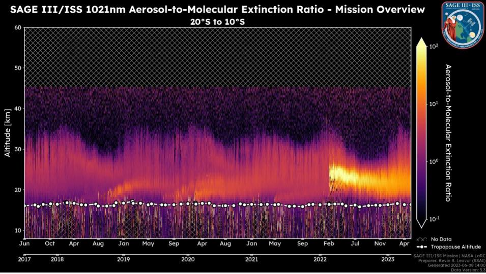
This image from the SAGEIII Quicklook Portal shows the aerosol-to-molecular extinction ratio at various altitudes in the atmosphere. This measurement is used to estimate the concentration and composition of particles present in the air. The purple color indicates lower concentrations while yellow suggests higher concentrations. Credit: NASA ASDC.

NASA's ASDC has announced that, along with the recent release of the Stratospheric Aerosol and Gas Experiment (SAGE) III International Space Station version 5.3 data, the mission has released a portal on the SAGE website that offers public viewing of its SAGE III/ISS Level 2 solar data products.

There are two streams of data to observe: the publicly released data and the expedited pre-release results. The main difference between the two streams is the latency, which is driven by the availability of ancillary meteorological inputs.

SAGE III takes measurements across the globe using a technique called occultation, which involves looking at the light from the Sun or Moon as it passes through Earth's atmosphere at the edge, or limb, of the planet. Every time the Sun (or Moon) rises and sets, SAGE uses the light that passes through the atmosphere to measure gases and particles in that region of the atmosphere.

More information on the SAGE III Quick Look Data Portal

Crustal Dynamics Data Information System (CDDIS)

SLR-Tailored Version of International Terrestrial Reference Frame 2020 Now Available

NASA's CDDIS has announced the release of the Satellite Laser Ranging (SLR) tailored version of the International Terrestrial Reference Frame 2020, the SLRF2020, along with the associated data handling file required for the proper and accurate reduction of SLR data. Both files contain notes that are important to users, especially to those requiring the highest quality results in their work. Users are advised to read these notes before implementing the new Terrestrial Reference Frame in their production lines.

File access and more information on the SLR tailored International Reference Frame 20202

Goddard Earth Sciences Data and Information Services Center (GES DISC)

IMERG Version 7 Final Run Dataset Now Available

Image
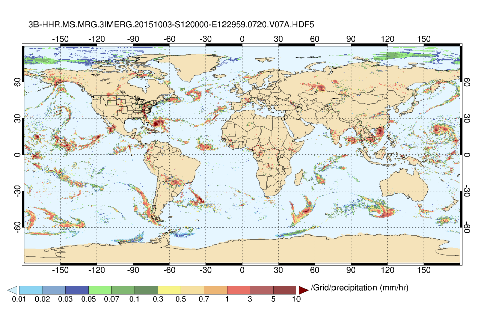
Integrated Multi-satellitE Retrievals for Global Precipitation Measurement Half-Hourly data (IMERGHH) Version 7, for October 3, 2015, at 12:00 UTC. Hurricane Joaquin can be seen approaching the Bahamas (dark red area off the U.S. southeast coast). Credit: NASA GES DISC.

The Global Precipitation Measurement (GPM) Project, the Precipitation Processing System (PPS), and NASA's GES DISC have released Version 7 of the Integrated Multi-satellitE Retrievals for GPM (IMERG) Final Run dataset. The release encompasses three datasets with different temporal resolutions: half-hourly, monthly, and daily. Version 7 of the IMERG near real-time (early and late) products are scheduled for release in fall 2023. 

IMERG V7 data access and more information

Carbon Monitoring System (CMS) GOSAT and ObsPack L4 Dataset Released

NASA's GES DISC and the NASA Carbon Monitoring System (CMS) Project have released Version 1 of the CMS Greenhouse Gases Observing Satellite (GOSAT) and Observation Package (ObsPack) Level 4 top-down yearly methane emissions for individual sectors at 0.5º x 0.625º for North America dataset.

The data product includes methane emissions from 2010 to 2017 by sector in the contiguous United States, Canada, and Mexico by inverse analysis of in-situ and GOSAT atmospheric methane observations. The inversion uses an a priori estimate of the national anthropogenic emission inventories reported to the United Nations Framework Convention on Climate Change for these three countries and serves as an evaluation of these inventories in terms of their magnitudes and trends.

CMS GOSAT/ObsPack L4 data access and more information

NLDAS-2.0 netCDF Data Products Released

Image
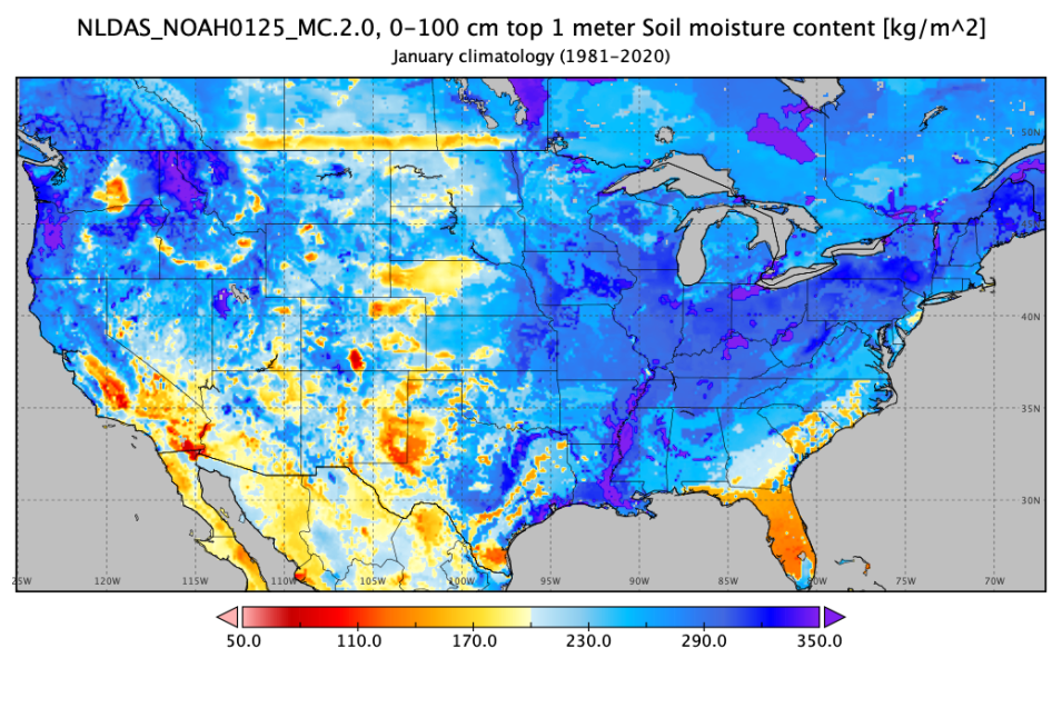
The map of soil moisture content in the first 100 centimeters for the United States comes from NLDAS-2.0 Noah monthly climatology, 0.125°, for January (1981-2020). Credit: NASA GES DISC.

The Hydrological Sciences Laboratory (HSL) at NASA's Goddard Space Flight Center and GES DISC released the North American Land Data Assimilation System Phase 2 (NLDAS-2.0) netCDF data products.

The 15 products include NLDAS hourly, NLDAS monthly, and NLDAS monthly climatology data for the primary and secondary forcing products (FORA and FORB), as well as the Mosaic, Noah, and Variable Infiltration Capacity (VIC) land Surface Models. 

NLDAS-2 is a collaborative project among several groups: the National Center for Environmental Prediction's (NCEP's) Environmental Modeling Center (EMC) and Climate Prediction Center (CPC), NASA's Goddard Space Flight Center, Princeton University, the National Weather Service Office of Hydrologic Development (OHD), and the University of Washington. The NLDAS Project has created surface meteorological forcing datasets using the best-available observations and reanalyses. The forcing datasets are used to drive three separate land-surface models to produce datasets of soil moisture, snow, runoff, and surface fluxes.

NLDAS-2.0 netCDF data access and more information

Land Processes Distributed Active Archive Center (LP DAAC)

MODIS Version 6.0 Land Data Products Decommissioned on July 31

NASA's LP DAAC ceased distribution of Moderate Resolution Imaging Spectroradiometer (MODIS) Version 6.0 land data products on July 31, 2023. This includes all Terra MODIS, Aqua MODIS, and combined Terra-Aqua MODIS datasets with the exception of the Land Water Mask and the Bidirectional Reflectance Distribution Function and Albedo (BRDF/Albedo) Gap-Filled Snow-Free data products. MODIS Version 6.0 data products will no longer be available for search and download from LP DAAC's Data Pool, AppEEARS, NASA's Earthdata Search, or OPeNDAP.

Users are encouraged to transition to MODIS Version 6.1 data products, which offer additional data products that were not available in Version 6.0. The complete list of MODIS Version 6.1 datasets is listed in the MODIS Products Table.

MODIS V6 land data products decommissioned: more information

Image

AppEEARS Version 3.32 Released

Version 3.32 of the Application for Extracting and Exploring Analysis Ready Samples (AppEEARS) is now available. This release includes the addition of USGS Landsat Collection 2 U.S. Analysis Ready Data Surface Reflectance Products. The release also includes a fix to an existing error in the calculation of layer statistics, which may have resulted in an incorrect standard deviation value in the output statistics files for area samples containing layers with additional offset values.

Access AppEEARS

VIIRS Version 2 Vegetation Indices Data Products Released

The Visible Infrared Imaging Radiometer Suite (VIIRS) Version 2 Vegetation Indices product suite release includes data products from both the Suomi National Polar-orbiting Partnership (Suomi NPP) and Joint Polar Satellite System's NOAA-20 satellites and covers the joint mission period from 2018 to the present. Suomi NPP VIIRS Version 1 vegetation indices data products will remain available and will continue with forward processing during this transition.

DVIIRS V2 vegetation indices data access and more information

Level 1 and Atmosphere Archive and Distribution System Distributed Active Archive Center (LAADS DAAC)

MODIS Version 6 and VIIRS C2.0 Level 1 Products Decommissioned

On July 19, 2023, NASA's LAADS DAAC announced the decommissioning of MODIS Version 6.0 Level-1 Land data products from Terra and Aqua and VIIRS Version 2.0 Level 1 data products from the Joint Polar Satellite System's NOAA-20 satellite. Users are advised to transition to the MODIS Version 6.1 and NOAA-20 VIIRS Version 2.1 Level-1 data products as replacements.

More information on MODIS V6 and VIIRS C2.0 products decommissioned

National Snow and Ice Data Center Distributed Active Archive Center (NSIDC DAAC)

Updates to Greenland Mosaic, EASE-Grid Sea Ice Age and Ice Motion, and Unified Level 2B Global Swath Ocean Datasets

Image

MEaSUREs Greenland Image Mosaics from Sentinel-1A and -1B Version 4 Dataset

An update to the Making Earth System Data Records for Use in Research Environments (MEaSUREs) Greenland Image Mosaics from Sentinel-1A and -1B, Version 4 dataset has been released. The data product's temporal coverage now spans from January 1, 2015, to May 24, 2023. The dataset consists of 6- and 12-day, 50-meter resolution image mosaics of the Greenland coastline and ice sheet periphery. The mosaics are derived from C-band Synthetic Aperture Radar data acquired by the Copernicus Sentinel-1A and -1B satellites.

Greenland Image Mosaics from Sentinel-1A and -1B V4 data access and more information

EASE-Grid Sea Ice Age Version 4 Dataset

The EASE-Grid Sea Ice Age, Version 4 dataset, which provides weekly estimates of sea ice age for the Arctic derived from remotely sensed sea ice motion and sea ice extent, has been updated through December 31, 2022.

EASE-Grid Sea Ice Age V4 data access and more information

Polar Pathfinder Daily 25 km EASE-Grid Sea Ice Motion Vectors Dataset

The Polar Pathfinder Daily 25 km EASE-Grid Sea Ice Motion Vectors, Version 4 dataset, which provides daily and weekly sea ice motion vectors including browse images of the weekly data, has been updated through December 31, 2022. The source data used to generate the daily and weekly ice motion estimates are derived from several satellite sensors, International Arctic Buoy Program buoys, and NCEP and National Center for Atmospheric Research (NCAR) reanalysis forecasts.

Polar Pathfinder Daily 25 km EASE-Grid Sea Ice Motion data access and more information

AMSR-E/AMSR2 Unified Level 2B Global Swath Ocean Data Product, Version 1 Dataset

The Advanced Microwave Scanning Radiometer for EOS (AMSR-E) and Advanced Microwave Scanning Radiometer 2 (AMSR2Unified L2B Global Swath Ocean Data Product, Version 1 is being updated to include the AMSR-E portion of the dataset from 2002 to 2011 as well as select AMSR2 data from 2017 to 2021. These files are being delivered to the NSIDC DAAC in batches and will be made available as they are received.

This AMSR Unified global ocean dataset reports integrated water vapor and cloud liquid water content in the atmospheric column, as well as 10-meter sea surface wind speeds. The data are derived from AMSR-E and AMSR2 brightness temperature observations that have been resampled by the Japan Aerospace Exploration Agency to facilitate an intercalibrated (i.e., unified) AMSR-E/AMSR2 data record.

AMSR-E/AMSR2 Unified Level 2B Global Swath Ocean data access and more information

MEaSUREs Calibrated Enhanced-Resolution Passive Microwave Daily EASE-Grid 2.0 Brightness Temperature ESDR, Version 1 Resumes Forward Processing

NSIDC DAAC's MEaSUREs Calibrated Enhanced-Resolution Passive Microwave Daily EASE-Grid 2.0 Brightness Temperature Earth Science Data Record, Version 1 dataset has resumed forward processing. Reprocessing of incomplete files is complete for data from 2023, and reprocessing from December 2021 to December 2022 is ongoing. Corrected files will be added as they become available.

Calibrated Enhanced-Resolution Passive Microwave Daily EASE-Grid 2.0 Brightness Temperature data access and more information

SMAPVEX19-22 Massachusetts and Millbrook Lidar Derived Digital Surface Model, Version 1 Datasets

The Soil Moisture Active Passive Validation Experiment (SMAPVEX) 2019-2022 Massachusetts Lidar Derived Digital Surface Model, Version 1 and SMAPVEX19-22 Millbrook Lidar Derived Digital Surface Model, Version 1 datasets are now available. These data consist of ground surface elevations derived from source lidar measurements collected in August 2022 in the vicinity of Millbrook, New York, and Petersham, Massachusetts, during the SMAPVEX19-22 campaign. This location was chosen due to its forested land cover, as SMAPVEX19-22 aims to validate satellite-derived soil moisture estimates in forested areas. The two acquisition periods occurred to characterize differences during "leaf-on" and "leaf-off" conditions.

SMAPVEX19-22 lidar derived DSM data access and more information

Oak Ridge National Laboratory Distributed Active Archive Center (ORNL DAAC)

ORNL DAAC Releases Forest Disturbance, Carbon Monitoring, and AVIRIS Datasets
Image
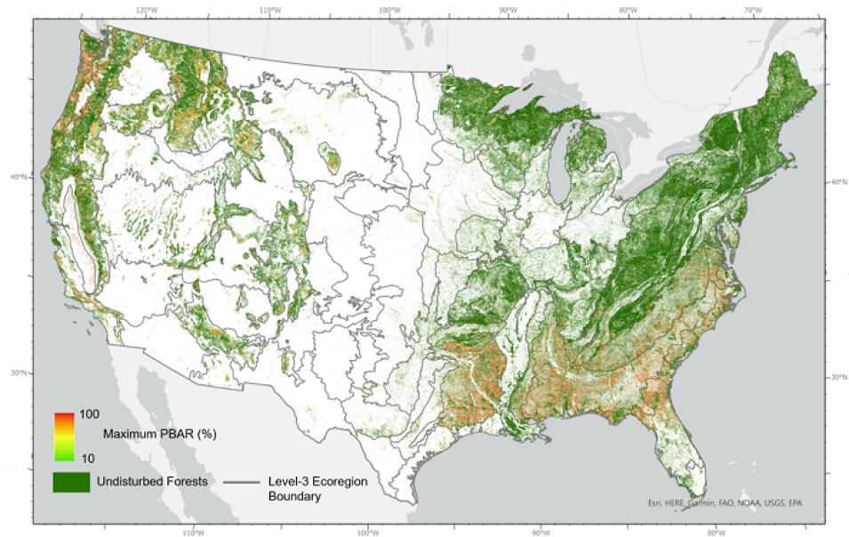
This time-integrated map represents the percentage of basal area removal value, regardless of the disturbance year, for pixel locations where only one disturbance event was detected. The maximum percentage of basal area removal (PBAR) is shown for locations that were disturbed multiple times. Credit: NASA ORNL DAAC.

Forest Disturbance Intensity for the Continental United States

The North American Carbon Program - North American Forest Dynamics Forest Disturbance Intensity for the Continental United States from Landsat 1986-2015 dataset is now available. The dataset contains estimates of forest disturbance intensity for the conterminous United States from 1986 to 2015 and quantifies the intensity and severity of forest disturbances at 30-meter resolution using time series Landsat observations and the vegetation change tracker algorithm. This dataset complements and extends the North American Forest Dynamics-NASA Earth eXchange U.S. Forest Disturbance History dataset and the NAFD-ATT Forest Canopy Cover Loss dataset from 1986-2010 to 1986-2015. Data are provided in Cloud Optimized GeoTIFF format.

Forest disturbance, carbon monitoring and AVIRIS data access and more information

Carbon Monitoring System SIF and Vegetation Indices

The Carbon Monitoring System Solar-Induced chlorophyll Fluorescence (SIF) and Vegetation Indices in the U.S. Midwestern Agroecosystems, 2016-2021 dataset is now available. The dataset covers the years 2016 to 2021 and contains half-hourly ground SIF and vegetation indices, including Normalized Difference Vegetation Index (NDVI), Enhanced Vegetation Index (EVI), red edge chlorophyll index, green chlorophyll index, and photochemical reflectance index at seven crop sites in Nebraska and Illinois. The spectral data for SIF retrieval and hyperspectral reflectance for vegetation index calculation were collected by the FluoSpec2 system, which was installed near planting and uninstalled after harvest to collect whole growing-season data. The data are provided in comma-separated values (CSV) format.

Carbon monitoring SIF and vegetation indices data access and more information

Image
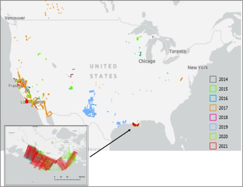
This map shows the location of AVIRIS-NG flight lines in the conterminous United States from 2014 to 2021. Inset shows detail of flight lines by year in coastal Louisiana associated with the Delta-X project. Credit: NASA ORNL DAAC.

AVIRIS Facility Instruments Dataset

ORNL DAAC released the AVIRIS Facility Instruments: Flight Line Geospatial and Contextual Dataset. This product provides attributed geospatial and tabular information for identifying and querying flight lines of interest for the Airborne Visible InfraRed Imaging Spectrometer-Classic (AVIRIS-C) and Airborne Visible InfraRed Imaging Spectrometer-Next Generation (AVIRIS-NG) Facility Instrument collections. It includes an attributed shapefile containing polygon representation of individual flights lines for all years and separate KMZ files for each year, allowing users to visualize and query flight line locations using Geographic Information System (GIS) software. Tables of AVIRIS-C and AVIRIS-NG flight lines with attributed information include dates, bounding coordinates, site names, investigators involved, flight attributes, associated campaigns, and corresponding file names for associated Level 1B (radiance) and Level 2 (reflectance) files in the AVIRIS-C and AVIRIS-NG Facility Instrument collections.

AVIRIS facility insturments data access and more information

AVIRIS-NG L2 Surface Reflectance Dataset

A new AVIRIS-NG L2 Surface Reflectance, Facility Instrument Collection, Version 1 Dataset is now available. This dataset contains AVIRIS-NG Level 2 orthocorrected reflectance from the AVIRIS-NG instrument, which measures reflected radiance at 5-nanometer (nm) intervals in the visible to shortwave infrared spectral range between 380 and 2510 nm. The AVIRIS-NG sensor has a 1 milliradian instantaneous field of view, providing altitude dependent ground sampling distances from 20-meter to submeter range. For each flight line, two types of Level 2 data files may be included: calibrated surface reflectance data and water vapor and optical absorption paths for liquid water and ice data.

AVIRIS-NG L2 surface reflectance data access and more information

Physical Oceanography Distributed Active Archive Center (PO.DAAC)

Sentinel-6 Michael Freilich Level 1A , 1B, and 2 Data Reprocessing Complete

On July 31, 2023, NASA's PO.DAAC released reprocessed Level 1A , Level 1B, and Level 2 altimetry data from the Sentinel-6 Michael Freilich/Jason CS radar altimeter mission. The reprocessed data included in this release cover the time from the start of the mission to the present. These new datasets are considered Version F08 and the corresponding Version 2 datasets are retired as of July 31, 2023. Users are reminded that they should switch to the reprocessed datasets (which are listed at the link below) to obtain non-time critical data from PO.DAAC going forward. Near real-time and short time critical data will continue to be available through the original datasets released for Version F.

The goal of the Sentinel-6 Michael Freilich/Jason CS radar altimeter mission is to provide high-precision measurements of global sea level that build on the extensive record of observations from the previous Jason series altimetry missions. Datasets in this release were processed with the latest Sentinel-6 processing baseline (F08), which has been in use operationally for non time-critical datasets generated since February 2023.

Sentinel-6, L1A, L1B and L2 data access and more information

SMAP Sea Surface Salinity Level 2C Version 5.0 Near Real-Time Dataset from Remote Sensing Systems Now Available

PO.DAAC has released the Level 2C Version 5.0 Near Real-Time (NRT) SMAP Sea Surface Salinity dataset from Remote Sensing Systems. The major differences between the NRT and standard version 5.0 data products are:

  • The use of Level 1B SMAP antenna temperature data
  • The latest 6-hourly 0.25º wind speed and direction are used for the ancillary wind speed and direction inputs
  • Canadian Meteorological Center sea surface temperature data from two days earlier are used for the ancillary sea surface temperature inputs
  • The sea-ice mask of the three-day aggregate remote sensing system AMSR-2 Air-Sea Essential Climate Variables dataset from two days earlier is used for the sea-ice flag
  • No correction for sea-ice contamination is performed, therefore it is recommended that users only incorporate SMAP data that are classified to be within sea-ice zone 0 for open ocean scene and no sea-ice contamination

SMAP sea surface salinity L2C data access and more information

Image
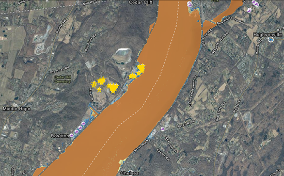
The map shows a power plant and a wastewater facility in Newburgh, New York, that, under certain flooding scenarios, would be inundated with 2 to 4 inches of water from the nearby Hudson River. Credit: NASA SEDAC.

Socioeconomic Data and Applications Center (SEDAC)

SEDAC Develops New York State Flood Impact Support System Application

NASA's SEDAC has announced the release of the New York State Flood Impact Support System (NYS FIDSS) application, a new mapping tool designed to increase flood planning capacity in New York State.

Developed by SEDAC and based on results from the New York State Building Footprints with Flood Analysis project, NYS FIDSS visualizes building footprint data for nearly all the state's infrastructure, with the exception of New York City.

The mapper includes the U.S. Social Vulnerability Index Grids dataset developed by SEDAC and based on the U.S. Centers for Disease Control and Prevention's Social Vulnerability Index, which lets users visualize relative social vulnerability for areas impacted by flooding. In addition, the NYS FIDSS mapper's easy-to-use interface aligns with the aims of NASA's Transform to Open Science (TOPS) initiative to more openly share software, data, and knowledge to advance inclusiveness and improve social justice.

SEDAC NYS Flood Impact Support System tool access and more information