Earth Science Data Roundup: March 2024
This data visualization from the TEMPO mission shows high levels of nitrogen dioxide over multiple urban areas across the U.S., Canada, Mexico, and the Caribbean (indicated by red/tan colored areas). Detailed views of these regions show high levels of nitrogen dioxide over cities in the morning and enhanced levels of nitrogen dioxide over major highways. Credit: NASA's SVS.
NASA's ASDC released a suite of beta Level 1 data products from the Tropospheric Emissions: Monitoring of POllution (TEMPO) mission. Among the products included in this release are:
- TEMPO Level 1B (Beta) Geolocated Earth Radiance (TEMPO_RAD_L1 V02)
- TEMPO Level 1A (Beta) Dark Exposure (TEMPO_DRK_L1 V02)
- TEMPO Level 1B (Beta) Solar Irradiance (TEMPO_IRR_L1 V02)
- TEMPO Level 1B (Beta) Solar Irradiance (TEMPO_IRRR_L1 V02; available March 2024)
The Level 1 Geolocated Earth Radiance and Solar Irradiance products contain information on radiometrically- and wavelength-calibrated Earth radiance/solar irradiance for the ultraviolet (UV) and visible bands, corresponding noise, parameterized wavelength grid, viewing geometry, quality flags, and other ancillary information.
The Level 1A Dark Exposure product contains information on dark current rates of all frames and their average for the UV and visible bands, pixel quality flags, and other ancillary information.
All four data products are provided in netCDF4 format and are designated at a beta maturity level, which means the products are minimally validated and may contain errors. Users should refrain from making conclusive public statements regarding science and applications of these data products until a product is designated at the provisional validation status.
Data access and more information about the TEMPO beta data products
SAGE III Mission on the International Space Station Releases Level 2 Aerosol Auxiliary Product
A new Level 2 aerosol auxiliary product from the Stratospheric Aerosol and Gas Experiment III (SAGE III) mission on the International Space Station provides long-term monitoring of ozone vertical profiles of the stratosphere and mesosphere. The data include key components of atmospheric composition and their long-term variability, and aid the study of aerosols, chlorine dioxide, clouds, nitrogen dioxide, nitrogen trioxide, pressure and temperature, and water vapor.
Data access and more information about the SAGE III aerosol product
CALIPSO Mission Releases Level 2 Blowing Snow Products
Two new Cloud-Aerosol Lidar with Orthogonal Polarization (CALIOP) Level 2 monthly data products from the Cloud-Aerosol Lidar and Infrared Pathfinder Satellite (CALIPSO) mission are available from ASDC. The products are CAL_LID_L2_BlowingSnow_Greenland-Standard-V1-00 and CAL_LID_L2_BlowingSnow_Antarctica-Standard-V2-00.
These products allow users to isolate blowing snow events determined from CALIOP lidar atmospheric attenuated backscatter measurements and obtain the spatial and temporal frequency, layer height, and optical depth of these events over Antarctica (updated version 2.00) and Greenland (new version 1.00). The data cover the period from June 2006 through June 2023.
Data access and more information about the CALIPSO snow products
Goddard Earth Sciences Data and Information Services Center (GES DISC)
TROPICS Mission Releases Pathfinder, Provisional Data Products
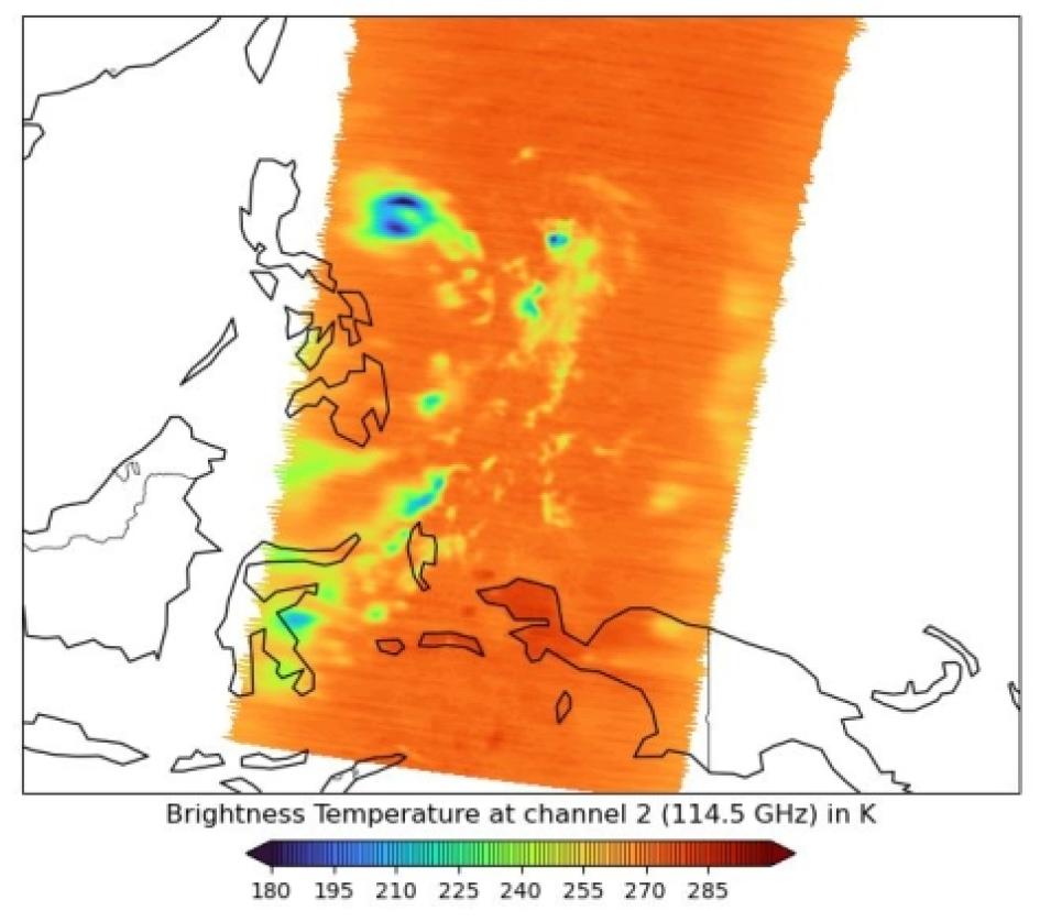
New pathfinder stage 2 provisional data from the Time-Resolved Observations of Precipitation structure and storm Intensity with a Constellation of SmallSats (TROPICS) mission are available through NASA's GES DISC. The mission uses the TROPICS Millimeter-wave Sounder (TMS) to observe tropical cyclone thermodynamics and structural features with 12 channels spanning the W (water droplets), F (temperature profile), and G (moisture profile) microwave bands.
This provisional stage 2 data product maturity release consists of data from the first TROPICS CubeSat (TROPICS-01) launched in June 2021. Among the data products included in this release are:
- Level 1A Antenna Temperature Products (TROPICS01ANTTL1A_1.0) providing geolocated antenna temperatures (radiance) in units of kelvins that are timestamped to Universal Coordinated Time (UTC) and are reported at native spatial resolutions
- Level 1B Brightness Temperature Products (TROPICS01BRTTL1B_1.0) offering geolocated brightness temperatures (radiance) in units of Kelvins that are timestamped to UTC and are reported at native spatial resolutions
- Level 2A Unified Resolution Radiometric Products (TROPICS01URADL2A_1.0) providing geolocated brightness temperature with the water vapor sounding channels converted from their native G-band resolution to the temperature sounding channel (F-band)
Provisional data product maturity is defined by NASA as a data product that is ready to "facilitate data exploration and process studies that do not require rigorous validation. These data are partially validated, and improvements are continuing; quality may not be optimal since validation and quality assurance are ongoing."
Data access and more information about the TROPICS provisional products
TROPICS Provisional Brightness and Antenna Temperature Products Released
Six provisional datasets from the TROPICS mission's TROPICS03 and 06 CubeSats are now available. Among the data products included in this provisional release are:
- Level 1A Antenna Temperature Products: TROPICS03ANTTL1A_0.2 and TROPICS06ANTTL1A_0.2
- Level 1B Brightness Temperature Products: TROPICS03BRTTL1B_0.2 and TROPICS06BRTTL1B_0.2
- Level 2A Unified Resolution Radiometric Products: TROPICS03URADL2A_0.2 and TROPICS06URADL2A_0.2
Data access and more information about the TROPICS brightness and antenna temperature products
NOAA-21 CrIS Level 1B Beta Version 3 Data Products Released
GES DISC, the Cross-track Infrared Sounder (CrIS) Level 1B Sounder Development Team at the University of Wisconsin, and NASA's Jet Propulsion Laboratory Sounder Science Investigator-led Processing System (SIPS) released CrIS Level 1B Beta Version 3 data products created from data acquired by the NOAA-21 satellite. These beta products were created to allow users to begin working with data from the CrIS instrument aboard the NOAA-21 satellite, which launched on November 10, 2022.
Data access and more information about the CrIS products
TROPESS Chemical Reanalysis Products Released
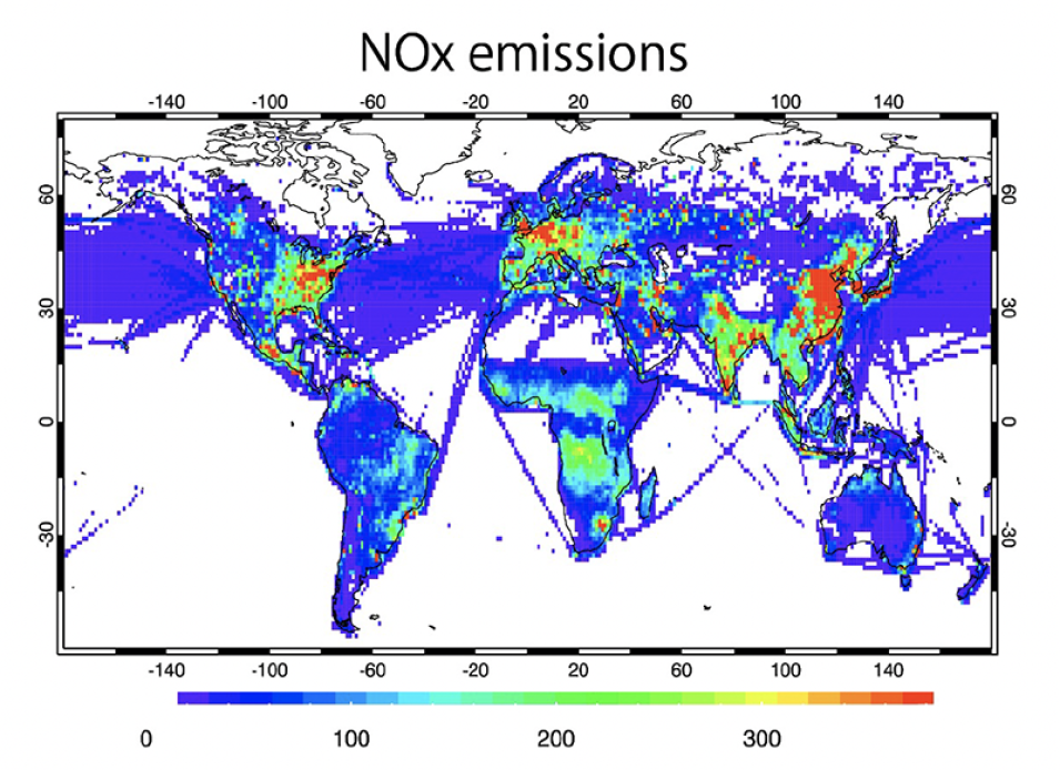
This visualization of TROPESS Chemistry Reanalysis Version 2 data shows global distributions of surface NOx emissions averaged over the period of 2005 to 2018. Yellow, orange, and red colors indicate higher NOx concentrations. Credit: NASA JPL SSW, Miyazaki, et al. 2020b. doi:10.5194/essd-12-2223-2020
GES DISC released the NASA TRopospheric Ozone and Precursors from Earth System Sounding (TROPESS) Chemistry Reanalysis Version 2 (TCR-2) datasets for trace gasses. These gases include ozone (O3), carbon monoxide (CO), hydroxide (OH), sulfur dioxide (SO2), peroxyacetyl nitrate (PAN), nitric acid (HNO3), nitric oxide (NO), nitrogen dioxide (NO2), formaldehyde (CH2O), aerosols (SO4, NH4, and NO3), and emission sources of nitrogen oxide (NOx), CO, and SO2.
The TCR-2 datasets include 3D atmospheric concentrations (horizontal distributions and vertical profiles), 3D model and data assimilation diagnostic information, and 2D emissions (horizontal distributions) at various time scales.
The TCR-2 data coverage time period is January 1, 2005, to December 31, 2021. The TCR-2 products are written in netCDF4 format and provide global coverage with 2-hourly, 6-hourly, and monthly averages at a grid resolution of 1.125º latitude x 1.125º longitude. The data are reported at a range of 27 vertical levels from the surface (1000 hPa) to 60 hPa.
Data access and more information about the TROPESS reanalysis products
GES DISC Publishes Historical Geodesy Data from GEOS-2 and GEOS-3 Satellites
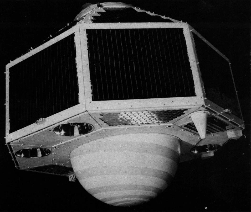
Two datasets from the Geodetic Earth Orbiting Satellite (GEOS-2) and the Geodynamics Experimental Ocean Satellite (GEOS-3) missions are available through NASA's GES DISC.
The GEOS-2 International Optical Beacon Data Input V001 dataset contains reduced raw geodetic optical observations obtained by various international camera systems. These data were used as inputs to create the product called the International Optical Beacon Pass Summary Data. The optical beacon system, which was used for geometric geodesy studies, consisted of four xenon flash tubes programmed to flash sequentially in a series of five or seven flashes. Data are available for the time period from February 20,1968, to October 3,1968, in a single file with 1,689 data records, where each record is a line of ASCII text.
The GEOS-3 Satellite-to-Satellite Tracking Data dataset offers a satellite-to-satellite tracking data product that contains observations used for geodetic studies. Data are available for the time period from April 13,1975, to April 28,1976, in 16 ASCII text files, where each measurement is recorded as two lines of text.
Data access and more information about the GEOS historical data
Land Processes Distributed Active Archive Center (LP DAAC)
MODIS/Terra Land Water Mask (Version 6.1) Dataset Released
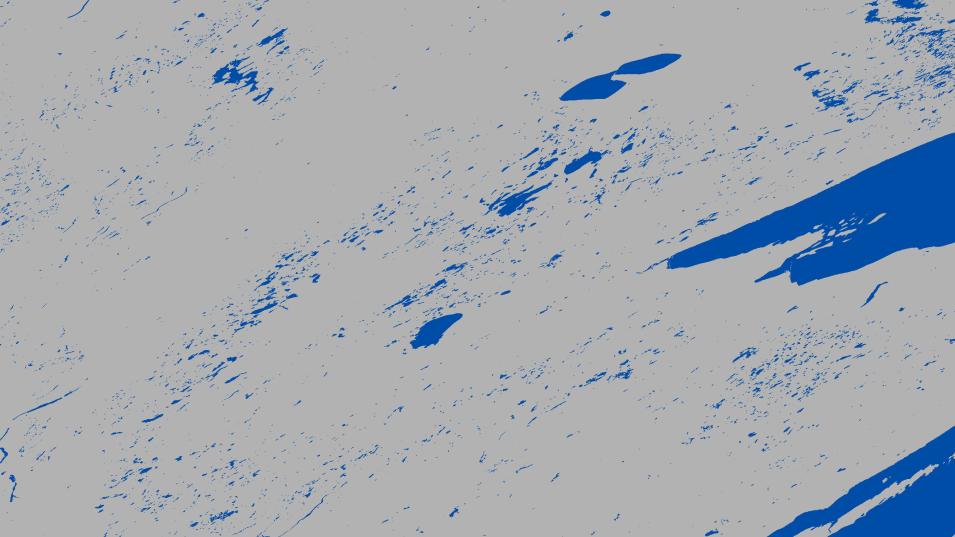
NASA's LP DAAC released an updated Land Water Mask dataset (Version 6.1) derived from the Moderate Resolution Imaging Spectroradiometer (MODIS)/Terra and Shuttle Radar Topography Mission (SRTM) Level 3 Global 250-meter SIN Grid product. This data product provides a global yearly water mask at a 250-meter resolution in yearly intervals from 2000 to 2023. Layers include land/water mask, water body classification, and quality assurance.
Access to MODIS/Terra land water mask data
National Snow and Ice Data Center DAAC (NSIDC DAAC)
Multiple ATLAS/ICESat-2 Datasets Retiring
The Advanced Topographic Laser Altimeter System (ATLAS)/Ice, Cloud, and land Elevation Satellite-2 (ICESat-2) Level 3B Monthly Gridded Dynamic Ocean Topography (ATL19) and ATLAS/ICESat-2 Level 3B Mean Inland Surface Water Data (ATL22), Version 2 datasets will be retired on March 12, 2024.
After this date, access to these data will no longer be available. Dataset documentation will remain accessible for future reference. NSIDC recommends that users transition to the latest versions of these datasets, which are available via the "more recent version" links on the NSIDC DAAC dataset landing pages. Version-specific details can be found under "Version Summary" on each dataset's landing page.
More information about the retirement of the ATLAS datasets
IceBridge LVIS Level 1B Geolocated Return Energy Waveforms, Version 2 Released
NSIDC DAAC released Version 2 of the IceBridge Land, Vegetation, and Ice Sensor (LVIS) Level 1B Geolocated Return Energy Waveforms dataset, which now includes data from April 14, 2009, to May 10, 2012. This dataset provides return energy waveform data measured over Greenland, Alaska, and Antarctica by NASA's LVIS instrument, an airborne lidar scanning laser altimeter. Temporal coverage now spans April 14, 2009, to September 20, 2017; Version 2 data are provided in HDF5 format.
Version 1 of this dataset, which has binary files covering April 14, 2009, to May 10, 2012, will be retired from the NSIDC DAAC on March 18, 2024. Upon retirement, data will no longer be accessible, but all related documentation will remain available on the Version 1 dataset page for future reference.
Data access and more information about the IceBridge LVIS waveforms dataset
Dataset Update: IceBridge LVIS Level 1A Geotagged Images
The IceBridge LVIS Level 1A Geotagged Images, Version 1 dataset has been expanded with the addition of more than 100,000 images from the 2015 southern hemisphere campaign. This dataset contains geotagged images acquired over Greenland and Antarctica by the NASA Digital Mapping Camera paired with the LVIS airborne lidar scanning laser altimeter.
Data access and more information about the IceBridge LVIS geotagged images
ICESat-2 Boreal Aboveground Biomass Density Dataset
The ICESat-2 Derived 30 Meter Along-Track Boreal Aboveground Biomass Density, Version 01 dataset is now available through NASA's NSIDC DAAC. This dataset provides a quality-filtered set of ATLAS/ICESat-2 Level 3A Land and Vegetation Height (ATL08), Version 5 observations of relative canopy heights and aboveground biomass density model results for circumpolar boreal forests. The data were collected at 30-meter along-track segment lengths during the 2019 to 2021 high northern latitude growing seasons.
Data access and more information about the ICESat-2 biomass density dataset
SnowEx23 Bonanza Creek Lidar Scans Available
SnowEx23 Bonanza Creek Experimental Forest Terrestrial Lidar Scans, Version 1 and SnowEx23 Bonanza Creek Experimental Forest Terrestrial Lidar Scans Raw, Version 1 datasets are now available. These datasets contain digital terrain models (DTMs) derived from terrestrial lidar scans (TLS) collected as part of the SnowEx 2023 campaign and the unprocessed point cloud data from which these DTMs were derived. Data were collected at the Bonanza Creek Experimental Forest near Fairbanks, Alaska, in October 2022 (snow-off conditions) and March 2023 (snow-on conditions).
Access to SnowEx23 Bonanza Creek lidar data
SnowEx Colorado Snow Depth Time Series and DEMs Now Available
The SnowEx Colorado 3-Meter Snow Depth Time Series and DEMs from High-Resolution Satellite Image Pairs, Version 1 dataset is now available. This dataset contains a time series of snow depth maps and related intermediary snow-on and snow-off digital elevation models for Grand Mesa, Colorado, derived from very-high-resolution satellite stereo images and lidar point cloud data. Temporal coverage spans the dates of February 19, 2016, to March 2, 2022.
Access to SnowEx Colorado snow depth and DEM data
Greenland Glacier Dataset Released
The Automated Greenland Glacier Termini Position Time Series, Version 1 dataset is now available from NASA's NSIDC DAAC. This dataset contains shapefiles of termini traces from 294 Greenland glaciers, derived using a deep learning algorithm applied to satellite imagery. Also available are supplementary data, including temporal coverage of termini traces, time series data of termini variations, and updated land, ocean, and ice masks derived from the Greenland Ice Sheet Mapping Project (GrIMP) ice masks. Temporal coverage spans from January 1, 1972, to January 1, 2022.
Access to Greenland glacier time series data
Oak Ridge National Laboratory DAAC (ORNL DAAC)
New ABoVE Soil Properties Dataset
NASA's ORNL DAAC released a new Arctic-Boreal Vulnerability Experiment (ABoVE) dataset that provides lab-measured soil properties, including soil water matric potential, soil dielectric properties, soil electrical conductivity, and corresponding soil moisture. The dataset also includes information on the basic physical properties of the soils, such as soil organic matter, bulk density, porosity, fiber content, root biomass, and mineral texture.
Soil samples were collected from August 21 to August 27, 2018, from the surface to permafrost table in soil pits at nine sites along the Dalton Highway in the northern and central regions of Alaska. The purpose of the soil collection and lab measurements is to develop an integrated framework that relates the hydrological properties to the dielectric properties of permafrost active layer soil in support of the NASA ABoVE Airborne Campaign.
Data access and more information about the ABoVE soil properties dataset
Post-fire Recovery of Soil Organic Layer Carbon Dataset
The Post-fire Recovery of Soil Organic Layer Carbon in Canadian Boreal Forests, 2015-2018 dataset is now available at NASA's ORNL DAAC. The dataset provides observations of site moisture, soil organic layer thickness, soil organic carbon, nonvascular plant functional group, stand dominance, ecozone, time-after-fire, jack pine proportion, and deciduous proportion for 511 forested plots spanning approximately 140,000 square kilometers across two ecozones in Canada's Northwest Territories. Data are for the period of November 6, 2015, to August 24, 2018, and are provided in comma-separated values (CSV) format.
Data access and more information about the post-fire recovery dataset
Physical Oceanography DAAC (PO.DAAC)
SASSIE Arctic Field Campaign Datasets Released
NASA's PO.DAAC released datasets from the Salinity and Stratification at the Sea Ice Edge (SASSIE) 2022 Arctic Field Experiment. From August to October 2022, a suite of autonomous and shipboard instruments was deployed in the Beaufort Sea to measure how summer sea ice melt contributes to subsequent winter sea ice formation. Measurements include near-surface salinity, conductivity, ocean temperature, pressure, surface winds, atmospheric temperature, radiative flux, and precipitation.
Data access and more information about the SASSIE datasets
SWOT Geophysical Data Record Released
PO.DAAC released Level 2 geophysical data record (GDR) products from the onboard nadir altimeter (NALT) and the advanced microwave radiometer (AMR) instruments aboard the Surface Water and Ocean Topography (SWOT) satellite mission.
NALT is a Jason-class dual frequency (Ku/C) altimeter that provides measurements of sea surface height, significant wave height, and wind speed. Data are available with latency of < 90 days. AMR is a Jason-class radiometer, but with two active strings that facilitate measurements on the left and right sides of the satellite nadir point. It provides measurements of wet troposphere content, atmospheric attenuation to backscatter, cloud liquid water, water vapor content, and wind speed. AMR data are available with latency of < 90 days.
Data access and more information about the SWOT geophysical data record products
Socioeconomic Data and Applications Center (SEDAC)
U.S. Ozone Concentrations Dataset Available
NASA's SEDAC released a Daily 8-Hour Maximum and Annual Ozone (O3) Concentrations for the Contiguous United States, 1-kilometer (km) Grids, Version 1.10 (2000-2016) dataset. The dataset contains estimates of O3 concentrations at high spatial and temporal resolutions for the years 2000 to 2016.
These predictions incorporate various predictor variables such as ozone ground measurements from the U.S. Environmental Protection Agency (EPA) Air Quality System (AQS) monitoring data, land-use variables, meteorological variables, chemical transport models, and remote sensing data, along with other data sources. The data are available in RDS and GeoTIFF formats for statistical research and geospatial analysis.
This map from SEDAC's Country Trends in Major Air Pollutants dataset (part of the Air Quality for Health-Related Applications collection) shows country changes in ozone in parts per million from the average ozone for the years 2003, 2004, and 2005 to the average ozone for the years 2016, 2017, and 2018. Credit: NASA's SEDAC.
Data access and more information about the SEDAC ozone concentrations dataset
New Daily and Annual U.S. PM2.5 Concentrations Dataset
SEDAC released a Daily and Annual PM2.5 Concentrations for the Contiguous United States, 1-km Grids, Version 1.10 (2000-2016) dataset that includes predictions of PM2.5 concentration in grid cells at a resolution of 1-km for the years 2000 to 2016. The data are available in RDS and GeoTIFF formats for statistical research and geospatial analysis.
Data access and more information about the PM2.5 concentrations dataset
U.S. Daily and Annual Nitrogen Dioxide Concentrations Dataset Now Available
A Daily and Annual Nitrogen Dioxide (NO2) Concentrations for the Contiguous United States, 1-km Grids, Version 1.10 (2000-2016) dataset is available at SEDAC. The dataset contains daily predictions of NO2 concentrations at a high resolution (1-km grid cells) for the years 2000 to 2016. The data are available in RDS and GeoTIFF formats for statistical research and geospatial analysis.
Data access and more information about the nitrogen dioxide concentrations dataset


