Salt is essential to life on Earth and is constantly circulating through our bodies and the global ocean. The amount of salt dissolved in seawater, referred to as salinity, impacts Earth’s climate by dispersing heat and carbon around the planet. The impact on ocean circulation makes sea salinity an important variable for a range of studies related to the global water cycle, ocean-atmosphere interactions, and climate change.
Addressing Needs for Sea Surface Salinity Data
Observations of sea surface salinity (SSS) were identified by the Satellite Needs Working Group (SNWG) as a direct requirement in key responsibilities of several U.S. Government agencies. The SNWG is an interagency effort across civilian U.S. government agencies that seeks to identify and address the need for satellite data and products among participating federal agencies.
Assessment of the 2020 SNWG surveys revealed a need for SSS observations. Specifically, low-latency measurements of SSS near the sea-ice edge were requested for various operational efforts including the development and improvement of ocean forecasting systems. These areas were masked out in NASA’s existing salinity products because pixels that have both sea ice and open water have larger measurement uncertainties than open water alone.
To help address this need, NASA’s Physical Oceanography Distributed Active Archive Center (PO.DAAC) recently released Version 5.0 SMAP SSS data from Remote Sensing Systems (RSS), which is part of NASA’s Ocean Salinity Science Team (OSST) effort. The Soil Moisture Active Passive mission, or SMAP, is a NASA satellite equipped with a radiometer designed to measure soil moisture but is also applicable to measuring SSS.
The radiometer, which has operated flawlessly since launch in 2015, measures microwave radiation emitted from the sea surface at a frequency that is sensitive to SSS. The version 5.0 SMAP SSS datasets include flags that allow users identify the sea-ice fraction in each pixel and include a novel correction for sea-ice contamination.
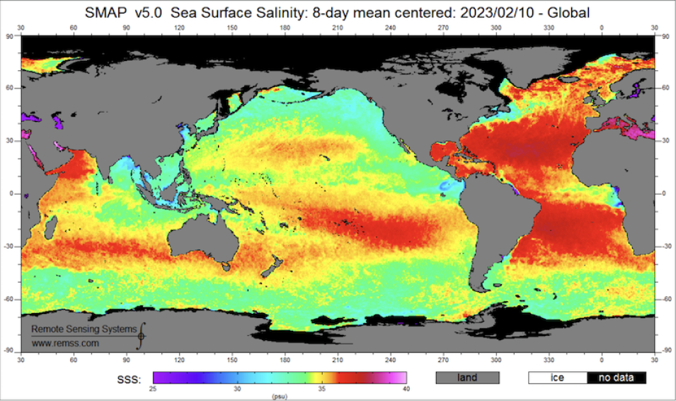
Global SSS from the SMAP Version 5.0 product. Red/yellow indicates higher salinity values measured in practical salinity units (psu). The average ocean salinity is 34.7 psu (green areas). Red indicates areas of higher SSS. Credit: Remote Sensing Systems; accessed February 25, 2023.
The SMAP SSS datasets released by PO.DAAC will provide information essential to studies of the global water cycle, ocean-atmosphere interactions, and climate change. Salinity is determined by near-surface mixing and water buoyancy, which strongly influences ocean-atmosphere processes such as the flux of heat and moisture. Consequently, SSS data are a key parameter in environmental and climate predictions.
Furthermore, changes in salinity driven by the difference between evaporation and precipitation serve as indicators for the ocean component of the global water cycle. In addition, salinity-influenced processes significantly affect ecosystems, both dynamically and chemically, which makes salinity data from satellites essential for ecological forecasting. The result is that the new SSS datasets will advance our understanding of not just the salinity of oceans but of the global water cycle and climate change.
The SSS datasets and the associated technical documentation are described, discoverable, and accessible via the PO.DAAC data portal, and data can be discovered and downloaded using Earthdata Search. General information regarding the SMAP mission is available from the mission website and via PO.DAAC’s SMAP and salinity webpages.
NASA oversees the biennial SNWG assessment process through the SNWG Management Office, which is part of NASA’s Interagency Implementation and Advanced Concepts Team (IMPACT). IMPACT is a component of NASA’s Earth Science Data Systems (ESDS) Program.

