We are in the process of migrating all NASA Earth science data sites into Earthdata from now until end of 2026. Not all NASA Earth science data and resources will appear here until then. Thank you for your patience as we make this transition.
Read about the Web Unification Project
Filters
Researchers used ECCO data to understand the mechanisms behind changes in salinity of the Southeast Indian Ocean.
Data in Action
June 5, 2026

The first named storm of the hurricane season appears in this nighttime image from June 3, 2026.
Worldview Image of the Week
June 5, 2026

This virtualized data representation of the SWOT version D Basic time series allows users to access and download only the parts they want.
News
June 5, 2026

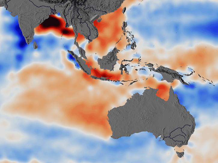
Data and reanalysis models from May 2026 show signs that an El Niño event may be developing.
Worldview Image of the Week
May 29, 2026

The VIIRS instrument aboard NOAA-21 acquired data for a time-lapse animation of the fire in this national park.
Worldview Image of the Week
May 22, 2026

Data from the Harmonized Landsat and Sentinel-2 product and Worldview captured the change of seasons.
Worldview Image of the Week
May 15, 2026

The NLDAS-2 dataset was added to the AIMS decision-making platform to create hydrology and water quality simulations for farmers and land managers across the country.
News
May 14, 2026

Arctic river discharge plays a key role in controlling early fall sea ice formation in the Beaufort Sea.
Data in Action
May 13, 2026
SHOWING 8 OF 2377