We are in the process of migrating all NASA Earth science data sites into Earthdata from now until end of 2026. Not all NASA Earth science data and resources will appear here until then. Thank you for your patience as we make this transition.
Read about the Web Unification Project
Aeolian Landforms Data Access and Tools
From discovery to visualization, data tools such as OpenAltimetry, Earthdata Search, and Worldview guide users in making the most of aeolian landform data.
Aeolian Landforms Datasets
| Dataset Sort descending | Version | Platforms | Instruments | Temporal Extent | Spatial Extent | Spatial Resolution | Data Format |
|---|---|---|---|---|---|---|---|
| ALOS PALSAR High Resolution Radiometric Terrain Corrected Product | 1 | ALOS | PALSAR | 2006-03-23 to 2011-04-22 |
N: 90 S: -90 E: 180 W: -180 |
||
| ALOS PALSAR Level 1.0 Product | 1 | ALOS | PALSAR | 2006-03-23 to 2011-04-22 |
N: 90 S: -90 E: 180 W: -180 |
||
| ALOS PALSAR Level 1.1 Product | 1 | ALOS | PALSAR | 2006-01-23 to 2011-05-23 |
N: 90 S: -90 E: 180 W: -180 |
||
| ALOS PALSAR Level 1.5 Product | 1 | ALOS | PALSAR | 2006-03-23 to 2011-04-22 |
N: 90 S: -90 E: 180 W: -180 |
||
| ALOS PALSAR Level 2.2 Product | 1 | ALOS | PALSAR | 2006-01-23 to 2011-05-23 |
N: 90 S: -90 E: 180 W: -180 |
||
| ALOS PALSAR Low Resolution Radiometric Terrain Corrected Product | 1 | ALOS | PALSAR | 2006-03-23 to 2011-04-22 |
N: 90 S: -90 E: 180 W: -180 |
||
| Geobotanical and Impact Map Collection for Prudhoe Bay Oilfield, Alaska, 1972-2010 | 1 | FIELD SURVEYS, FIELD INVESTIGATION, LANDSAT | 1949-01-01 to 2010-07-31 |
N: 71.0271 S: 69.9702 E: -146.974 W: -150.167 |
multiple | ||
| JERS-1 Level 0 Product | 1 | JERS-1 | SAR | 1992-05-20 to 1998-10-11 |
N: 90 S: -90 E: 180 W: -180 |
||
| JERS-1 Level 1 Product | 1 | JERS-1 | SAR | 1992-05-20 to 1998-10-11 |
N: 90 S: -90 E: 180 W: -180 |
||
| KMZ for ALOS PALSAR Radiometric Terrain Corrected Product | 1 | ALOS | PALSAR | 2006-03-23 to 2011-04-22 |
N: 90 S: -90 E: 180 W: -180 |
SHOWING 10 OF 40
Featured Aeolian Landforms Observation Method: ATLAS
NASA's Advanced Topographic Laser Altimeter System (ATLAS) is a laser altimeter aboard the Ice, Cloud, and Land Elevation Satellite-2 (ICESat-2) platform. While the primary intent of ATLAS is to measure cryospheric elevation, the instrument is able to measure elevation in temperate regions as well.

Expedited elevation data from the Advanced Topographic Altimeter System (ATLAS) instrument are available through Land, Atmosphere Near real-time Capability for Earth observation (LANCE).

This Satellite Needs Working Group solution provides reduced-latency versions of existing Ice, Cloud, and land Elevation Satellite-2 (ICESat-2) Advanced Topographic Laser Altimeter System (ATLAS) products.
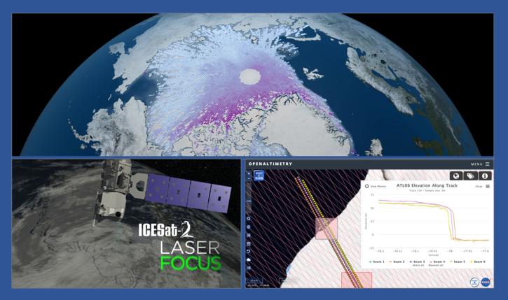
During this webinar we will introduce the ICESat-2 mission and show you how to explore, access and customize ICESat-2 data with the advanced discovery and visualization OpenAltimetry application, directly filter and access ICESat-2 data from an NSIDC DAAC data set page and subset, reformat and analyze ICESat-2 data using Python-based resources.

Data from NASA’s ICESat-2 mission provide incredibly accurate measurements of Earth elevation change—and much more.
8 MIN READ
Aeolian Landforms Data Tools
| Tool Sort descending | Description | Services | |
|---|---|---|---|
| Earthdata Search | Earthdata Search enables data discovery, search, comparison, visualization, and access across NASA’s Earth science data holdings. | Search and Discovery, Access, Cataloging, Cloud Computing, Downloading | |
| Worldview | Worldview offers the capability to interactively browse over 1,200 global, full-resolution satellite imagery layers and download the underlying data. | Analysis, Search and Discovery, Visualization, Access, Comparison, Monitoring Natural Events |
SHOWING 2 OF 2
Frequently Asked Questions
Earthdata Forum
Our online forum provides a space for users to browse thousands of FAQs about research needs, data, and data applications. You can also submit new questions for our experts to answer.
Submit Questions to Earthdata Forumand View Expert Responses