We are in the process of migrating all NASA Earth science data sites into Earthdata from now until end of 2026. Not all NASA Earth science data and resources will appear here until then. Thank you for your patience as we make this transition.
Read about the Web Unification Project
Landslides News
Articles, resources, and announcements from Landslides.
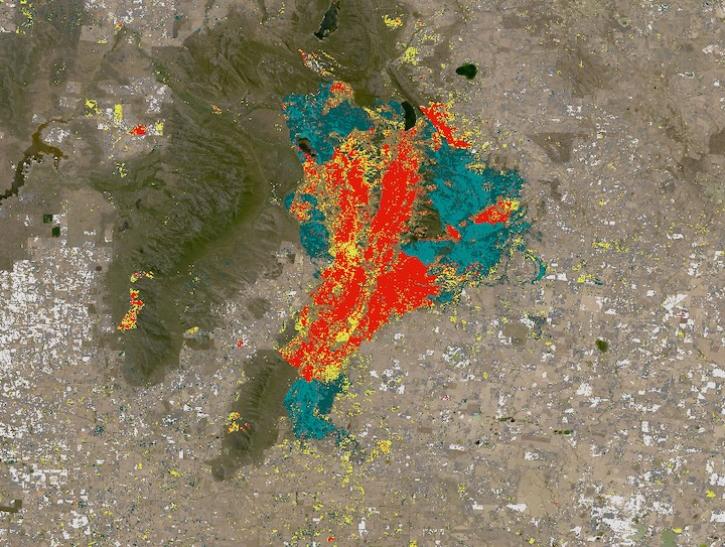
Explore OPERA’s near-global land surface disturbance at 30-meter resolution.
News
June 13, 2025
The OPERA Level 3 displacement products provide detailed information on land surface changes, and include the first open-access InSAR time-series displacement products available over North America.
News
May 22, 2025

NASA near real-time data help Lori Schultz respond to agencies that reach out to NASA in the wake of natural disasters.
Data User Story
Jan. 31, 2023

Dr. Williams aims to use interferometric synthetic aperture radar (InSAR) to determine the speed of every glacier on the planet.
Data User Story
Dec. 1, 2022

Data from NASA’s ASF DAAC helps scientists like Dr. Zhong Lu develop satellite radar remote-sensing techniques for studying geohazards.
Data User Story
July 28, 2022

Synthetic Aperture Radar (SAR) Data from NASA’s ASF DAAC helps scientists like Dr. Steve Bowman provide Utah’s citizens with timely scientific information about the state’s geologic hazards.
Data User Story
June 29, 2021

Dr. Bernard Hubbard uses NASA Earth science data to help locate mineral resources and assess natural hazards.
Data User Story
April 22, 2021
The major earthquake in Haiti shifts thinking about disaster planning.
Feature Article
Dec. 28, 2020
SHOWING 8 OF 11