We are in the process of migrating all NASA Earth science data sites into Earthdata from now until end of 2026. Not all NASA Earth science data and resources will appear here until then. Thank you for your patience as we make this transition.
Read about the Web Unification Project
Natural Hazards News
Articles, resources, and announcements from Natural Hazards.
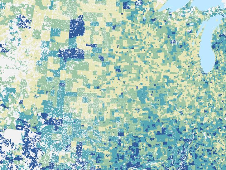
NASA's Socioeconomic Data and Applications Center released the U.S. Social Vulnerability Index Grids, facilitating integration with geospatial data.
News
Aug. 31, 2021

Data from NASA's Socioeconomic Data and Applications Center support researchers at the Center for International Earth Science Information Network.
News
Aug. 27, 2021

FIRMS has recently implemented a scalable user interface to better meet the needs and use cases of various users.
Blog
Aug. 24, 2021

View smoke in FIRMS using Corrected Reflectance Imagery or aerosol indices.
Blog
July 15, 2021

The dataset provides a picture of food insecurity over a 10-year period, in five global regions.
News
July 12, 2021

Image captured on 11 July 2021, by the VIIRS instrument, aboard the joint NASA/NOAA NOAA-20 satellite.
Worldview Image of the Week
July 12, 2021

The new FIRMS US/Canada fire map includes the location and details of wildland and prescribed fires.
Blog
July 9, 2021

Image captured on 21 June 2021, by the MODIS instrument, aboard the Aqua satellite.
Worldview Image of the Week
June 30, 2021
SHOWING 8 OF 534