We are in the process of migrating all NASA Earth science data sites into Earthdata from now until end of 2026. Not all NASA Earth science data and resources will appear here until then. Thank you for your patience as we make this transition.
Read about the Web Unification Project
Coastal Landforms Data Access and Tools
From discovery to visualization, data tools such as Earthdata Search, Worldview, and Giovanni guide users in making the most of coastal landform data.
Coastal Landforms Datasets
| Dataset | Version Sort ascending | Platforms | Instruments | Temporal Extent | Spatial Extent | Spatial Resolution | Data Format |
|---|---|---|---|---|---|---|---|
| SENTINEL-1B_DUAL_POL_METADATA_GRD_MEDIUM_RES | 1 | Sentinel-1B | C-SAR | 2016-04-25 to 2021-12-24 |
N: 90 S: -90 E: 180 W: -180 |
||
| Delta-X: Island and Secondary Channel Model, MRD, LA, USA, 2022 | 1 | COMPUTERS | Computer | 2021-01-01 to 2021-12-31 |
N: 55 S: -38 E: 140 W: -96 |
multiple | |
| ERS-2 Level 1 Product | 1 | ERS-2 | SAR | 1995-10-01 to 2011-07-04 |
N: 90 S: -90 E: 180 W: -180 |
||
| Pre-Delta-X: Total Suspended Solids of Surface Water across MRD, LA, USA, 2015-2016 | 1 | FIELD SURVEYS, LABORATORY | WATER BOTTLES, BALANCE | 2015-05-06 to 2016-10-21 |
N: 29.744 S: 29.2217 E: -90.6776 W: -91.5024 |
CSV | |
| SENTINEL-1A_METADATA_SLC | 1 | SENTINEL-1A | C-SAR | 2014-04-03 to Present |
N: 90 S: -90 E: 180 W: -180 |
||
| SENTINEL-1A_SINGLE_POL_GRD_HIGH_RES | 1 | SENTINEL-1A | C-SAR | 2014-04-03 to Present |
N: 90 S: -90 E: 180 W: -180 |
||
| SENTINEL-1B_METADATA_RAW | 1 | Sentinel-1B | C-SAR | 2016-04-25 to 2021-12-24 |
N: 90 S: -90 E: 180 W: -180 |
||
| Delta-X: NUMAR Predictive Model for Marsh Accretion Rates and Chemical Properties | 1 | COMPUTERS | Computer | 2020-01-01 to 2022-12-31 |
N: 29.76 S: 28.72 E: -90.19 W: -91.86 |
multiple | |
| JERS-1 Level 0 Product | 1 | JERS-1 | SAR | 1992-05-20 to 1998-10-11 |
N: 90 S: -90 E: 180 W: -180 |
||
| Pre-Delta-X: Vegetation Species, Structure, Aboveground Biomass, MRD, LA, USA, 2015 | 1 | FIELD SURVEYS | STEEL MEASURING TAPE, SURVEYING TOOLS | 2015-05-06 to 2015-09-28 |
N: 29.5395 S: 29.2471 E: -90.7278 W: -91.4591 |
CSV |
SHOWING 10 OF 65
Featured Coastal Landforms Observation Method: ICESat-2
NASA's Ice, Cloud, and Land Elevation Satellite-2 (ICESat-2) carries a photon-counting laser altimeter that allows scientists to measure the elevation of ice sheets, glaciers, sea ice, and more in unprecedented detail. Measuring elevation data along coastlines helps scientists learn more about coastal landforms.

This Satellite Needs Working Group solution provides reduced-latency versions of existing Ice, Cloud, and land Elevation Satellite-2 (ICESat-2) Advanced Topographic Laser Altimeter System (ATLAS) products.
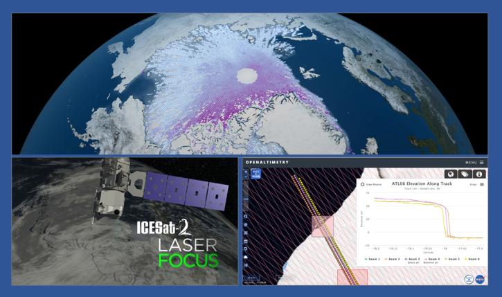
During this webinar we will introduce the ICESat-2 mission and show you how to explore, access and customize ICESat-2 data with the advanced discovery and visualization OpenAltimetry application, directly filter and access ICESat-2 data from an NSIDC DAAC data set page and subset, reformat and analyze ICESat-2 data using Python-based resources.

This is the first in a five-part webinar series to introduce NASA's Ice, Cloud, and land Elevation-2 (ICESat-2) platform and the platform's data, tools, and applications.

This ACCESS 2015 project focused on OpenAltimetry, a cloud-ready web-based application for discovery, access, and visualization of ICESat and ICESat-2 data.
Coastal Landforms Data Tools
| Tool Sort descending | Description | Services | |
|---|---|---|---|
| OB.DAAC File Search Utility | Find and download instrument data archived at OB.DAAC using mission parameters or filename patterns, including support for wildcard searching on partial filenames. | Analysis, Search and Discovery, Visualization |
SHOWING 1 OF 1
Frequently Asked Questions
Earthdata Forum
Our online forum provides a space for users to browse thousands of FAQs about research needs, data, and data applications. You can also submit new questions for our experts to answer.
Submit Questions to Earthdata Forumand View Expert Responses