Earth’s land surface interacts with thermal energy from sunlight in a variety of ways. Some terrain types readily absorb and retain heat, while others diffuse heat quickly. Factors that determine land surface thermal properties include how much sunlight the land reflects back into space, the presence or absence of vegetation, and the land's water or ice content.

The thermal properties of an area of land can greatly affect ecosystems and agriculture. Decision makers often take heat exchange with land into account when creating water irrigation strategies, managing crop health and water stress, and reducing heat island effects in urban areas. 

NASA’s Earth-observing satellites collect data on several factors that help researchers model surface thermal properties, such as land surface temperature, soil moisture, and albedo. These data products help scientists better understand Earth’s energy cycle and enable studies into weather, agriculture production, and ecosystem health.

Get Surface Thermal Properties Data

Access a range of datasets and data tools to further your research into surface thermal properties.

Learn How to Use Surface Thermal Properties Data

Access a range of webinars, tutorials, data recipes, and data stories to enhance your knowledge of Earth Observation data.
image of binary code over satellite color data
Convert LANCE NRT AMSR2 Land Data to GeoTIFF Format Using Python
This code converts the soil moisture ('SoilMoistureNPD') parameter in the Advanced Microwave Scanning Radiometer 2 (AMSR2) Near Real Time (NRT) Land product in HDF-EOS5 format to GeoTIFF.
Earthdata graphic identifier on top of satellite data image of Earth
Land Ho! Exploring Earth's Land Surface with Suomi NPP NASA VIIRS Land Data
Looking to learn more about Suomi NPP VIIRS global land data products available from NASA? Join us for an overview of the data products and live demos on how to access and work with the data using a variety of tools from the Land Processes DAAC.
A Terra MODIS nighttime LST composite of the Po Valley, the research area of the Zullo and others (2019) study
Vegetation Trends, Urban Growth and Land Surface Temperature, and Geothermal Activity
Explore how NASA data helps track NDVI trends in Spain, analyze rising land surface temperatures in Italy, and detect geothermal anomalies in Turkey using MODIS and ASTER imagery.
A view of the study area from Hain and Anderson (2017) is shown in this MODIS Daily Land Surface Temperature image
Measuring Land Temperature Change, Aboveground Biomass, and Reservoir Water Extent
Read highlights of three publications that detail how NASA Earth observation data informs measurement of surface temperature and energy balance, biomass, and reservoir water extent.
Discover and Visualize Surface Thermal Properties Data
NASA data help us understand Earth's changing systems in more detail than ever before, and visualizations bring these data to life, making Earth science concepts accessible, beautiful, and impactful.
Data visualization is a powerful tool for analysis, trend and pattern recognition, and communication. Our resources help you find world-class data visualizations to complement and enhance your research. We also have tools and tutorials to help you translate surface thermal properties data into compelling visuals.
Image
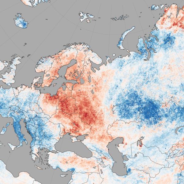
Map of Europe showing temperature anomalies in the summer of 2014 collected by MODIS.
This map shows land surface temperature anomalies for July 27–August 3, 2014, based on data collected by the Moderate Resolution Imaging Spectroradiometer (MODIS) on NASA’s Terra satellite. The darkest reds show areas that were as much as 10°C (20°F) above the norm compared to the same period between 2005-2013, and blues show areas that were below normal.

Join Our Community of NASA Data Users

While NASA data are openly available without restriction, an Earthdata Login is required to download data and to use some tools with full functionality.

Learn About the Benefits of Earthdata Login

Frequently Asked Questions

Earthdata Forum

Our online forum provides a space for users to browse thousands of FAQs about research needs, data, and data applications. You can also submit new questions for our experts to answer.

Submit Questions to Earthdata Forumand View Expert Responses
Earthdata
Forum