We are in the process of migrating all NASA Earth science data sites into Earthdata from now until end of 2026. Not all NASA Earth science data and resources will appear here until then. Thank you for your patience as we make this transition.
Read about the Web Unification Project
Solid Earth News
Articles, resources, and announcements from Solid Earth.

Who Uses NASA Earth Science Data? Rowena Lohman, to study earthquake physics, satellite remote sensing, finite element modeling, ground displacements from a variety of anthropogenic and natural causes.
Data User Story
April 22, 2021

Dr. Bernard Hubbard uses NASA Earth science data to help locate mineral resources and assess natural hazards.
Data User Story
April 22, 2021

Who uses NASA Earth science data? Dr. Erricos C. Pavlis, to help accurately measure Earth.
Data User Story
April 22, 2021
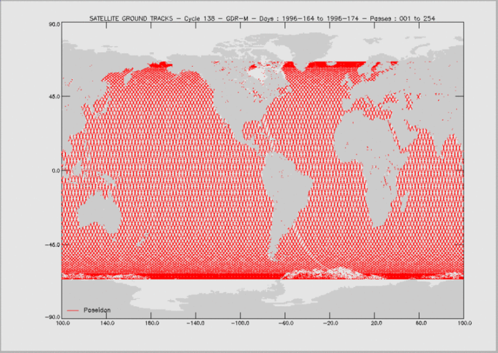
Knowing the precise location of a satellite in space is critical for determining sea surface height and, through this, the rate of global mean sea level rise.
Feature Article
April 19, 2021

50 years ago this October, the first successful Satellite Laser Range measurements were taken, ushering in a new era in the science of measuring the Earth’s exact shape, center of gravity, and precise rotation.
Feature Article
April 15, 2021

The Global Sea Level Change portal is NASA’s home for sea level change data and information. As the portal’s principal investigator, Dr. Boening ensures that it remains a key resource for both scientists and the general public.
Data User Story
April 12, 2021
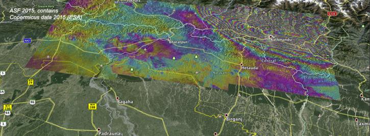
Ground deformation caused by the April 25 Nepal earthquake is clearly visible in this new interferogram processed from Sentinel-1A data by ASF DAAC scientists Franz Meyer and Wenyu Gong.
News
March 30, 2021

The Global Navigation Satellite System (GNSS) enables the precise location of points on Earth’s surface. For geodesists like Dr. Herring, it also is a key geodetic technique for his studies of surface deformation processes.
Data User Story
Jan. 7, 2021
SHOWING 8 OF 48