We are in the process of migrating all NASA Earth science data sites into Earthdata from now until end of 2026. Not all NASA Earth science data and resources will appear here until then. Thank you for your patience as we make this transition.
Read about the Web Unification Project
Tectonics Data Access and Tools
Tectonics Datasets
| Dataset Sort descending | Version | Platforms | Instruments | Temporal Extent | Spatial Extent | Spatial Resolution | Data Format |
|---|---|---|---|---|---|---|---|
| NISAR Beta Geocoded Polarimetric Covariance Product (Version 1) | 1 | NISAR | L-SAR, S-SAR | 2025-10-01 to Present |
N: 90 S: -90 E: 180 W: -180 |
HDF5, PNG, XML, PDF, CSV, KML, YAML | |
| NISAR Beta Geocoded Single Look Complex Product (Version 1) | 1 | NISAR | L-SAR, S-SAR | 2025-10-01 to Present |
N: 90 S: -90 E: 180 W: -180 |
HDF5, PNG, XML, PDF, CSV, KML, YAML | |
| NISAR Beta Geocoded Unwrapped Interferogram Product (Version 1) | 1 | NISAR | L-SAR, S-SAR | 2025-10-01 to Present |
N: 90 S: -90 E: 180 W: -180 |
HDF5, PNG, XML, PDF, CSV, KML, YAML | |
| NISAR Beta Range Doppler Pixel Offsets (Version 1) | 1 | NISAR | L-SAR, S-SAR | 2025-10-01 to Present |
N: 90 S: -90 E: 180 W: -180 |
HDF5, XML, YAML, PNG, KML, CSV, PDF | |
| NISAR Beta Range Doppler Single Look Complex Product (Version 1) | 1 | NISAR | L-SAR, S-SAR | 2025-10-01 to Present |
N: 90 S: -90 E: 180 W: -180 |
HDF5, XML, PNG, PDF, CSV, KML, YAML | |
| NISAR Beta Range Doppler Unwrapped Interferogram Product (Version 1) | 1 | NISAR | L-SAR, S-SAR | 2025-10-01 to Present |
N: 90 S: -90 E: 180 W: -180 |
HDF5, XML, YAML, PNG, KML, CSV, PDF | |
| NISAR Beta Range Doppler Wrapped Interferogram Product (Version 1) | 1 | NISAR | L-SAR, S-SAR | 2025-10-01 to Present |
N: 90 S: -90 E: 180 W: -180 |
HDF5, XML, YAML, PNG, KML, CSV, PDF | |
| OPERA Coregistered Single-Look Complex from Sentinel-1 Static Layers validated product (Version 1) | 1 | Sentinel-1A, Sentinel-1B | C-SAR | 2014-04-03 to Present | HDF5, XML | ||
| OPERA Coregistered Single-Look Complex from Sentinel-1 validated product (Version 1) | 1 | Sentinel-1A, Sentinel-1B, Sentinel-1C | C-SAR | 2016-07-01 to Present | HDF5, XML | ||
| OPERA Radiometric Terrain Corrected SAR Backscatter from Sentinel-1 Static Layers validated product (Version 1) | 1 | Sentinel-1A, Sentinel-1B | C-SAR | 2014-04-03 to Present |
N: 90 S: -90 E: 180 W: -180 |
GeoTIFF, XML |
SHOWING 10 OF 266
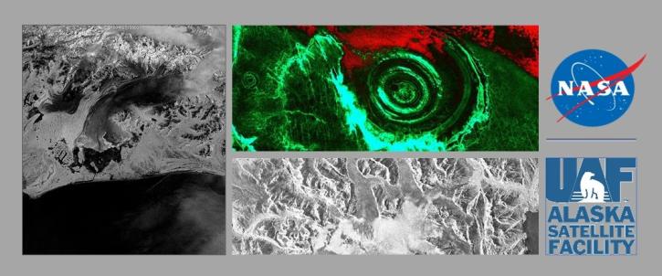
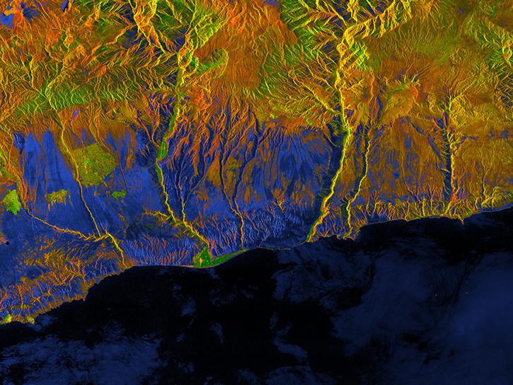
Featured Tectonics Observation Method: Sentinel-1 C-band Synthetic Aperture Radar
The ESA (European Space Agency's) Sentinel-1A/B satellites are equipped with synthetic aperture radar (SAR) instruments that record continuous all-weather, day-and-night imagery. SAR energy beams can penetrate cloud and tree canopy cover to detect very small changes to the height, shape, and position of Earth surfaces. The ability of Sentinel-1 to capture detailed SAR images anywhere at any time makes them excellent tools for producing interferograms and digital elevation models to track the movement of Earth's plates.

Join us as we show new and experienced users how to use Vertex to discover and access Sentinel-1 synthetic aperture radar (SAR) data at NASA's Alaska Satellite Facility (ASF) Distributed Active Archive Center (DAAC).
NASA's ASF DAAC has rolled out the first tool in its planned Advanced Products Toolbox for synthetic aperture radar (SAR) data with a single-command Radiometrically Terrain-Correct (RTC) tool. Join us for the tool demo and provide your input.
This webinar will introduce users to radiometrically terrain corrected (RTC) datasets and demonstrate the process of using Vertex to search for source granules, submit them for processing, and access the finished products.

NASA's ASF DAAC released the Global Seasonal Sentinel-1 Interferometric Coherence and Backscatter Dataset.
Tectonics Data Tools
| Tool Sort descending | Description | Services | |
|---|---|---|---|
| GUARDIAN | The GNSS-based Upper Atmospheric Realtime Disaster Information and Alert Network (GUARDIAN) is a near real-time (NRT) ionospheric monitoring tool for natural hazards warning. | Monitoring Natural Events |
SHOWING 1 OF 1
Frequently Asked Questions
Earthdata Forum
Our online forum provides a space for users to browse thousands of FAQs about research needs, data, and data applications. You can also submit new questions for our experts to answer.
Submit Questions to Earthdata Forumand View Expert Responses