We are in the process of migrating all NASA Earth science data sites into Earthdata from now until end of 2026. Not all NASA Earth science data and resources will appear here until then. Thank you for your patience as we make this transition.
Read about the Web Unification Project
Suomi NPP Resources
Suomi NPP Learning Resources

This training covers the theoretical approaches and key datasets to estimate historical PM2.5 from satellite aerosol optical depth.
Training
July 8-22, 2026

This ARSET training introduces participants to several capabilities within FIRMS that were not included in the previous ARSET training.
Training
Jan. 14-21, 2026

Agricultural burning in Kansas produces smoky skies and healthy crops.
Data in Action
June 6, 2025

A comparison of aurora forecasts with actual satellite observations suggests VIIRS DNB data can enhance space weather prediction efforts.
Data in Action
May 30, 2025

Our Earth Data Officer, Katie Baynes, spoke at the Federal GIS Conference Plenary. In case you missed her presentation, here is a story map for you to catch up on how NASA Earth data can be leveraged in your GIS project.
StoryMap
March 5, 2025

Join us to learn more about datasets and tools that enable the harmonization of remote sensing and in situ ecological data products for site-based research.
Webinar
Aug. 22, 2024

Due to unforeseen circumstances, this webinar is postponed and will be rescheduled soon. We apologize for the short notice and appreciate your continued interest and support. We look forward to your attendance at our rescheduled webinar, to be announced.
Webinar
June 26, 2024

This webinar introduces the Geostationary Earth Orbit (GEO)-Low-Earth Orbit (LEO) Dark Target Aerosol data product suite and shows how to find, access, and download the data.
Webinar
May 16, 2024
SHOWING 8 OF 67
Suomi NPP News
View All News
Filters

Image captured on 17 October 2021, by the VIIRS instrument, aboard the joint NASA/NOAA Suomi NPP satellite.
Worldview Image of the Week
Dec. 21, 2021

NASA’s Land, Atmosphere Near real-time Capability for EOS (LANCE) helps scientists like Dr. Glasscoe assess risks and responses to natural hazards on a global scale.
Data User Story
Dec. 8, 2021

Base image captured on Oct. 25, 2021, by the VIIRS instrument aboard the joint NASA/NOAA Suomi NPP satellite and overlain with IMERG Precipitation Rate.
Worldview Image of the Week
Dec. 7, 2021
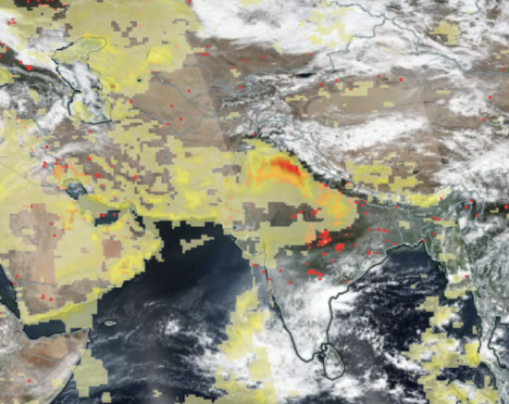
Image captured Nov 1, 2021, by the VIIRS instrument aboard the joint NASA/NOAA Suomi NPP satellite.
Worldview Image of the Week
Dec. 7, 2021
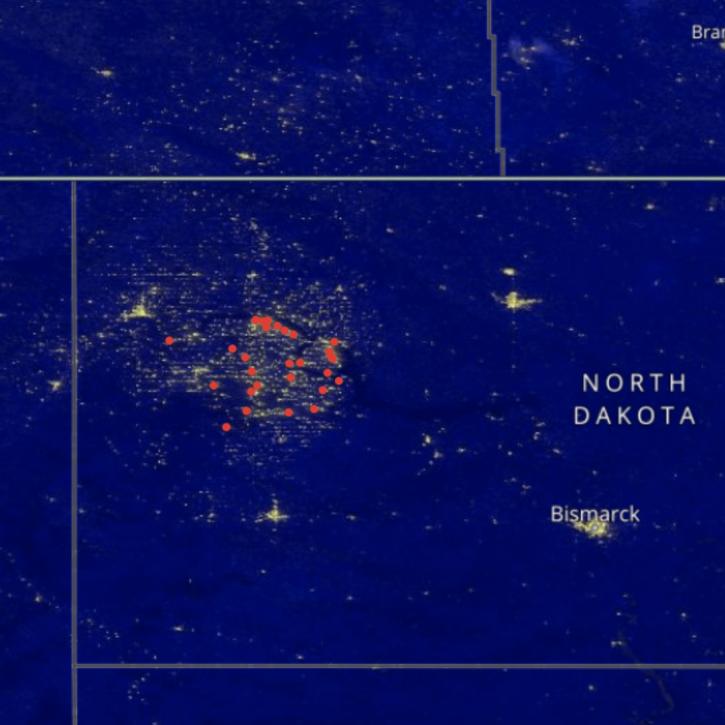
Image captured on Sep 27, 2021, by the VIIRS instrument aboard the joint NASA/NOAA Suomi NPP satellite.
Worldview Image of the Week
Oct. 29, 2021
Data from NASA’s GES DISC helps scientists like Dr. Nadia Smith build and improve retrieval systems that provide important information to climate scientists and meteorologists around the globe.
Data User Story
Oct. 25, 2021

Satellites provide crucial information for researchers to monitor and help improve agricultural productivity in India.
Feature Article
Oct. 22, 2021

Image captured on Aug 22, 2021, by the VIIRS instrument, aboard the joint NASA/NOAA NOAA 20 satellite.
Worldview Image of the Week
Oct. 22, 2021
SHOWING 8 OF 333
Frequently Asked Questions
Earthdata Forum
Our online forum provides a space for users to browse thousands of FAQs about research needs, data, and data applications. You can also submit new questions for our experts to answer.
Submit Questions to Earthdata Forumand View Expert Responses