We are in the process of migrating all NASA Earth science data sites into Earthdata from now until end of 2026. Not all NASA Earth science data and resources will appear here until then. Thank you for your patience as we make this transition.
Read about the Web Unification Project
Filters

Join us on Wed., Nov. 19, 2025, at 2 p.m. EST for the fifth NASA ICESat-2 data training webinar. Participants will learn about ICESat-2 inland surface water data, services, and tools.
Webinar
Nov. 13, 2025
The addition of HLS data to Azure provides a foundation for next-generation Earth observation capabilities.
Blog
Sept. 30, 2025
NASA's AIRS instrument provides information about precipitable water vapor, a key variable in determining the potential strength of hurricanes and tropical cyclones.
Blog
Sept. 30, 2025
Learn how to use AIRS soundings to determine the amount of precipitable water vapor in the atmosphere and predict whether a storm will increase in intensity.
Tutorial
Sept. 30, 2025

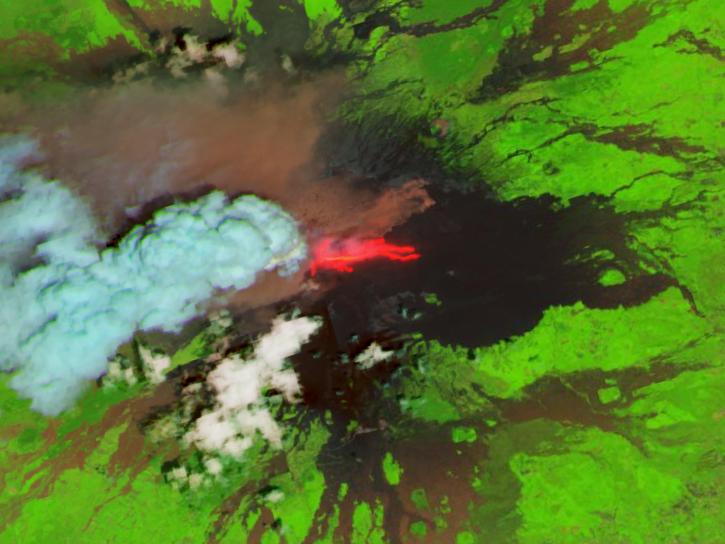
Image captured September 24, 2025, by the VIIRS instrument aboard the joint NASA/NOAA NOAA-21 platform.
Worldview Image of the Week
Sept. 25, 2025

Using machine learning models, researchers identify high ECOSTRESS Water Use Efficiency ratios as the most influential pre-fire factor.
News
Sept. 25, 2025
Learn how ECOSTRESS data may significantly improve wildfire prediction by capturing drought signals that precede wildland fire events.
Data in Action
Sept. 25, 2025

The VIIRS product provides continuity to the MODIS-generated NASA standard science burned area product.
Blog
Sept. 24, 2025
SHOWING 8 OF 2371