Earth Science Data Roundup: June 2025

A summary of datasets, products, and resources released by NASA’s Distributed Active Archive Centers (DAACs) in May 2025.

Alaska Satellite Facility Distributed Active Archive Center (ASF DAAC)

OPERA Level 3 Surface Displacement Products Released

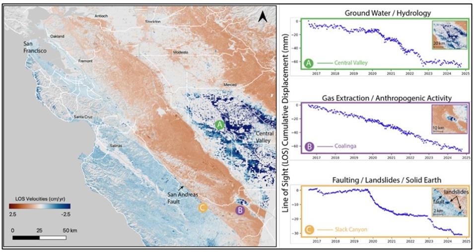
NASA’s ASF DAAC released the Level-3 Sentinel-1 Surface Displacement (DISP) product from the Observational Products for End-Users from Remote Sensing Analysis (OPERA) project at NASA’s Jet Propulsion Laboratory (JPL). This product, which is generated through interferometric time-series analysis of Level-2 Coregistered Sentinel-1 Single Look Complex (CSLC) data, enables the detection of anthropogenic and natural surface changes, including subsidence, tectonic deformation, and landslides.

The product provides spatial coverage across North America, encompassing the United States, U.S. territories within 200 kilometers of the U.S. border, Canada, and mainland countries from the southern U.S. border to Panama. The temporal coverage of the product begins in mid-2016 and data are available in HDF-5 format. 

Access the OPERA Level 3 Displacement Data and more information.

For more information about the OPERA Level 3 displacement product suite, see this dataset announcement. For more in-depth information about the product and how to view it in the ASF DAAC’s Displacement Portal, see the “Discover and Access the OPERA-DISP Dataset Using ASF DAAC’s Displacement Portal” webinar that was recorded on May 29.

Image
Image Caption

This visualization of OPERA Sentinel-1-based Surface Displacement (DISP-S1) data shows the line-of-sight time series history of land motion (in centimeters per year) due to A) groundwater pumping, B) gas extraction, and C) landslides in California from 2017 through mid-2024. Credit: OPERA Project/NASA JPL

Atmospheric Science Data Center (ASDC)

PREFIRE Satellite 2 Cloud Mask R01 Dataset Released

NASA's ASDC released the Polar Radiant Energy in the Far InfraRed Experiment (PREFIRE) Satellite 2 Cloud Mask R01 dataset (PREFIRE_SAT2_2B-MSK), which contains a binary clear/cloud indicator and probabilities derived from data collected by the PREFIRE Thermal Infrared Spectrometer (TIRS-PREFIRE) aboard the PREFIRE-SAT2.

The PREFIRE_SAT2_2B-MSK product is used to identify cloudy and clear scenes in TIRS-PREFIRE data, which supports the production of other Level 2 PREFIRE products. These include variables such as top of atmosphere spectral flux, surface spectral emissivity, and atmospheric properties such as temperature and water vapor profiles. Science data retrieval started June 29, 2024, and is ongoing. Geographic coverage is global, with the greatest concentration of data in the polar regions. The data are available in netCDF-4 format.

Access the PREFIRE Cloud Mask R01 dataset and more information.

Image
Image Caption

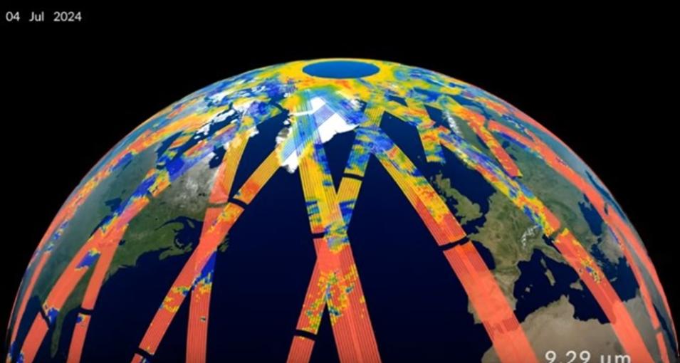
This still frame from a PREFIRE first light video shows a visualization of PREFIRE-SAT2 data captured in July 2024. The colored strips are the brightness temperatures (a measure of the intensity of infrared emissions) measured along the CubeSat's orbit swaths. Red indicates intense infrared emissions from Earth, while blue/purple indicates less-intense infrared emissions. Credit: NASA’s Scientific Visualization Studio

Land Processes Distributed Active Archive Center (LP DAAC)

ASTER Version 4 Data Product Suite Released

NASA's LP DAAC released the Advanced Spaceborne Thermal Emission and Reflection Radiometer (ASTER) Version 4 product suite. This suite of data products provides high-resolution multispectral data from the ASTER instrument aboard NASA’s Terra satellite, covering 14 spectral bands from visible to thermal infrared with spatial resolutions of 15 meters visible and near infrared (VNIR), 30 meters short-wave infrared (SWIR), and 90 meters thermal infrared (TIR). These products are used in applications such as geological mapping, vegetation analysis, and climate monitoring.

The products included in this suite are:

  • ASTER L1A Reconstructed Unprocessed Instrument Data V004- AST_L1A.004
  • ASTER L1B Registered Radiance at the Sensor V004- AST_L1B.004
  • ASTER Level 1 Precision Terrain Corrected Registered At-Sensor Radiance V004- AST_L1T.004
  • ASTER L2 Surface Emissivity V004- AST_05.004
  • ASTER L2 Surface Reflectance VNIR and SWIR V004- AST_07.004
  • ASTER L2 Surface Reflectance VNIR and Crosstalk Corrected SWIR V004- AST_07XT.004
  • ASTER L2 Surface Kinetic Temperature V004- AST_08.004
  • ASTER L2 Surface Radiance VNIR and SWIR V004- AST_09.004
  • ASTER L2 Surface Radiance TIR V004- AST_09T.004
  • ASTER L2 Surface Radiance VNIR and Crosstalk Corrected SWIR V004- AST_09XT.004
  • ASTER Digital Elevation Model V004- AST14DEM.004

The Version 4 suite includes 11 selected products, such as precision terrain-corrected radiance, surface reflectance, and emissivity, forming a static collection that spans the full ASTER mission period.

This initial release covers the beginning of the ASTER mission from March 2000 through 2003 and will continue to be updated chronologically as the processing continues. Upon completion of this final processing campaign, users will be directed to access the static Version 4 collections for all ASTER data needs, as on-demand products will not be offered for Version 4.

Access the ASTER Version 4 Data Product Suite and more information.

Image
Image Caption

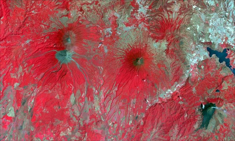
This image shows Terra ASTER reconstructed unprocessed instrument band combination 3n-2-1 data from the AST_Level 1 product over Guatemala on March 23, 2003. Credit: LP DAAC

VIIRS Version 2 BRDF/Albedo Model Parameter Data Products Now Available

LP DAAC released the Visible Infrared Imaging Radiometer Suite (VIIRS) Version 2 Bidirectional Reflectance Distribution Function (BRDF)/ Albedo model parameter product suite. Version 2 includes data products from the Suomi National Polar-orbiting Partnership (Suomi NPP) and NOAA-20 satellites. A total of 178 products are included in this release. Due to the large file size, each Suomi NPP and NOAA-20 product contains just one data layer. Both product suites are provided in a Climate Modeling Grid (CMG), which covers the entire globe for use in climate simulation models. 

A list of all products available in these suites can be found on the LP DAAC website.

Access the VIIRS Version 2 BRDF/Albedo Model Parameter Data Products and more information.

EMIT Methane and Carbon Dioxide Enhancement Version 2 Data Products Released

LP DAAC released the Earth Surface Mineral Dust Source Investigation (EMIT) Level 2B Methane Enhancement Data (EMITL2BCH4ENH) and Level 2B Carbon Dioxide Enhancement Data (EMITL2BCO2ENH) Version 2 data products at a 60 meter (m) spatial resolution. 

These Version 2 data products provide methane and carbon dioxide enhancement, uncertainty, and sensitivity data in Cloud Optimized GeoTIFF (COG) format for all granules regardless of plume complex detection within the granule. Version 1 data products only provide granules where plume complexes were identified. 

Access the EMIT Methane and Carbon Dioxide Enhancement Version 2 data products and more information.

Image
Image Caption

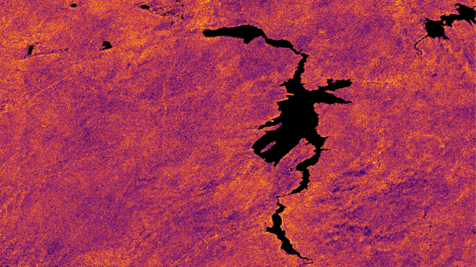
This image shows carbon dioxide enhancement data from the EMITL2BCO2ENH version 2 data product over Pathfinder Reservoir, Wyoming, on April 14, 2025. Credit: LP DAAC

OPERA Disturbance Alert Version 0 Provisional Data Decommissioned

LP DAAC announced that, as of April 24, 2025, the Observational Products for End-Users from Remote Sensing Analysis (OPERA) project’s Land Surface Disturbance Alert from Harmonized Landsat Sentinel-2 provisional (OPERA_L3_DIST-ALERT-HLS) Version 0 data product is no longer available through Earthdata Search. 

Users are encouraged to transition to the OPERA_L3_DIST-ALERT-HLS Version 1 data product, which was released on March 14, 2024, and has achieved Stage 1 validation. Users currently working with Version 0 data are advised to migrate their workflows to the Version 1 product to ensure continuity and access to the most accurate and up-to-date information.

Learn more about the decommissioning of the OPERA_L3_DIST-ALERT-HLS Version 1 data product.

ECOSTRESS Version 1 Radiance, Cloud Mask, and Land Surface Temperature and Emissivity Data Products Decommissioned 

LP DAAC announced that, as of May 30, 2025, the following products from ECOsystem Spaceborne Thermal Radiometer Experiment on Space Station (ECOSTRESS) mission are longer be available through the Earthdata Search. 

  • ECOSTRESS At-sensor Calibrated Radiance Daily L1B Global 70 m Version 1 (ECO1BRAD)
  • ECOSTRESS Cloud Mask Daily L2 Global 70 m Version 1 (ECO2CLD)
  • ECOSTRESS Land Surface Temperature and Emissivity Daily L2 Global 70 m Version 1 (ECO2LSTE

In addition, ECO2CLD and ECO2LSTE will no longer be available through AppEEARS as of that same date.

Users are encouraged to transition to the ECOSTRESS Swath Top of Atmosphere Calibrated Radiance Instantaneous Level 1B Global 70 meter Version 2 (ECO_L1B_RAD), ECOSTRESS Swath Cloud Mask Instantaneous Level 2 Global 70 meter Version 2 (ECO_L2_CLOUD), and ECOSTRESS Swath Land Surface Temperature and Emissivity Instantaneous Level 2 Global 70 meter Version 2 (ECO_L2_LSTE) data products. Gridded and tiled versions are also offered for these products. Users working with ECOSTRESS Version 1 data are encouraged to migrate their workflows to the Version 2 data products as historical processing is being completed.

Learn more about the decommissioning of these ECOSTRESS products.

National Snow and Ice Data Center Distributed Active Archive Center (NSIDC DAAC)

Bootstrap Sea Ice Concentrations from Nimbus-7 SMMR and DMSP SSM/I-SSMIS, Version 4 dataset Updated

NASA’s NSIDC DAAC updated the Bootstrap Sea Ice Concentrations from Nimbus-7 Scanning Multichannel Microwave Radiometer (SMMR) and Defense Meteorological Satellite Program (DMSP) Special Sensor Microwave Imager (SSM/I)-Special Sensor Microwave Imager/Sounder (SSMIS), Version 4 dataset. The dataset, which now includes new data through December 31, 2024, consists of daily and monthly sea ice concentrations derived from brightness temperature measurements. Data are available for the north and south polar regions, with a temporal coverage extending back to November 1, 1978. The data are gridded to the 25 kilometer polar stereographic projection and provided in two-byte integer format.

Access Sea Ice Concentration data and more information.
Image
Image Caption

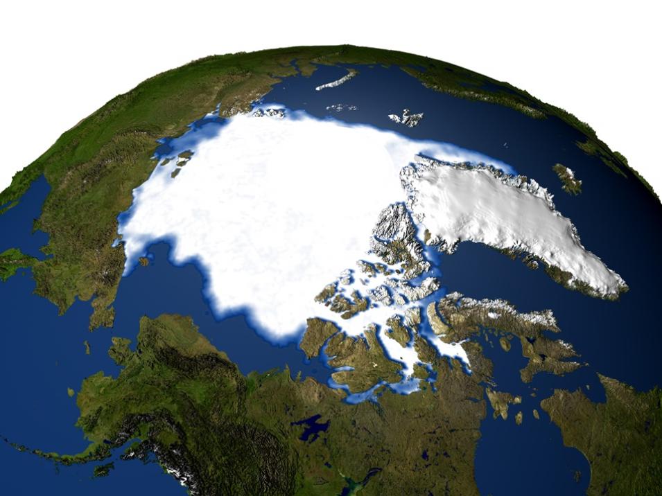
This composite image shows minimum sea ice concentrations over the Arctic Circle for the year 1979 acquired by the DMSP Special Sensor Microwave Imager (SSMI). Credit: NASA GSFC Scientific Visualization Studio

Operation IceBridge Portal and IceFlow NSIDC Data Tutorial Notebooks to be Retired

NSIDC DAAC announced that the Operation IceBridge Portal and IceFlow NSIDC Data Tutorial Notebooks will be retired by June 30, 2025, as part of NSIDC DAAC's transition to NASA’s Earthdata Cloud. These tools rely on underlying components that will be decommissioned during this transition. Access to both tools became limited on June 11, 2025.

Guidance on each tool’s retirement process, as well as alternative data search, access, and transformation options, is available on the NSIDC website.

Several Datasets in NSIDC DAAC's Legacy, On-Premises Archive to be Retired

NSIDC DAAC announced that several datasets in its legacy, on-premises archive will be retired in the coming months. These datasets include: 

The NASA Earthdata Cloud is now the primary data archive for these data. Users who currently access data through the legacy, on-premises archive, including through the HTTPS File System or through the Earthdata Search Stage for Delivery (ECHO Orders) option, are advised to update their data access workflows and scripts to use the Earthdata Cloud archive. 

For more information, follow the links associated with the datasets mentioned above.

SnowEx23 Corner Reflector Location and Orientation, Version 1 Dataset Available

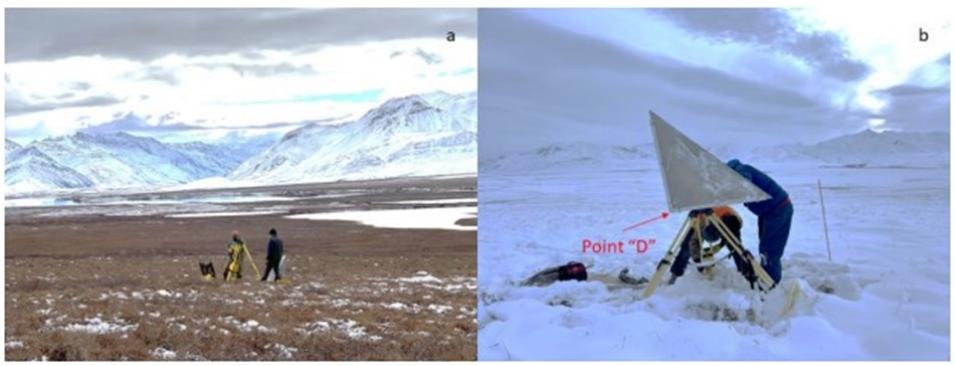
The SnowEx23 Corner Reflector Location and Orientation, Version 1 dataset, which contains an inventory of corner reflectors installed in northern Alaska, is now available from NSIDC DAAC. Temporal coverage spans from September 21, 2022, to November 30, 2023.

Access the SnowEx23 Corner Reflector Location and Orientation, Version 1 Dataset, and more information.

Image
Image Caption

These images show researchers installing 36-in trihedral corner reflectors in Northern Alaska, USA, as part of the NASA SnowEx 2023 field campaign on September 21, 2022 (a) on October 17, 2023 (b). Credit: NSIDC

NASA Earthdata Cloud Access option for MEaSUREs collection Now Available

NSIDC DAAC added 42 datasets from the Making Earth System Data Records for Use in Research Environments (MEaSUREs) collection to NASA Earthdata Cloud on May 27, 2025. These datasets will be available via their current URLs and workflows until June 26, 2025. After that date, the legacy HTTPS File System URL and Earthdata Search Stage for Delivery (ECHO Orders) will no longer be available. Users are encouraged to update their direct download workflows and scripts to use the new Earthdata Cloud access URLs. The Earthdata Cloud HTTPS data access URL will be available from each dataset landing page using the HTTPS File System link under Data Access and Tools after the publication date.

The NSIDC DAAC User Services Office provides support for direct data download from Earthdata Cloud HTTPS and basic access to our AWS Simple Storage Service (S3) buckets. See the Earthdata Cloud Access Guide for more details on these access options. 

Visit the NSIDC DAAC website for more information. For a complete listing of datasets, visit the MEaSUREs data page.

Sea Ice Concentrations from Nimbus-7 SMMR and DMSP SSM/I-SSMIS Passive Microwave Data, Version 2 Dataset Updated

NSIDC DAAC updated the Sea Ice Concentrations from the Nimbus-7 Scanning Multichannel Microwave Radiometer (SMMR) Defense Meteorology Satellite Program's Special Sensor Microwave Imager (SSM/I)-Special Sensor Microwave Imager/Sounder (SSMIS) Passive Microwave Data, Version 2 dataset through December 31, 2024. This dataset is generated from brightness temperature data and is designed to provide a consistent time series of sea ice concentrations spanning the coverage of several passive microwave instruments. The data are provided in the polar stereographic projection at a grid cell size of 25 x 25 kilometers.

Access the Sea Ice Concentrations from Nimbus-7 SMMR and DMSP SSM/I-SSMIS Passive Microwave Data, Version 2 Dataset, and more information.

SnowEx20 APL-UW CASIE Brightness Temperatures, Thermal Infrared Imagery (TIR), and Visible-Band Imagery (RGB), Version 1 Dataset Available

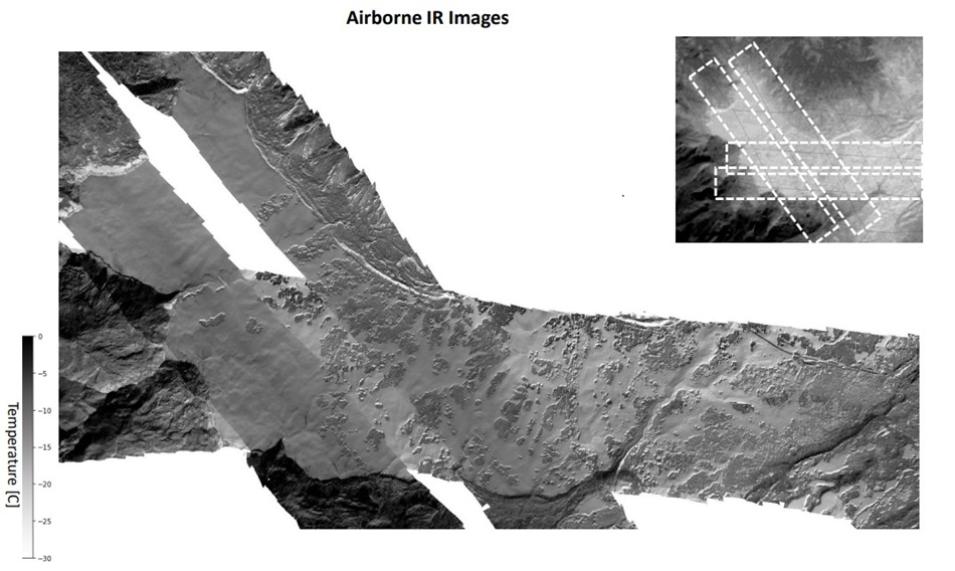
The SnowEx20 APL-UW Compact Airborne System for Imaging the Environment (CASIE) Brightness Temperatures, Thermal Infrared Imagery (TIR), and Visible-Band Imagery (RGB), Version 1 dataset is now available from NSIDC DAAC. This dataset contains long-wave infrared radiometer data, thermal infrared imagery, and visible-band imagery from the February 2020 NASA SnowEx field campaign flights over the Grand Mesa, Colorado. The measurements document the snow, forest, and land surface temperatures over targeted points of the mesa coincident with ground survey stations. Temporal coverage spans from February 8-12, 2020.

Access the SnowEx20 APL-UW CASIE Brightness Temperatures, Thermal Infrared Imagery (TIR), and Visible-Band Imagery (RGB), Version 1 Dataset and more information.

Image
Image Caption

During the SnowEx20 field campaign at Grand Mesa, Colorado, researchers sought to capture the spatial variabilities of surface temperature and how temperatures changed over time. Therefore, the UW-APL thermal Infrared imager was flown over the study area several times during  the field campaign (see inset). This image shows temperature data from one of those flights. Credit: Chris Chickadel, University of Washington

Select Northern Hemisphere Glacier Velocity Maps Using Customized autoRIFT and PlanetScope Imagery, Version 1 Dataset Released

The Select Northern Hemisphere Glacier Velocity Maps Using Customized autoRIFT and PlanetScope Imagery, Version 1 dataset is now available from NSIDC DAAC. This dataset consists of velocity maps and error estimates for five surge-type glaciers across the northern hemisphere. The maps are generated from a time series of satellite images using CautoRIFT, an augmented version of NASA's autonomous Repeat Image Feature Tracking (autoRIFT) algorithm for Sentinel-2 and Landsat imagery that improves temporal coverage during periods of rapid glacier motion by incorporating pre-processed, daily high-resolution PlanetScope (PS) images and customized feature tracking parameters for each glacier.

Access the Select Northern Hemisphere Glacier Velocity Maps Using Customized autoRIFT and PlanetScope Imagery data and more information.

Oak Ridge National Laboratory Distributed Active Archive Center (ORNL DAAC)

BioSCape: AVIRIS-NG L3 Resampled Reflectance Mosaics, Version 2 Dataset Released 

NASA's ORNL DAAC released the BioSCape Airborne Visible / Infrared Imaging Spectrometer-Next Generation (AVIRIS-NG) Level 3 Resampled Reflectance Mosaics, Version 2 Dataset.

This dataset provides mosaics of resampled surface reflectance from the AVIRIS-NG instrument used during the Biodiversity Survey of the Cape (BioSCape) project, a multi-agency, NASA-led research project that integrates airborne imaging spectroscopy and lidar with a suite of measurements of biodiversity.

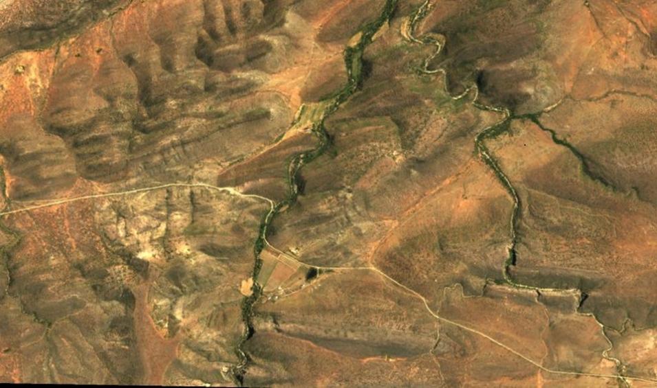
The AVIRIS-NG imagery was acquired in October-November 2023 over South Africa's Greater Cape Floristic Region. Level 2B surface reflectance data from these AVIRIS-NG collections were resampled to 5-meter spatial resolution and mosaiced into a regular tile system of 807 tiles. A given tile includes multiple AVIRIS-NG scenes from several flight lines spanning multiple days. The dataset also includes surface reflectance with uncertainty for each tile in netCDF format, along with a RGB quicklook image in TIFF format. A spatial index of mosaic grid ties is also included in GeoJSON format.

Access the BioSCape: AVIRIS-NG L3 Resampled Reflectance Mosaics, Version 2 Dataset, and more information.

Image
Image Caption

This image shows a portion of a quick-look image (tile 28_53) from the BioSCape Airborne Visible / Infrared Imaging Spectrometer-Next Generation Level 3 Resampled Reflectance Mosaics dataset over the Lopende River region in Western Cape, South Africa. Source: ORNL DAAC

Physical Oceanography Distributed Active Archive Center (PO.DAAC)

SWOT Science Data Products Transition from Version C to Version D complete

NASA's PO.DAAC announced that the Surface Water and Ocean Topography (SWOT) Science Data Products Transition from Version C to Version D is now complete. This means that Ka-band Radar Interferometer (KaRIn) Version D products distributed by PO.DAAC are available in the following collections:

Data ProductDescription
Level 1B Low-Rate Interferogram Data Product, doi:10.5067/SWOT-INTF-D

This product provides Interferograms for each of the 9 Doppler beams formed and spatially averaged (low rate) by the On Board Processor, corrected on the ground for phase biases (inherent to the processing applied on board). Data are distributed in netCDF-4 format.


Level 2 KaRIn Low Rate Sea Surface Height Data Product, doi:10.5067/SWOT-SSH-DThis product provides Sea surface height, sea surface height anomaly, wind speed, significant wave height, and related parameters are provided on a geographically fixed, swath-aligned 2x2 km2 grid. The sea surface height data are also provided on a finer 250x250 m2 "native" grid with minimal smoothing applied. Data are distributed in netCDF-4 format.
Level 1B High-Rate Single-look Complex Data Product, doi:10.5067/SWOT-SLC-DThis product provides high rate data processed to single-look complex SAR images for each antenna. Data are distributed in netCDF-4 file format.
Level 2 Water Mask Pixel Cloud Data Product, doi:10.5067/SWOT-PIXC-DThis product provides the unstructured point cloud of water detections at full instrument resolution (~15–25 meter (m) cross-track, ~5–10 m along-track), supporting fine-scale hydrologic analyses and applications such as water body delineation, flood mapping, and change detection. Data are distributed in NetCDF-4 format and follow Climate and Forecast (CF) metadata conventions.
Level 2 Water Mask Pixel Cloud Auxiliary Data Product, doi:10.5067/SWOT-PIXCVEC-DThis product provides per-feature attributes for surface water bodies identified from KaRIn. Each granule contains georeferenced attributes for each identified water body. These include averaged and derived quantities such as water surface height, area, width, and slope, along with identifiers that enable linkage to external hydrologic databases and to features in other SWOT data products. The data are distributed in NetCDF-4 format and follow CF metadata conventions.
Level 2 River Single-Pass Vector Data Product, doi:10.5067/SWOT-RIVERSP-DThis product provides reach-scale hydrologic variables suitable for analyzing inland water dynamics, estimating discharge, and monitoring river changes over time. Data are distributed in shapefile format with metadata and attribute definitions aligned to GIS and hydrologic standards.
Level 2 River Cycle-Averaged Data Product, doi: 10.5067/SWOT-RIVERAVG-DThis product offers cycle average and aggregation of river reach pass data within predefined hydrological basins. Basin for each cycle. Data are available in Shapefile file format.
Level 2 Lake Single-Pass Vector Data Product, doi:10.5067/SWOT-LAKESP-DThis product provides geolocated surface water measurements for lakes and unclassified water bodies, derived from high-resolution radar observations collected by KaRIn. Each granule covers a full KaRIn swath for a single continental pass and contains three ESRI shapefiles: one observation-oriented file of observed PLD lakes, one PLD-oriented file with prior lake features, and one file for unassigned features.
Level 2 Lake Cycle-Averaged Data Product, doi: 10.5067/SWOT-LAKEAVG-DThis product provides cycle average and aggregation of lake pass data within predefined hydrological basins. Data are available in Shapefile file format.
Level 2 Water Mask Raster Image Data Product, doi:10.5067/SWOT-RASTER-DThis product provides rasterized estimates of water surface elevation, inundation extent, and radar backscatter derived from high-resolution radar observations by SWOT's KaRIn instrument. Standard granules cover non-overlapping 128 × 128 km² scenes in the UTM projection at 100 m and 250 m resolution, stored in NetCDF-4 format. Each file contains 2D image layers representing water surface elevation, surface area, water fraction, and sigma0, along with quality flags and uncertainty estimates. 

Version D products are accessible through NASA Earthdata Search client and downloadable from the command line with the podaac-data-subscriber tool. Additional tips for searching KaRIn HR data products can be found in the SWOT Chapter of the PO.DAAC Cookbook. KaRIn Version C products will continue to be available at PO.DAAC.

Access the SWOT Version D Science Data Products and more information.

Details

Last Updated

June 13, 2025

Published

June 12, 2025

Data Center/Project

Atmospheric Science Data Center (ASDC)
Alaska Satellite Facility DAAC (ASF DAAC)
Land Processes DAAC (LP DAAC)
National Snow and Ice Data Center DAAC (NSIDC DAAC)
Oak Ridge National Laboratory DAAC (ORNL DAAC)
Physical Oceanography DAAC (PO.DAAC)