We are in the process of migrating all NASA Earth science data sites into Earthdata from now until end of 2026. Not all NASA Earth science data and resources will appear here until then. Thank you for your patience as we make this transition.
Read about the Web Unification Project
Atmosphere Learning Resources
Webinars, tutorials, data recipes and more to help you work with Atmosphere.
Filters

Explore the SOOT Power User Interface: a new tool released by ASDC, designed to promote discovery and access of airborne and field campaign data for suborbital data research and analysis.
Webinar
July 7, 2021

Join us to learn how to use NASA’s Worldview, an imagery mapping and visualization tool that provides access to over 900 data imagery layers, many of which are available within hours, even minutes, to explore Earth’s interconnected processes and events.
Webinar
May 26, 2021

Esta capacitación de ARSET cubre el uso de observaciones terrestres para el monitoreo operativo de incendios.
Training
May 11-27, 2021
This ARSET training provides lectures and case studies focused on the use of Earth observations for operational fire monitoring.
Training
May 11-27, 2021
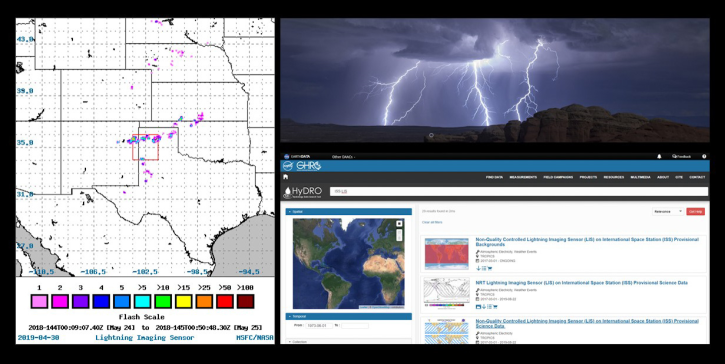
Join us to learn about the importance of lightning observations- for seasonal and long-term trends in lightning activity. We will focus on data and applications from the International Space Station's (ISS) Lightning Imaging Sensor (LIS) instrument.
Webinar
April 20, 2021

Join us as we demonstrate core use cases of Earthdata Search while highlighting key features and functionality. Whether you are a long-time Earthdata Search user or just now hearing about Earthdata Search for the first time, this webinar will be useful for you in your efforts to search for, discover, and use Earth science data.
Webinar
Feb. 9, 2021

The webinar introduces satellite remote sensing, radiance conversion, image classification, and geophysical product creation, and more.
Webinar
Jan. 29, 2021

Learn how MODIS data helped researchers assess the impact of pandemic-triggered lockdowns on air pollution in India.
Data in Action
Jan. 4, 2021
SHOWING 8 OF 171
Frequently Asked Questions
Earthdata Forum
Our online forum provides a space for users to browse thousands of FAQs about research needs, data, and data applications. You can also submit new questions for our experts to answer.
Submit Questions to Earthdata Forumand View Expert Responses