Industrial Emissions Data Access and Tools
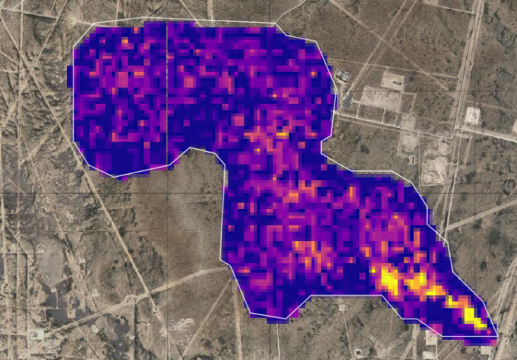
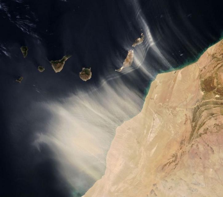
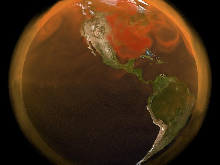
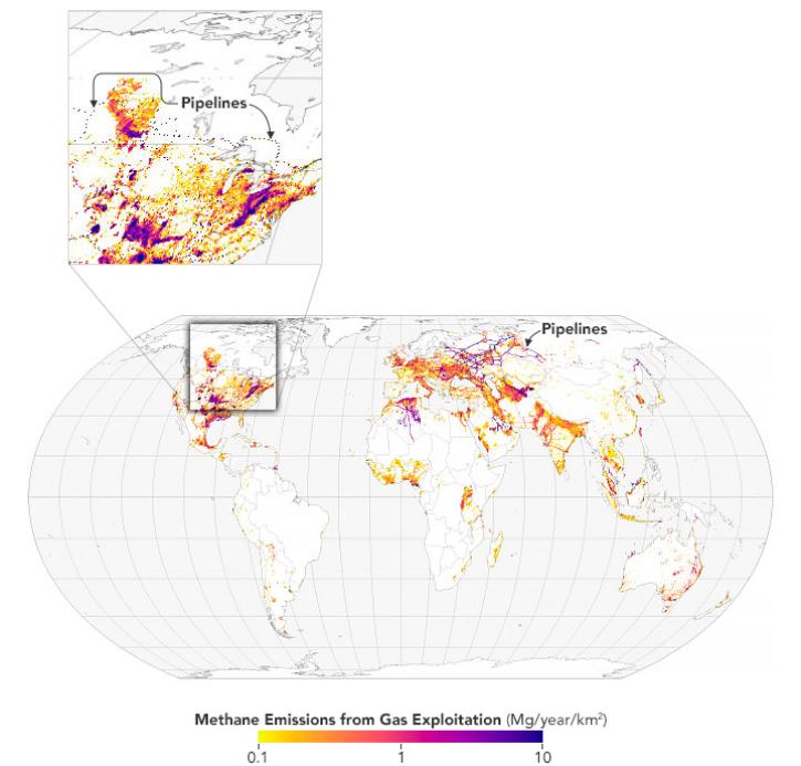
From discovery to visualization, data tools such as Earthdata Search, Panoply, and Worldview guide users in making the most of data related to greenhouse gas and industrial emissions.
Industrial Emissions Datasets
| Dataset | Version Sort ascending | Platforms | Instruments | Temporal Extent | Spatial Extent | Spatial Resolution | Data Format |
|---|---|---|---|---|---|---|---|
| ATom: Merged Atmospheric Chemistry, Trace Gases, and Aerosols, Version 2 | 2.0 | NASA DC-8 | FLUORESCENCE SPECTROSCOPY, GAS CHROMATOGRAPHS, ION CHROMATOGRAPHS, UCATS-GC, TOGA, DMT SP2, PALMS, PICARRO G2401-mc CO2, CH4, CO, H2O INSTRUMENT, MMS, WAS, AMS, CIMS, DLH, CAPS, CAFS, ATHOS | 2016-07-29 to 2018-05-21 |
N: 82.9406 S: -86.1769 E: 180 W: -180 |
netCDF-4 | |
| Anthropogenic Carbon Emission System, 2012-2017, Version 2 | 2 | COMPUTERS | Computer | 2012-01-01 to 2018-01-01 |
N: 48.1089 S: 23.0132 E: -65.3066 W: -128.267 |
netCDF-4 | |
| ATom: Merged Atmospheric Chemistry, Trace Gases, and Aerosols | 1.5 | NASA DC-8 | PALMS, WAS, LASER SPECTROMETER, SPECTROMETERS, CIMS, PHOTOMETERS | 2016-07-29 to 2018-05-21 |
N: 90 S: -90 E: 180 W: -180 |
netCDF-4 | |
| Vulcan: High-Resolution Hourly Fossil Fuel CO2 Emissions in USA, 2010-2015, Version 3 | 1 | MODELS | Computer | 2010-01-01 to 2016-01-01 |
N: 73.7533 S: 22.8582 E: -65.3082 W: -165.214 |
netCDF-4 classic | |
| CMS: Atmospheric Methane Concentrations and Prior Emissions, Boston, MA, 2012-2014 | 1 | FIELD INVESTIGATION | SPECTROMETERS | 2012-09-01 to 2014-06-30 |
N: 43.2 S: 41.5 E: -70 W: -72.2 |
CSV | |
| Longwave-infrared spectral imagery in support of COMEX, 2014 | 1 | AIRCRAFT | HSI, Mako | 2014-07-22 to 2014-07-25 |
N: 35.4969 S: 33.8929 E: -117.452 W: -119.941 |
multiple | |
| Vulcan: High-Resolution Annual Fossil Fuel CO2 Emissions in USA, 2010-2015, Version 3 | 1 | MODELS | Computer | 2010-01-01 to 2016-01-01 |
N: 73.7533 S: 22.8582 E: -65.3082 W: -165.214 |
netCDF-4 classic | |
| STAQS AVIRIS-NG-derived Methane and Carbon Dioxide Plumes, 2023 | 1 | G-III | AVIRIS-NG | 2023-06-26 to 2023-08-15 |
N: 43.6502 S: 33.7137 E: -73.0945 W: -119.678 |
multiple | |
| NACP MCI: CO2 Emissions Inventory, Upper Midwest Region, USA., 2007 | 1 | NOT APPLICABLE | NOT APPLICABLE | 2007-01-01 to 2007-12-31 |
N: 50 S: 36 E: -81 W: -105 |
multiple | |
| CMS GOSAT and ObsPack L4 Top-down yearly methane emissions for individual sectors at 0.5x0.625 degrees for North America V1 (CMS_GO_CH4_SEC_TDYC_NA) | 1 | GOSAT | TANSO-FTS | 2010-01-01 to 2017-12-31 |
N: 65 S: 15 E: -55 W: -130 |
Industrial Emissions Data Tools
| Tool Sort descending | Description | Services | |
|---|---|---|---|
| AppEEARS | The The Application for Extracting and Exploring Analysis Ready Samples (AppEEARS) offers users a simple and efficient way to perform data access and transformation processes. | Search and Discovery, Subsetting, Customization, Downloading, Visualization | |
| Panoply | Panoply is a cross-platform application that plots geo-referenced and other arrays from netCDF, HDF, GRIB, and other datasets. | Visualization, Customization, Reformatting, Subsetting, Comparison | |
| POPGRID Viewer | POPGRID Viewer explores the intercomparison of population counts and settlement mapping from leading global data sources. | Comparison | |
| STREAM | STREAM is a rapid water quality monitoring tool that processes satellite imagery to create maps showing chlorophyll-a, Total Suspended Solids, and water clarity at 20-30 meter resolution. | Processing | |
| Worldview | Worldview offers the capability to interactively browse over 1,200 global, full-resolution satellite imagery layers and download the underlying data. | Analysis, Search and Discovery, Visualization, Access, Comparison, Monitoring Natural Events |
Frequently Asked Questions
Earthdata Forum
Our online forum provides a space for users to browse thousands of FAQs about research needs, data, and data applications. You can also submit new questions for our experts to answer.
Submit Questions to Earthdata Forumand View Expert Responses