We are in the process of migrating all NASA Earth science data sites into Earthdata from now until end of 2026. Not all NASA Earth science data and resources will appear here until then. Thank you for your patience as we make this transition.
Read about the Web Unification Project
Landslides Data Access and Tools
From discovery to visualization, data tools such as Earthdata Search, Hazards Mapper, and Worldview guide users in making the most of landslide data.
Landslides Datasets
| Dataset Sort descending | Version | Platform | Instrument | Temporal Extent | Spatial Extent | Spatial Resolution | Data Format |
|---|---|---|---|---|---|---|---|
| Sentinel-1B Level 0 Product Metadata | 1 | Sentinel-1B | C-SAR | 2016-04-25 to 2021-12-24 |
N: 90 S: -90 E: 180 W: -180 |
||
| Sentinel-1B Single Look Complex Product | 1 | Sentinel-1B | C-SAR | 2016-04-25 to 2021-12-24 |
N: 90 S: -90 E: 180 W: -180 |
||
| Sentinel-1B Single Look Complex Product Metadata | 1 | Sentinel-1B | C-SAR | 2016-04-25 to 2021-12-24 |
N: 90 S: -90 E: 180 W: -180 |
||
| Sentinel-1B Single Polarization High Resolution Ground Range Detected Product | 1 | Sentinel-1B | C-SAR | 2016-04-25 to 2021-12-24 |
N: 90 S: -90 E: 180 W: -180 |
||
| Sentinel-1B Single Polarization High Resolution Ground Range Detected Product Metadata | 1 | Sentinel-1B | C-SAR | 2016-04-25 to 2021-12-24 |
N: 90 S: -90 E: 180 W: -180 |
||
| Sentinel-1B Single Polarization Medium Resolution Ground Range Detected Product | 1 | Sentinel-1B | C-SAR | 2016-04-25 to 2021-12-24 |
N: 90 S: -90 E: 180 W: -180 |
||
| Sentinel-1B Single Polarization Medium Resolution Ground Range Detected Product Metadata | 1 | Sentinel-1B | C-SAR | 2016-04-25 to 2021-12-24 |
N: 90 S: -90 E: 180 W: -180 |
||
| U.S. Climate Risk Projections by County, 2040-2049 | 1.00 | MODELS | Computer | 2040-01-01 to 2049-12-31 |
N: 72 S: 17 E: -65 W: -180 |
Shapefile, PDF, PNG, Excel |
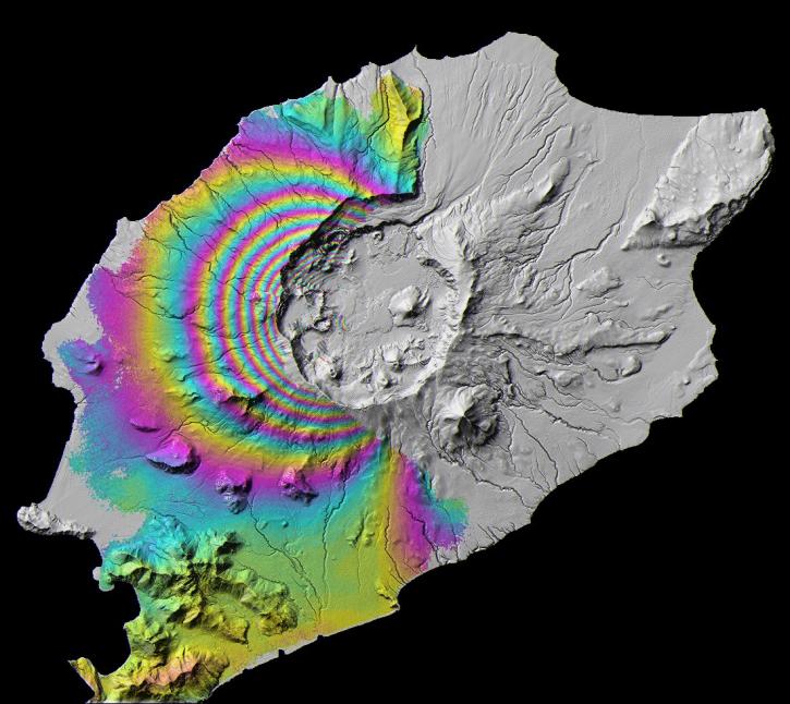
Featured Landslides Observation Method: Sentinel-1 C-SAR
The Synthetic Aperture Radar (SAR) aboard the ESA (European Space Agency's) Sentinel-1A/B satellites provides continuous all-weather, day-and-night land imagery. SAR images can be combined to produce interferograms, which are images showing changes in land height or position associated with landslides, avalanches, and rockfalls.
Join us Jan 25 at 2 p.m., ET [UTC -5], to learn how to use the Alaska Satellite Facility's OpenSARLab to work with synthetic aperture radar (SAR) data in the cloud.

Synthetic Aperture Radar (SAR) Data from NASA’s ASF DAAC helps scientists like Dr. Steve Bowman provide Utah’s citizens with timely scientific information about the state’s geologic hazards.

Dr. Williams aims to use interferometric synthetic aperture radar (InSAR) to determine the speed of every glacier on the planet.
Frequently Asked Questions
Earthdata Forum
Our online forum provides a space for users to browse thousands of FAQs about research needs, data, and data applications. You can also submit new questions for our experts to answer.
Submit Questions to Earthdata Forumand View Expert Responses