We are in the process of migrating all NASA Earth science data sites into Earthdata from now until end of 2026. Not all NASA Earth science data and resources will appear here until then. Thank you for your patience as we make this transition.
Read about the Web Unification Project
Filters

NASA's OMI and OMPS Science Investigator-led Processing Systems (SIPS) ensure that ozone data collected by instruments aboard the Aura and Suomi-NPP satellites reach global users.
Feature Article
Nov. 4, 2020

The cryosphere expert and University of Colorado Distinguished Professor of Geography was the founding director of the National Snow and Ice Data Center (NSIDC).
Feature Article
Nov. 4, 2020

Interactively explore your world your way with nearly 20 years of MODIS global imagery and the EOSDIS Worldview data visualization application.
Feature Article
Nov. 4, 2020

After being in storage for more than 40 years, data recovered from NASA's Nimbus I, II, and III missions are extending the polar sea ice record back to the 1960s and giving scientists new views of this changing environment.
Feature Article
Nov. 4, 2020
Through a shared objective of ensuring the free and open availability of Earth science data, NASA and the WDS are working together to improve international data stewardship, archiving, and use.
Feature Article
Nov. 4, 2020
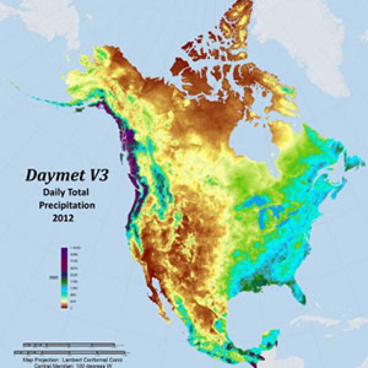
Daymet data from NASA’s Oak Ridge National Laboratory Distributed Active Archive Center (ORNL DAAC) provide almost 40 years of weather measurements for North America and are ORNL DAAC’s most popular products.
Feature Article
Nov. 4, 2020

A new comparison feature in the most recently released version of NASA’s Worldview data visualization application makes it easy to compare two images.
Feature Article
Nov. 4, 2020

Since 1999, NASA’s Terra Earth observing satellite has completed more than 100,000 orbits. The instrument data from this workhorse satellite has resulted in one of the longest continuous data records of our planet ever recorded from space.
Feature Article
Nov. 4, 2020
SHOWING 8 OF 535