Geodetics Data Access and Tools
NASA has geodetics datasets that help researchers characterize the shape of Earth and the motion of its components. Access a range of data and data tools such as AppEEARS, Worldview, and Giovanni to make the most of geodetics data.
Geodetics Datasets
| Dataset Sort descending | Version | Platforms | Instruments | Temporal Extent | Spatial Extent | Spatial Resolution | Data Format |
|---|---|---|---|---|---|---|---|
| GNSS GLONASS Combined Broadcast Ephemeris Data (30-second sampling, daily files) from NASA CDDIS | 1 | GLONASS, GROUND STATIONS | GLONASS P, GNSS | 1992-01-01 to Present |
N: 90 S: -90 E: 180 W: -180 |
RINEX | |
| CDDIS MEaSUREs SESES GNSS products Daily 5-minute Precise Point Positioning (PPP) Tropospheric Estimates | 1 | GLONASS, GPS, GROUND STATIONS | GLONASS RECEIVERS, GPS, GNSS RECEIVER | 1992-01-01 to Present |
N: 90 S: -90 E: 180 W: -180 |
SOPAC GLOBK ATS Model | |
| CDDIS MEaSUREs SESES products 3D station velocity estimates | 1 | GLONASS, GPS, GROUND STATIONS | GLONASS RECEIVERS, GPS, GNSS RECEIVER | 1992-01-01 to Present |
N: 90 S: -90 E: 180 W: -180 |
SINEX header, text file | |
| CDDIS MEaSUREs SESES products Change in Water Storage Time Series | 1 | GLONASS, GPS, GROUND STATIONS | GLONASS RECEIVERS, GPS, GNSS RECEIVER | 1992-01-01 to Present |
N: 90 S: -90 E: 180 W: -180 |
SINEX | |
| CDDIS MEaSUREs SESES products High-rate Earthquake Displacement | 1 | GLONASS, GPS, GROUND STATIONS | GLONASS RECEIVERS, GPS, GNSS RECEIVER | 1992-01-01 to Present |
N: 90 S: -90 E: 180 W: -180 |
text, image, metadata, and binary data files | |
| CDDIS MEaSUREs SESES products Horizontal Strain Rate Grids | 1 | GLONASS, GPS, GROUND STATIONS | GLONASS RECEIVERS, GPS, GNSS RECEIVER | 1992-01-01 to Present |
N: 90 S: -90 E: 180 W: -180 |
netCDF, PDF | |
| CDDIS MEaSUREs SESES products Plate Boundary Aseismic Transient Deformation | 1 | GLONASS, GPS, GROUND STATIONS | GLONASS RECEIVERS, GPS, GNSS RECEIVER | 1992-01-01 to Present |
N: 90 S: -90 E: 180 W: -180 |
ASCII, PDF | |
| CDDIS MEaSUREs SESES products Weekly Coseismic Offset Time Series | 1 | GLONASS, GPS, GROUND STATIONS | GLONASS RECEIVERS, GPS, GNSS RECEIVER | 1992-01-01 to Present |
N: 90 S: -90 E: 180 W: -180 |
Text | |
| CDDIS MEaSUREs SESES products weekly displacement grids time series | 1 | GLONASS, GPS, GROUND STATIONS | GLONASS RECEIVERS, GPS, GNSS RECEIVER | 1992-01-01 to Present |
N: 90 S: -90 E: 180 W: -180 |
netCDF, PDF, MP4 | |
| Combined GPS Broadcast Ephemeris Data (30-second sampling, hourly files) from NASA CDDIS | 1 | Beidou, Galileo, GLONASS, GPS, GROUND STATIONS, QZSS, IRNSS, SBAS | Beidou P, Galileo P, GLONASS P, GPSP, GNSS, QZSS P, IRNSS P, SBAS P | 1992-01-01 to Present |
N: 90 S: -90 E: 180 W: -180 |
RINEX |
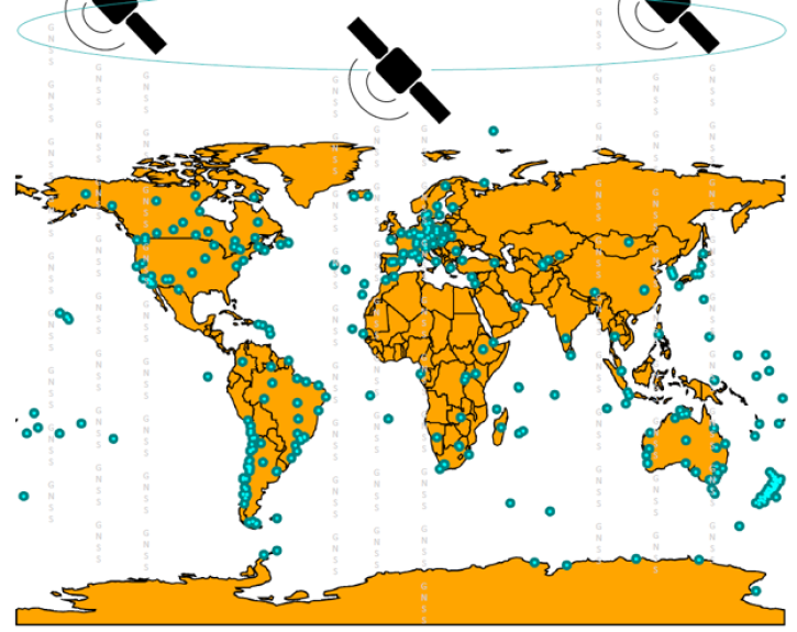
GNSS data can used to determine location and positioning around Earth as well as to study geophysics, the motions of tectonic plates and their displacements due to earthquakes, Earth orientation, and atmospheric properties among many other things.
Frequently Asked Questions
Earthdata Forum
Our online forum provides a space for users to browse thousands of FAQs about research needs, data, and data applications. You can also submit new questions for our experts to answer.
Submit Questions to Earthdata Forumand View Expert Responses


