We are in the process of migrating all NASA Earth science data sites into Earthdata from now until end of 2026. Not all NASA Earth science data and resources will appear here until then. Thank you for your patience as we make this transition.
Read about the Web Unification Project
Geodetics Data Access and Tools
NASA has geodetics datasets that help researchers characterize the shape of Earth and the motion of its components. Access a range of data and data tools such as AppEEARS, Worldview, and Giovanni to make the most of geodetics data.
Geodetics Datasets
| Dataset Sort descending | Version | Platforms | Instruments | Temporal Extent | Spatial Extent | Spatial Resolution | Data Format |
|---|---|---|---|---|---|---|---|
| Ground-Based Global Navigation Satellite System (GNSS)-based Upper Atmospheric Realtime Disaster Information and Alert Network (GUARDIAN) GPS daily antenna phase centers (24-hour files) from NASA CDDIS | 1 | GPS, GROUND STATIONS | 2023-10-01 |
N: 90 S: -90 E: 180 W: -180 |
JPL Piecewise Constant Model Parameter (ASCII) | ||
| Ground-Based Global Navigation Satellite System (GNSS)-based Upper Atmospheric Realtime Disaster Information and Alert Network (GUARDIAN) GPS daily antenna phase maps (meta data, 24-hour files) from NASA CDDIS | 1 | GPS, GROUND STATIONS | 2023-10-01 |
N: 90 S: -90 E: 180 W: -180 |
JPL MetaFile (ASCII) | ||
| Ground-Based Global Navigation Satellite System (GNSS)-based Upper Atmospheric Realtime Disaster Information and Alert Network (GUARDIAN) GPS Earth Orientation Parameters (1-day sampling, 7-day files) from NASA CDDIS | 1 | GPS, GROUND STATIONS | 2023-10-01 |
N: 90 S: -90 E: 180 W: -180 |
JPL GEOP (ASCII) | ||
| Ground-Based Global Navigation Satellite System (GNSS)-based Upper Atmospheric Realtime Disaster Information and Alert Network (GUARDIAN) Near Real-Time Ionospheric Total Electron Count (5-second sampling, 24-hour files) from NASA CDDIS | 1 | Galileo, GROUND STATIONS | GNSS RECEIVER | 2022-09-01 |
N: 90 S: -90 E: 180 W: -180 |
CSV | |
| Ground-Based Global Navigation Satellite System Combined Broadcast Ephemeris Data (daily files) from NASA CDDIS | 1 | Beidou, Galileo, GLONASS, GPS, GROUND STATIONS, QZSS, IRNSS, SBAS | Beidou P, Galileo P, GLONASS P, GPSP, GNSS RECEIVERS, QZSS P, IRNSS P, SBAS P | 1992-01-01 to Present |
N: 90 S: -90 E: 180 W: -180 |
RINEX | |
| Ground-Based Global Navigation Satellite System Data (30-second sampling, 1 hour files) from NASA CDDIS | 1 | Beidou, Galileo, GLONASS, GPS, GROUND STATIONS, QZSS, IRNSS | Beidou RECEIVERS, Galileo RECEIVERS, GLONASS RECEIVERS, GPS RECEIVERS, GNSS RECEIVER, QZSS RECEIVERS, IRNSS RECEIVERS | 2005-10-07 to Present |
N: 90 S: -90 E: 180 W: -180 |
RINEX | |
| Ground-Based Global Navigation Satellite System Data (30-second sampling, 24 hour files) from NASA CDDIS | 1 | Beidou, Galileo, GLONASS, GPS, GROUND STATIONS, QZSS, IRNSS | Beidou RECEIVERS, Galileo RECEIVERS, GLONASS RECEIVERS, GPS RECEIVERS, GNSS RECEIVER, QZSS RECEIVERS, IRNSS RECEIVERS | 1992-01-01 to Present |
N: 90 S: -90 E: 180 W: -180 |
||
| Ground-Based Global Navigation Satellite System GLONASS (GLObal NAvigation Satellite System) Summary Data (30-second sampling, daily files) from NASA CDDIS | 1 | GLONASS, GROUND STATIONS | GLONASS P, GNSS RECEIVER | 1998-01-01 to Present |
N: 90 S: -90 E: 180 W: -180 |
RINEX V2 | |
| Ground-Based Global Navigation Satellite System High-rate Mixed Broadcast Ephemeris Data (sub-hourly files) from NASA CDDIS | 1 | Beidou, Galileo, GLONASS, GPS, GROUND STATIONS, QZSS, IRNSS, SBAS | Beidou P, Galileo P, GLONASS P, GPSP, GNSS RECEIVER, QZSS P, IRNSS P, SBAS P | 1992-01-01 to Present |
N: 90 S: -90 E: 180 W: -180 |
RINEX | |
| Ground-Based Global Navigation Satellite System Mixed Broadcast Ephemeris Data (daily files) from NASA CDDIS | 1 | Beidou, Galileo, GLONASS, GPS, GROUND STATIONS, QZSS, IRNSS, SBAS | Beidou P, Galileo P, GLONASS P, GPSP, GNSS RECEIVER, QZSS P, IRNSS P, SBAS P | 1992-01-01 to Present |
N: 90 S: -90 E: 180 W: -180 |
RINEX |
SHOWING 10 OF 231
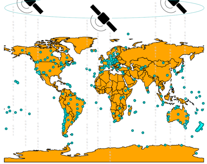
Featured Geodetics Observation Method: GNSS
A Global Navigation Satellite System (GNSS) is a space geodesy technology that provides autonomous geospatial positioning around the world. One such system is the U.S. Global Positioning System (GPS), which is made up of 24 satellites, each traveling in a 12-hour orbit. A similar system is the GLObal NAvigation Satellite System (GLONASS) constellation consisting of 24 satellites. Each system is designed so that multiple satellites are within range of any point on Earth in order to precisely determine its location.
GNSS data can used to determine location and positioning around Earth as well as to study geophysics, the motions of tectonic plates and their displacements due to earthquakes, Earth orientation, and atmospheric properties among many other things.
GNSS data can used to determine location and positioning around Earth as well as to study geophysics, the motions of tectonic plates and their displacements due to earthquakes, Earth orientation, and atmospheric properties among many other things.

Join us on Wednesday, July 22, 2015 at 2pm ET to learn how to discover and access the real-time Global Navigation Satellite System (GNSS) data!

Join us to learn more about Global Navigation Satellite System (GNSS) radio occultation science and applications! We will highlight science impacts in the areas of numerical weather prediction, forecasting cyclone genesis, and space weather.
Join us on Sept. 28 to learn about the NASA Making Earth System Data Records (ESDR) for Use in Research Environments (MEaSUREs) Extended Solid Earth Science ESDR System (ESESES) project, whose Global Navigation Satellite System (GNSS)-derived data products enable research on tectonic motion, crustal deformation, earthquakes, tsunamis, sea level rise, extreme weather, and more!

This update to NASA's Crustal Dynamics Data Information System (CDDIS) archive makes accessing all RINEX data easier and more transparent for the Global Navigation Satellite System (GNSS) user community.
Frequently Asked Questions
Earthdata Forum
Our online forum provides a space for users to browse thousands of FAQs about research needs, data, and data applications. You can also submit new questions for our experts to answer.
Submit Questions to Earthdata Forumand View Expert Responses